This item has been sold, but you can get on the Waitlist to be notified if another example becomes available, or purchase a digital scan.
1845 Teesdale Dissected Library Map of the World (w/ Republic of Texas)
World-teesdale-1845-2$4,250.00


Title
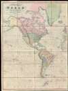
A New Chart of the World On Mercator's Projection With The Tracks Of The Most Celebrated and Recent Navigators.
1845 (dated) 51 x 77 in (129.54 x 195.58 cm) 1 : 20000000
1845 (dated) 51 x 77 in (129.54 x 195.58 cm) 1 : 20000000
Description
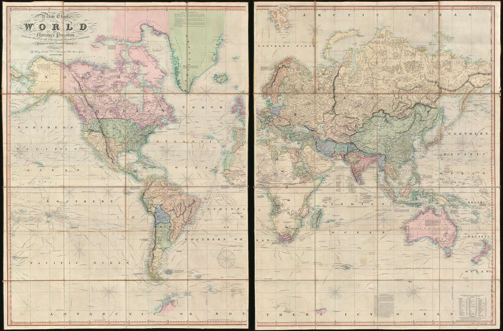
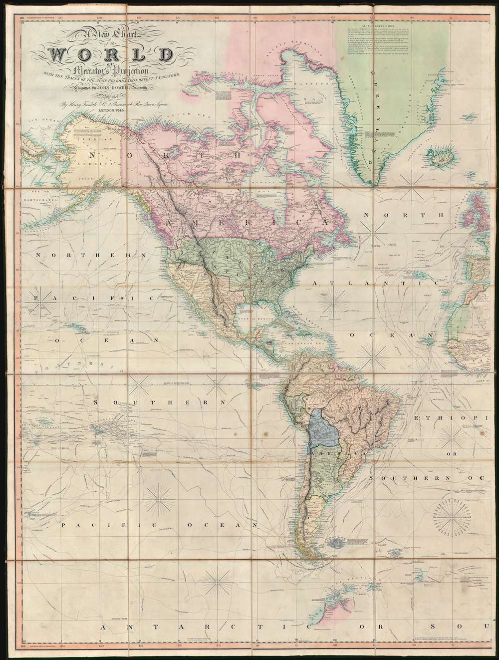
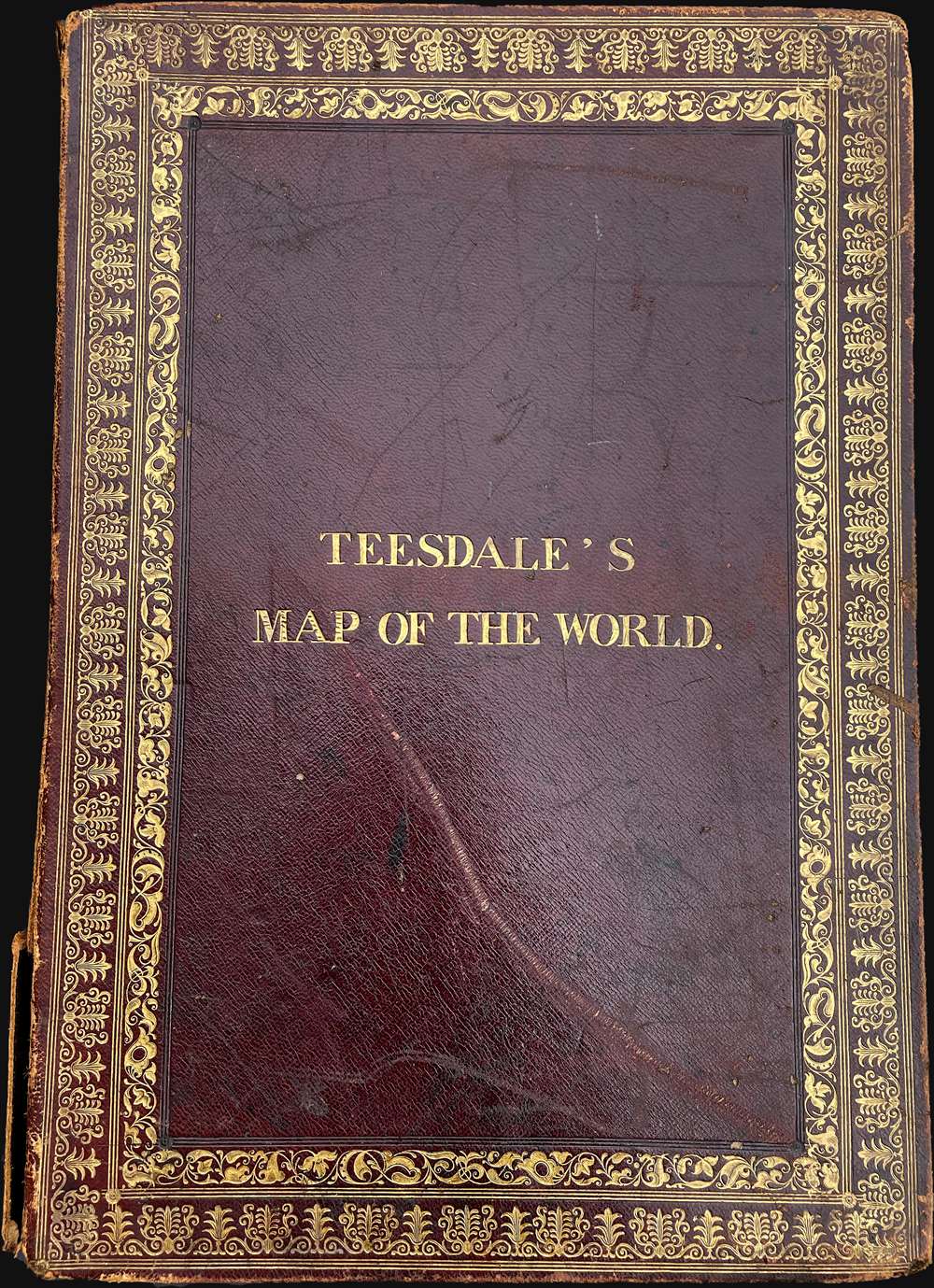
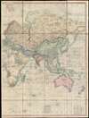
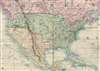
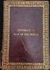
This is an impressive 1845 large format map of the world by Henry Teesdale. The map covers the entire world on a Mercator projection with copious notes and annotations throughout. It is significant for many reasons, but chief among them is that it is one of the few English maps to recognize the Republic of Texas (as England itself did not) - and depict its most ambitious boundary configuration. It is also the first map to show a complete northwest passage following the Deese-Simpson Expedition. The map is thorough, including the most up to date political events and discoveries, but also tends to be biased, although not always towards Anglo-centric interests. For example, the map agrees with British claims to British Columbia relating to the 54/40 Oregon Question, and ignores the discoveries of Charles Wilkes (1798 - 1877) and the U.S. Exploring Expedition (1838 - 1842), no doubt to bolster the competing exploratory claims of Englishman John Ross (1777 - 1856). Teesdale's map is beautifully presented in two sections, each of which have been dissected into sixteen panels and laid on linen. The whole folds into a beautifully tooled leather binder with marbled endpapers.
The Annotations
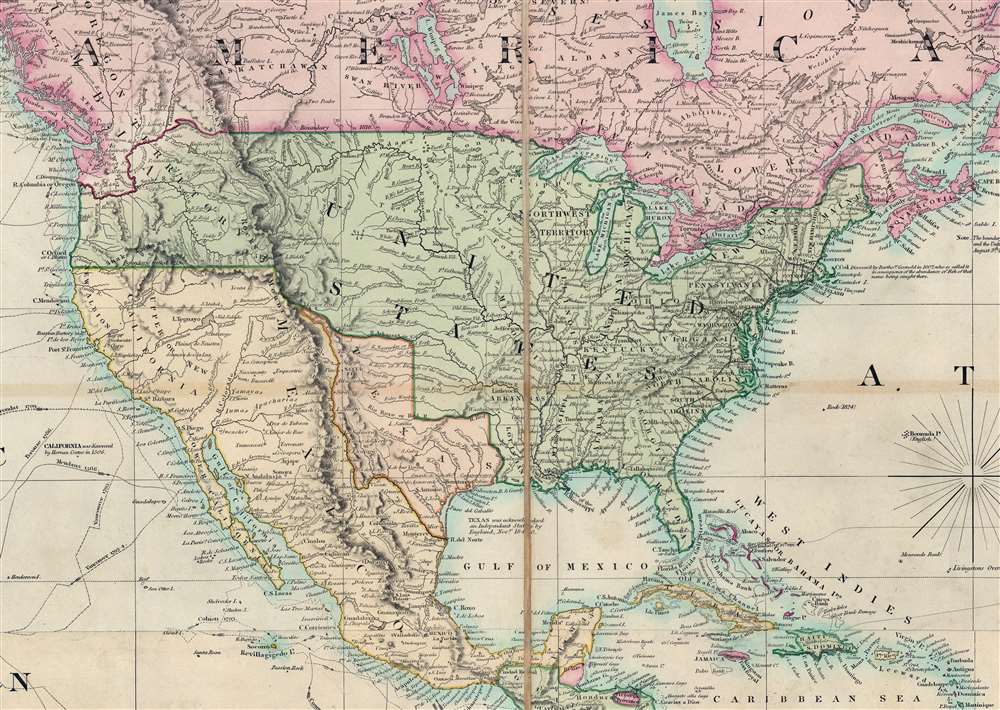
The enormous size of this map allowed Teesdale to accommodate a quantity of detailed annotations on natural wonders, historical events, expirations, and political treaties. These are so prolific and charming we will allow them to speak for themselves:Texas is represented at its fullest extent as in independent republic. An annotation reads: Texas was acknowledged an Independent State by England, Novr. 1840. (Fact Check: England never recognized the Republic of Texas - see below.)
Just off the coast of Norway, at the site of the legendary Loften Maelstrom, the following annotation reads: The Maelstrom, This celebrated Whirlpool is an immense circle of a mile and a half in diameter; the Velocity increasing as it approximates the center, there forming a vortex, the largest Ship meet with instant destruction on entering it. (Fact Check: alas, not the wonder today it once may once have been.)
Off the northeastern coast of Australia the Great Barrier Reef is recognized in conjunction with the HMS Bounty Mutiny: Great Barrier Reefs, here the Ship Pandora Capt. Edwards with 14 of the Mutinous crew of the Bounty on board who were captured at Otaheite was lost, 35 of the Crew and 4 of the Prisoners perished in the latter end of June 1791.
In Liberia, Africa: This district has been purchas'd from the Native Chiefs by a Company of American Philanthropists, (called the Colonization Society) for the purpose of forming Settlements for the Emancipated Slaves of the United States, and is now in a flourishing condition. (Fact Check: We wonder at Teesdale's idea of 'flourishing'?)
Republic of Texas
The Republic of Texas was a short-lived nation established in March of 1836 when it ceded from Mexico. Following the independence of Mexico from Spain, the American Stephen Fuller Austin (1793 - 1836) led a group of 300 Empresarios to settle Texas, near Austin, where they received a grant from the Mexican government. As more Americans moved to Texas, resentment evolved into strife between the American settlers and Mexican authorities. This and other factors instigated 1835 Texan Revolution and the 1846 Declaration of Texan Independence. Texas remained an independent republic until it joined the United States ten years later in 1846.England and the Republic of Texas
Unlike France, England never formally recognized the Republic of Texas. England instead had much closer ties to Mexico, over whom it held significant debt. In the late 1830s, Mexico even made a proposal to sell Texas to England as repayment of debt. While this proposal did not go anywhere in Parliament, the fact that it was offered underscores a close diplomatic and economic relationship. For Texas's part, the new republic was eager for recognition in Europe, and sent General James Hamilton (1786 - 1857) of South Carolina and James Pinckney Henderson (1808 - 1858) of North Carolina to represent their interests. The duo went first to England, at the time the leading trade power in Europe, where they set up an informal legation (4 St. James St.). Despite persistent negotiations, they were unable to achieve full recognition of the Republic of Texas, and the mission to England has long been regarded as a failure. Eventually, in November of 1840, they were able to secure three trade agreements that flirted with but failed to fully recognize Texas independence - which is no doubt what Teesdale's annotation references. Hamilton also visited the court of King Louis Philippe I in France, where he had far greater success, securing in 1839 the formal French recognition of the Republic of Texas. In Europe, only France, Belgium, and the Netherlands formally recognized the Republic of Texas, leading to most European maps depicting the Republic being French.Unusual Texas Border Configuration
Publications by Teesdale and Dower are among only a small handful of English maps to name the Republic of Texas and possibly the first world map to do so. But, there is an additional nuance. The borders of the Republic as presented here are most unusual, representing the full claims of the republic of Texas. At the time there was considerable debate over the western border: Texas claimed the Rio Grande del Norte as its western and southernmost border, while Mexico argued for a boundary much further east at the Nueces River. Most European and American maps of the time followed the Mexican boundary at the Nueces River, thus presenting much smaller Republic of Texas. It was not until 1846, when Texas was annexed into the United States according to the full Texas-claimed border that maps illustrating the Rio Grande border became commonplace - which makes this map exceptionally unusual. Editions of the Teesdale from 1841 on wards illustrated the Rio Grande border and the stovepipe configuration - and are the only European maps to do so - suggesting that Teesdale and Dower must have had strong Pro-Texas sympathies.54-40 or Fight! American Claims to British Columbia
Curiously for a British map, Teesdale prematurely settles the Oregon Question in favor of the Britain, ceding most of modern-day Washington. Following the transcontinental crossing of North America by the British Northwest Company sponsored explorer Alexander MacKenzie (1792 – 1793), and the American expedition of Lewis and Clark up the Missouri to the mouth of the Columbia River (1804 – 1806), it became apparent that control of the fur and resource rich Pacific Northwest would bring wealth and power to whomever could assert sovereignty. The American tycoon John Jacob Astor (1763 - 1848), with the permission of President Thomas Jefferson, was the first to attempt a permeant trading colony in the region, founding Astoria on the Columbia River in 1811. This quickly led to a confrontation with the established British-Canadian Northwest Company. Americans in the 1820s through the 1840s argued that most of the Pacific Northwest should be part of the United States as a legacy of the 1803 Louisiana Purchase. England, on the other hand, argued for residual claims to the region derived from the MacKenzie Expedition (1825 - 1827) and its commercial fur trading empires: The Northwest Company and the Hudson Bay Company. The Oregon Dispute, as it came to be known, evolved into a geopolitical issue between the British Empire and the United States, especially after the War of 1812. Americans adopted the slogan '54-40 or Fight!' until the Oregon Question was finally resolved roughly along the current borderline by the 1846 Oregon Treaty.The First Map to Show a Fully Explored Northwest Passage
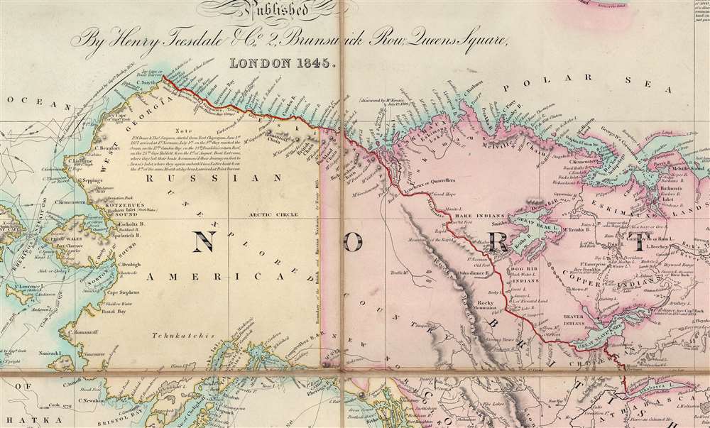
This is one of the first maps to illustrate a full Northwest Passage based upon actual exploration. Bold red highlighting traces the track of the Dease-Simpson MacKenzie River Expedition (1836 - 1839) along the coast of Alaska as far as Point Barrow - the completing the northwest passage roughly along the northern shoreline of America. A note reads 'This Coast was Explored by Mess.rs Dease and Simpson, under the Hon.ble Hudson's Bay Company, which completes the North West Passage Oct.r 1839'. British-Canadian fur traders Peter Dease (1788 - 1863) and Thomas Simpson (1808 - 1840) completed the exploration begun by Sir John Franklin (1786 - 1847), connecting Franklin's western most point, Return Reef (1826) with Frederick William Beechey's (1796 - 1856) easternmost achievement, Point Barrow (1826). Although Deese and Simpson completed the map of North America's northern coast, properly discovering a Northwest Passage, the route was (and remains) unnavigable. The Northwest Passage that is now navigable, due to global warming, lies much farther north.Publication History and Census
Teesdale and engraver John Crane Dower first issued this map in 1836. Some have speculated that this map was intended as competition to the 1837 Mitchell map of the world, which it resembles, but that speculation is based upon the assumption that the first edition of this map was 1841. Our recent discovery of an 1836 edition suggests that in so far as the two maps were related, Mitchell was in fact following Teesdale. Subsequent editions followed in 1841, 1842, 1844 (present example) and 1845. The 1841 edition and those following were updated to reflect the Republic of Texas. All examples are uncommon.CartographerS
Henry Teesdale (December 1776 - January 1856) was a British map publisher active in the first half of the 19th century. Teesdale was born in London. He was elected to the Royal Geographical Society in 1830. Teesdale initially partnered with John Hordan and William Colling Hobson as Henry Teesdale and Company, but this partnership was dissolved in 1832. Afterwards Teesdale continued to publish maps and atlases on his own account. He worked with several major British map engravers of the period including John Crane Dower, Christopher Greenwood, and Josiah Henshall, among others. His most prominent work is a large map of the world engraved by Dower. He must have enjoyed considerable commercial success because in 1845 he is registered as a partner in the Royal Bank of Scotland. Teesdale died in January of 1856 and was buried in All Souls, Kensal Green. More by this mapmaker...
John Crane Dower (1791 - February 20, 1847) was an English engraver, map publisher, and printer active in northern London during the first half of the 19th century. Dower had his office at 6 Cumming Place, Pentonville, London. He was most active as an engraver from 1820 to 1847, where he produced work for John Greenwood, William Fowler, Henry Teesdale, Thomas Moule, Geroge Bradshaw, and others. Dower passed his business on two his two sons, John James Downer, and Fredreric Jamesd Dower. Learn More...
Condition
Very good. Accompanied by original leather binder.
References
Rumsey 2830.001. OCLC 558042121.