Digital Image: 1880 Jilek Map of the World showing Ocean Currents and Winds
WorldCurrents2-jilek-1880_d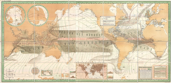

Title
Zu Dr. Jileks Oceanografie.
1880 (undated) 21.75 x 45.5 in (55.245 x 115.57 cm) 1 : 28500000
1880 (undated) 21.75 x 45.5 in (55.245 x 115.57 cm) 1 : 28500000
Description
FOR THE ORIGINAL ANTIQUE MAP, WITH HISTORICAL ANALYSIS, CLICK HERE.
Digital Map Information
Geographicus maintains an archive of high-resolution rare map scans. We scan our maps at 300 DPI or higher, with newer images being 600 DPI, (either TIFF or JPEG, depending on when the scan was done) which is most cases in suitable for enlargement and printing.
Delivery
Once you purchase our digital scan service, you will receive a download link via email - usually within seconds. Digital orders are delivered as ZIP files, an industry standard file compression protocol that any computer should be able to unpack. Some of our files are very large, and can take some time to download. Most files are saved into your computer's 'Downloads' folder. All delivery is electronic. No physical product is shipped.
Credit and Scope of Use
You can use your digial image any way you want! Our digital images are unrestricted by copyright and can be used, modified, and published freely. The textual description that accompanies the original antique map is not included in the sale of digital images and remains protected by copyright. That said, we put significant care and effort into scanning and editing these maps, and we’d appreciate a credit when possible. Should you wish to credit us, please use the following credit line:
Courtesy of Geographicus Rare Antique Maps (https://www.geographicus.com).
How Large Can I Print?
In general, at 300 DPI, you should at least be able to double the size of the actual image, more so with our 600 DPI images. So, if the original was 10 x 12 inches, you can print at 20 x 24 inches, without quality loss. If your display requirements can accommodate some loss in image quality, you can make it even larger. That being said, no quality of scan will allow you to blow up at 10 x 12 inch map to wall size without significant quality loss. For more information, it is best consult a printer or reprographics specialist.
Refunds
If the high resolution image you ordered is unavailable, we will fully refund your purchase. Otherwise, digital images scans are a service, not a tangible product, and cannot be returned or refunded once the download link is used.
Cartographer
August von Jilek (August 28, 1819 – November 8, 1898) was a Czech physician, scientist, and bureaucrat active with the Austrian Imperial Navy in the second half of the 19th century. He was born at Litomyšl in Bohemia, now in the Czech Republic, where the Jilek surname can be traced back to the 15th century. He studied medicine in Vienna and afterwards, around 1845, enlisted in the Austrian Imperial Navy. He must have served with considerable distinction, as he was chosen to be the personal physical to Archduke Ferdinand Maximillian (1832 – 1867). Ferdinand Maximillian, then the Commander and Chief of the Navy, founded a new Imperial Naval Academy at Pola, in Istria. Jilek took a post there lecturing on Oceanography, a subject for which he had no formal education but a great passion. In conjunction with his new position he compiled a textbook, Lehrbuch der Oceanographie, for which he best known today. Jilek is often criticized for not being a particularly innovative or original researcher in this field, nonetheless, he was excellent at compiling the research of others, particularly Matthew Fontaine Muray, Eduard Brobrick, and Immanuel Kant. His work is notable as only the second work to contain the term 'oceanography' in the title. In addition to his oceanographic work, Jilek produced two medical studies focusing on Malaria. In 1864 he gave up his academic post to escort to escort his patron, now the ill-fated Emperor Maximillian I, to his new kingdom of in Mexico. Wisely Jilek did not remain, returning to his government position in Europe. He died in Trieste on November 8 of 1889. More by this mapmaker...