This item has been sold, but you can get on the Waitlist to be notified if another example becomes available, or purchase a digital scan.
1779 Blair Map of the World in Hemispheres with Latest Discoveries
WorldDiscoveries-blair-1779$275.00

Title
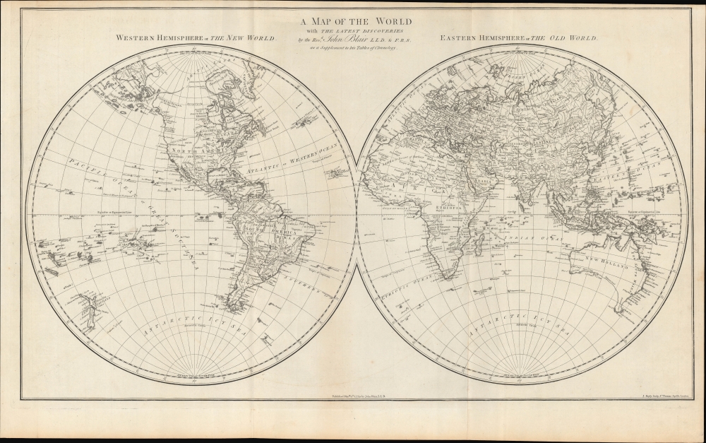
A Map of the World with the Latest Discoveries.
1779 (dated) 16 x 27.75 in (40.64 x 70.485 cm) 1 : 65000000
1779 (dated) 16 x 27.75 in (40.64 x 70.485 cm) 1 : 65000000
Description
A fascinating 1779 map of the world in two hemispheres engraved by John Bayly and published in the early phase of a string of discoveries in the late 18th century. Though many uncertainties remained in polar regions and northwestern America, the contours of the world map as we know it today were clearly coming into focus.
Considerable attention is paid to small islands in the Atlantic and Pacific Oceans, due to their importance for navigation, which make them appear to be bigger than their actual size. Some of these islands were poorly understood (such as 'Nameless Isles known to the Spaniards') or illusory. Nevertheless, the map serves as an excellent snapshot of the latest geographical knowledge on the eve of voyages of Vancouver, La Pérouse, Cook's Third Voyage, and other great discoveries at the end of the 18th century.
A Closer Look
This map was produced while many of the great voyages of exploration in the late 18th century were still ongoing or had not yet taken place. The results of Cook's first and second voyages, important for determining the geography of the South Pacific, New Zealand, and Australia (New Holland, here with Tasmania connected), are incorporated. However, his fateful third voyage, which yielded new information on the west coast of North America and the Sandwich Islands (Hawaii), was still ongoing when this map was published. As a result, the Hawaiian Islands are not present here, while the outlines of Alaska, Greenland, Japan, New Guinea, and other locations remain uncertain. The interior of the Americas and Africa are similarly sketchy; for example, Ethiopia is distinguished from Abyssinia and placed in the center of the continent.Considerable attention is paid to small islands in the Atlantic and Pacific Oceans, due to their importance for navigation, which make them appear to be bigger than their actual size. Some of these islands were poorly understood (such as 'Nameless Isles known to the Spaniards') or illusory. Nevertheless, the map serves as an excellent snapshot of the latest geographical knowledge on the eve of voyages of Vancouver, La Pérouse, Cook's Third Voyage, and other great discoveries at the end of the 18th century.
Publication History and Census
This map was engraved by John Bayly in 1779 for John Blair's book The Chronology and History of the World from the Creation to the year of Christ, 1779, published in London the same year. This work was published in multiple editions between 1753 and 1856, with this map first appearing in the 1779 edition. It is independently cataloged by the Denver Public Library, the University of Wisconsin - Milwaukee, the National Library of Scotland, and the National Library of Australia, while the 1779 edition of the entire work is similarly rare, noted among the holdings of three institutions in Europe.Cartographer
John Abraham Bayly (c. 1730 - c. 1794) was an English engraver. Born around 1730, Bayly apprenticed with Thophilus Spendelow on October 16, 1745. After Spendelow died, Bayly finished his apprenticeship with his widow Hannah, which ended on December 3rd, 1755. He was jailed in Ludgate Prison for debt on September 25, 1761 and was most likely the John Bayly who testified as the principal witness in a forgery trial on October 17th 1783. More by this mapmaker...
Source
Blair, J., The Chronology and History of the World from the Creation to the year of Christ, 1779, (London) 1779.
Condition
Very good. Light wear along original fold lines. Close top margin.
References
OCLC 877610524, 823635287.