1780 Bowles Map of the World in Two Hemispheres
WorldHemispheres-bowles-1780$2,500.00

Title
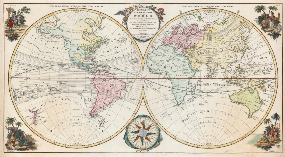
Bowles's New Pocket Map of the World, laid down from the latest observations and comprehending the New Discoveries to the present Time, particularly those lately made in the Southern Seas By Byron, Wallis, Cook, Bougainville, and others.
1780 (dated) 15.25 x 28.25 in (38.735 x 71.755 cm) 1 : 75000000
1780 (dated) 15.25 x 28.25 in (38.735 x 71.755 cm) 1 : 75000000
Description
This is the 1780 Carington Bowles double hemisphere map of the world. Divided into the 'Western Hemisphere or the New World' and the 'Eastern Hemisphere of the Old World', Bowles illustrates the age of exploration and discovery.
A Closer Look
The Old World appears much as one would expect. Europe's major powers are illustrated in some detail, with capitals and other major cities identified. Africa is a contradiction since its coastline had been relatively well mapped, but the interior remained relatively unknown. Bowles thus leaves Africa mostly blank, absent of illustrations and conjecture. Personifications of the four continents occupy the corners, with Europe appearing as a well-dressed noble astride a horse, and the illustrations for America, Asia, and Africa emphasizing exoticism.Asia
Intriguing cartography abounds in Asia. A reasonably accurate mapping of the East Indies underlines their continued importance to international trade. Dashed lines trace the routes of Anson, Bougainville, and Cook across the Indian Ocean, through the East Indies and the Philippines, and east into the Pacific.De Gama Land
Also of interest is Bowles' mapping of 'the Companies' Land' of Terre de Compagnie, just to the south of Siberia, also known as Gamaland. Gama or Gamaland was supposedly discovered in the 17th century by a mysterious figure known as Jean de Gama. Various subsequent navigators claim to have seen this land, but it was left to Bering to finally debunk the myth. In 1729, he sailed for three days looking for Juan de Gama Land but never found it. At times it was associated with Hokkaido, in Japan, and at other times with the mainland of North America. Bowen clearly does not give up on the idea. The truth of Gama is most likely little more than a misinterpretation of the Aleutian Archipelago as a single body of land. It continued to appear in maps for about fifty years following the Bering's voyages until the explorations of Cook confirmed the findings.Hokkaido
The mapping of Hokkaido (here identified as Yedso) joined to Sakhalin refers to the cartography of Maerten de Vries and Cornelis Jansz Coen, who explored this land in 1643 in search of the gold and silver-rich islands mentioned in a Spanish legend. Vries and Coen were the first Europeans to enter these waters, which were little known even to the Japanese. They mapped the Strait of Vries and they believed this strait to separate Asia from America, of which Compagnies Land formed part, thus elucidating its magnificent proportions. They were also the first European navigators to discover Sakhalin and map its southern coastline. Apparently, the Castricum was mired in a heavy fog as it attempted to explore these seas and thus Vries and Coen failed to notice the strait separating Yedo (Hokkaido) from Sakhalin, initiating a cartographic error that would persist well into the 18th century. Despite their many successes, the expedition ultimately failed to discover islands of silver and gold, thus proving definitively to Van Diemen that indeed, no such lands ever existed.North America
The English Colonies (which were fighting the American Revolutionary War at the time) the colonies of Virginia, North Carolina, South Carolina, Georgia, and Florida all stretch from the Atlantic Ocean to the Mississippi River – reflecting this historical coast-to-coast charters. New England, New York, Pennsylvania, New Jersey, and Maryland appear as well. Canada is concentrated around the St. Lawrence River, but reflects claims to Great Lakes. Louisiana lacks defined borders. New Mexico is contained within Louisiana with dotted borders akin to those separating the rebellious American colonies. An intriguing inlet along the west coast of North America, potentially illustrates the Columbia River underscores the European quest for a Northwest Passage.The Muller Peninsula
The Muller Peninsula is a large speculative peninsula that bears a vague resemblance in location and form to Alaska. It was postulated by Gerhard F. Müller based upon his reading of the Bering-Chirikov reports. Bering and Chirikov skirted the Aleutian Islands, sighting land on numerous occasions, before reaching the North American mainland and sighting Mount Saint Elias (Mont de St. Elie). By drawing a line between Bering's sightings of the Aleutian Islands, Müller presumed them connected in the form of a vast Aleutian peninsula. Despite the exaggerated westward proportions of Muller's Peninsula, his mapping, as seen here, is significant in that itconfirmed the existence of a body of water between Asia and America, the subject of much dispute during the previous two hundred years. It also showed the Kurile Islands correctly and suggested the outline of Alaska and the Aleutian chain. Though the Russian discoveries had been shown on the De L'Isle map ... published in 1752, … this is the first map to give an approximate picture of what is now Alaska.
South America and the Pacific
Islands dot the South Pacific and lines trace the voyages of Cook, Bougainville, and Anson. Very little inland detail appears in South America. However, the Orinoco, Negro, and Amazon rivers are illustrated. A large lake labeled 'L. of Chartes' occupies part of central South America as the source of the Paraguay River. This is the apocryphal Laguna de Xarayes.Laguna de Xarayes
The mythical Laguna de Xarayes is illustrated here as the northern terminus, or source, of the Paraguay River. The Xarayes, a corruption of 'Xaraies' meaning 'Masters of the River', were an indigenous people occupying what are today parts of Brazil's Matte Grosso and the Pantanal. When Spanish and Portuguese explorers first navigated up the Paraguay River, as always in search of El Dorado, they encountered the vast Pantanal flood plain at the height of its annual inundation. Understandably misinterpreting the flood plain as a gigantic inland sea, they named it after the local inhabitants, the Xaraies. The Laguna de los Xarayes almost immediately began to appear on early maps of the region and, at the same time, to take on a legendary quality. Later missionaries and chroniclers, particularly Díaz de Guzman, imagined an island in this lake and curiously identified it as an 'Island of Paradise,'...an island [of the Paraguay River] more than ten leagues [56 km] long, two or three [11-16 km] wide. A very mild land rich in a thousand types of wild fruit, among them grapes, pears and olives: the Indians created plantations throughout, and throughout the year sow and reap with no difference in winter or summer, ... the Indians of that island are of goodwill and are friends to the Spaniards; Orejón they call them, and they have their ears pierced with wheels of wood ... which occupy the entire hole. They live in round houses, not as a village, but each apart though keep up with each other in much peace and friendship. They called of old this island Land of Paradise for its abundance and wonderful qualities.
Publication History and Census
This map was engraved by Joseph Ellis and published by Carington Bowles in 1780. A second state bearing the same title was published in 1791 and bears significant updates to North America, the South Pacific, and the Antarctic. We note two cataloged examples of the present 1780 edition: Texas Christian University and the University of British Columbia.CartographerS
The Bowles Family (fl. c. 1714 - 1832) were publishers and map sellers active in London from c. 1714 to c. 1832. The firm, under Thomas Bowles (fl. 1714 - 1763), John Bowles (1701 - 1779), Carrington Bowles (1724 - 1793), and as Bowles and Carver (fl. 1794 - 1832), produced a massive corpus of work that included numerous atlases, pocket maps, and wall maps. The Bowles publishing tradition was kept alive for four generations, starting with Thomas Bowles, a print engraver active in the late 17th century. His son, Thomas Bowles II, produced the firm's first maps at St. Paul's Churchyard, London. Thomas's brother, John Bowles (a.k.a. 'Old John Bowles' or 'Black Horse Bowles'), was also an active publisher established at no. 13 Cornhill. He is credited as one of the first publishers of William Hogarth's works. There, John's son, Carrington Bowles, was introduced to the trade. Carrington took over the Cornhill bookshop and eventually merged it with his uncle's shop in St. Paul's Churchyard. On Carrington's 1793 death, the business was passed to his son Henry Carrington Bowles (1763 - 1830), who partnered with his father's former apprentice Samuel Carver (1756 - 1841), renaming the firm 'Bowles and Carver'. Under this imprint, the firm continued to publish maps and atlases until 1832. Henry Carrington Bowles died in 1830, but Samuel Carver, himself in advanced years and poor health, kept it going for another 2 years before closing the business. More by this mapmaker...
Joseph Ellis (c. 1734 - c. 1800) was a British writing and map engraver sometimes referred to as John Ellis but according to Worms and Baynton-Williams' British Map Engravers, 'the forename of Joseph seems incontrovertible'. Born in London, in 1749 Ellis apprenticed to Richard William Seale. He married Seale's daughter, Elizabeth Seale, on September 1, 1755. After Richard Seale's death in 1762 Ellis inherited all of Seale's tools. Per Worms and Bayton-Williams, 'His death date remains uncertain, but he was certainly still alive in February 1800, when Thomas Mozeen was apprenticed to him. Learn More...
Condition
Very good. Light wear along original centerfold. Small area of infill in upper left corner below illustration of Europe. Margin infill to upper left corner.
References
Texas Christian University Special Collections mc-44. University of British Columbia Special Collections G3200 1780 .B68.