This item has been sold, but you can get on the Waitlist to be notified if another example becomes available, or purchase a digital scan.
1930 U.S.G.S. Topographic Map of Yosemite National Park, California
YosemiteParkT-usgs-1930$150.00

Title
Topographic Map of Yosemite National Park California.
1930 (dated) 29 x 31 in (73.66 x 78.74 cm)
1930 (dated) 29 x 31 in (73.66 x 78.74 cm)
Description
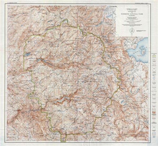
A fine example of Francois e. Matthes' 1930 topographical survey map of the spectacular Yosemite National Park, California. The map covers the entire park along with surrounding areas from Stanislaus National Forest to Mono Lake and the Mono National Forest. The map also features the boundary lines between Mariposa and Madera Counties and Tuolumne and Mono Counties. The Yosemite National Park limits are also marked. Throughout countless well known Yosemite sites are noted, including el Captain, eagles Pea, Mirror Lake, North Dome, Liberty Cap, and Half Dome as well as various other falls, peaks, trails, roads, mountain passes, meadows, lakes, rivers and creeks. Formed over millions of years of interaction between glaciers and rock, this U-shaped valley still undergoes dramatic changes with constant erosion, rock slides and avalanches. Located on the western slope of the Sierra Nevada Mountains and comprising of only 1% of the Yosemite National Park area, the Yosemite Valley is the most attractive and the most visited part of the park. The map is color coded with a legend on the right hand side of the map. This particular map was published as plate 2 by the United States Geological Survey in 1930 as part of the Geological History of the Yosemite Valley.
Cartographer
The Office of the Coast Survey (later the U.S. Geodetic Survey) (1807 - present), founded in 1807 by President Thomas Jefferson and Secretary of Commerce Albert Gallatin, is the oldest scientific organization in the U.S. Federal Government. Jefferson created the "Survey of the Coast," as it was then called, in response to a need for accurate navigational charts of the new nation's coasts and harbors. The first superintendent of the Coast Survey was Swiss immigrant and West Point mathematics professor Ferdinand Hassler. Under the direction of Hassler, from 1816 to 1843, the ideological and scientific foundations for the Coast Survey were established. Hassler, and the Coast Survey under him developed a reputation for uncompromising dedication to the principles of accuracy and excellence. Hassler lead the Coast Survey until his death in 1843, at which time Alexander Dallas Bache, a great-grandson of Benjamin Franklin, took the helm. Under the leadership A. D. Bache, the Coast Survey did most of its most important work. During his Superintendence, from 1843 to 1865, Bache was steadfast advocate of American science and navigation and in fact founded the American Academy of Sciences. Bache was succeeded by Benjamin Pierce who ran the Survey from 1867 to 1874. Pierce was in turn succeeded by Carlile Pollock Patterson who was Superintendent from 1874 to 1881. In 1878, under Patterson's superintendence, the U.S. Coast Survey was reorganized as the U.S. Coast and Geodetic Survey (C & GS or USGS) to accommodate topographic as well as nautical surveys. Today the Coast Survey is part of the National Oceanic and Atmospheric Administration or NOAA. More by this mapmaker...
Source
Matthes, F. E., Geologic History of the Yosemite Valley, (Washington, USGS) 1930.
Condition
Very good. Original fold lines visible. Blank on verso.