Digital Image: 1571 Camocio map of Zakynthos, Greece
Zante-camocio-1571_d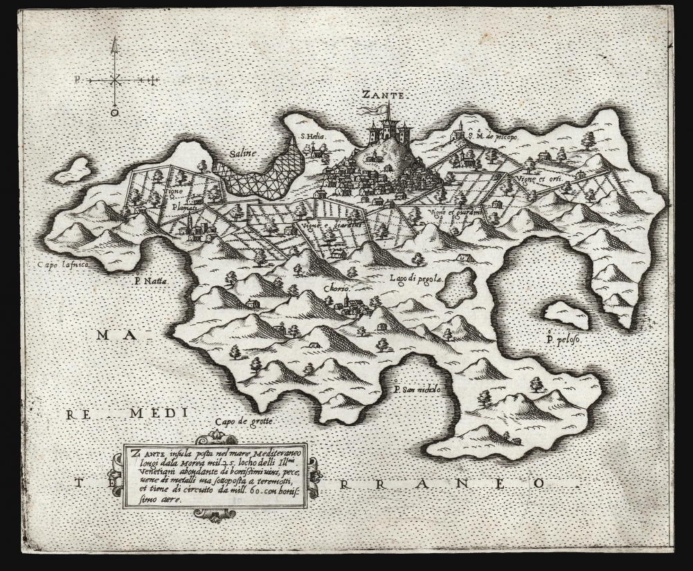

Title
Zante...
1571 (undated) 6.75 x 8.25 in (17.145 x 20.955 cm)
1571 (undated) 6.75 x 8.25 in (17.145 x 20.955 cm)
Description
FOR THE ORIGINAL ANTIQUE MAP, WITH HISTORICAL ANALYSIS, CLICK HERE.
Digital Map Information
Geographicus maintains an archive of high-resolution rare map scans. We scan our maps at 300 DPI or higher, with newer images being 600 DPI, (either TIFF or JPEG, depending on when the scan was done) which is most cases in suitable for enlargement and printing.
Delivery
Once you purchase our digital scan service, you will receive a download link via email - usually within seconds. Digital orders are delivered as ZIP files, an industry standard file compression protocol that any computer should be able to unpack. Some of our files are very large, and can take some time to download. Most files are saved into your computer's 'Downloads' folder. All delivery is electronic. No physical product is shipped.
Credit and Scope of Use
You can use your digial image any way you want! Our digital images are unrestricted by copyright and can be used, modified, and published freely. The textual description that accompanies the original antique map is not included in the sale of digital images and remains protected by copyright. That said, we put significant care and effort into scanning and editing these maps, and we’d appreciate a credit when possible. Should you wish to credit us, please use the following credit line:
Courtesy of Geographicus Rare Antique Maps (https://www.geographicus.com).
How Large Can I Print?
In general, at 300 DPI, you should at least be able to double the size of the actual image, more so with our 600 DPI images. So, if the original was 10 x 12 inches, you can print at 20 x 24 inches, without quality loss. If your display requirements can accommodate some loss in image quality, you can make it even larger. That being said, no quality of scan will allow you to blow up at 10 x 12 inch map to wall size without significant quality loss. For more information, it is best consult a printer or reprographics specialist.
Refunds
If the high resolution image you ordered is unavailable, we will fully refund your purchase. Otherwise, digital images scans are a service, not a tangible product, and cannot be returned or refunded once the download link is used.
Cartographer
Giovanni Francesco Camocio (Camozzi)(???? - c. 1575) was a Venetian cartographer, map publisher and printer. He was one of the most prolific of the so-called Lafreri school of Italian mapmakers in the second part of the sixteenth century. Little is known of Camocio's early years. His birthdate and place are not known. He is thought to have lived in Asola (near the Venetian fortress of Crema). In 1552 'Giovanni Francesco Camozzi' and his partners petitioned the Doge of Venice for a 15 year privilege for two books in progress, one a translation of a Greek medical text and the other a translation of Aristotle's Meteorology. The latter was published in 1556 by which time he was operating free of his unnamed partners. He would publish eleven more books until 1571, by which point he is known to have his own copper-plate printing shop. His output includes engravings of drawings and paintings by Titian, and various religious scenes. He is best known as a map printer, being among the Italian map publishers known collectively as the 'Lafreri' school (after Antonio Lafreri, the first of these to include a title sheet in his composite atlases.) The period between 1560 and 1575 resulted in Camocio's publication of no fewer than 36 large maps and many smaller format works. The end point of Camocio's production coincided with the plague which devastated Venice between 1574 and 1577. As there is no record relating to the man after 1575, it is very likely that he succumbed to the pestilence. More by this mapmaker...
References
OCLC 1233035489 ct. Bifolco, S. / Ronca, F. Cartografia e Topografia Italiana del XVI Secolo. Map 788 (second state). akharakis, C. G., A Catalogue of Printed Maps of Greece 1477-1800, #782.