1934 Karl Smith Map of the Life of Abraham Lincoln, Illinois, Indiana, Kentucky
AbrahamLincoln-karlsmith-1934$500.00

Title
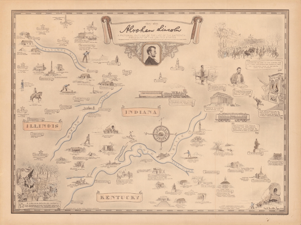
Abraham Lincoln, a pictorial outline of the life of the sixteenth president of the United States.
1934 (dated) 16.25 x 22 in (41.275 x 55.88 cm)
1934 (dated) 16.25 x 22 in (41.275 x 55.88 cm)
Description
A curious historical 1934 Karl Smith pictorial map of portions of Kentucky, Illinois, and Indiana, along with Washington, D.C. It traces the momentous life of Abraham Lincoln, from his childhood, to his presidency, through the Civil War, to his final resting place in Springfield, Illinois.
Another notable feature of the map is the labeling of locations where Lincoln and Stephen Douglas debated in their contest for one of Illinois' U.S. Senate seats in 1858. Though he lost to Douglas, Lincoln's performance in the debates made him a national figure, especially popular in the western states where his (somewhat embellished) image as a frontiersman garnered support and helped propel him to the Republican presidential nomination. He was initially less popular in the northeast, where abolitionism was strong, because he was seen as too moderate on the slavery issue (though he is remembered for ending slavery, Lincoln's position in the 1860 election was to prevent the spread of slavery to new states, not to abolish it in the South).
A Closer Look
Not drawn on a consistent scale, this pictorial map covers portions of Kentucky, Illinois, and Indiana ranging as far north as Chicago and south as Hodgenville, Kentucky, where Lincoln was born in 1809. Beginning with the migration of his grandfather and namesake into the region in 1782, events in the Great Emancipator's life are charted, including the Lincoln-Douglas Debates, his 1860 nomination as the presidential candidate of Republican Party, his March 1861 departure by train for his first inauguration, and finally to his burial in Springfield, Illinois. At right, Washington, D.C. is included to depict events from Lincoln's presidency, including the Emancipation Proclamation, the Gettysburg Address, and his assassination at the hands of John Wilkes Booth. Posthumous memorials in Springfield, Washington, D.C., and elsewhere are also illustrated, as are locations relevant to the life of his parents, siblings, and wife.The Land of Lincoln
Among the locations noted here, perhaps the most significant is Springfield, Illinois, where Lincoln lived for nearly 25 years between 1837 and 1861. He began his legal and political career in the city, and helped to get it designated as the state capital in 1839. After leaving Springfield to attend his inauguration, Lincoln would never return to the city alive. Following his assassination, Lincoln's funeral train returned his body to Springfield to be buried in Oak Ridge Cemetery.Another notable feature of the map is the labeling of locations where Lincoln and Stephen Douglas debated in their contest for one of Illinois' U.S. Senate seats in 1858. Though he lost to Douglas, Lincoln's performance in the debates made him a national figure, especially popular in the western states where his (somewhat embellished) image as a frontiersman garnered support and helped propel him to the Republican presidential nomination. He was initially less popular in the northeast, where abolitionism was strong, because he was seen as too moderate on the slavery issue (though he is remembered for ending slavery, Lincoln's position in the 1860 election was to prevent the spread of slavery to new states, not to abolish it in the South).
Publication History and Census
This map was drawn by Karl Smith in 1934, with historical data provided by John Speed of Louisville, Kentucky. Two printings of the map exist, one in black-and-white and one in color, as with the present example. It was republished in 1969, with a note indicating that John Speed was the son of Kentucky native James Speed, a lifelong friend of Lincoln who was appointed Attorney General of the United States in 1864. The 1934 edition of the map is noted among the holdings of eleven institutions in the OCLC.Cartographer
Karl J. Smith (August 28, 1895 - August 7, 1986) was an American cartographer and illustrator best known for his pictorial maps. Smith was born in Louisville, Kentucky. His first job was at Louisville Paper Company - where he apparently fell into a barrel of ink. He served in World War I (1914 - 1918). His earliest work dates to about 1934, when he was commissioned by the Speed Art Museum of Louisville, Kentucky to make pictorial maps of the states. It is unclear if he completed this project, but known maps include Kentucky, Indiana, Illinois, Ohio, Michigan, North Carolina, Arkansas, Mississippi, Florida, and California. There are likely others. Around 1950, he relocated to Greensboro, North Carolina, where he worked as advertising director for the Dillard Paper Company. Later, in the late 1950s, he issued a series of historical maps of the United States for Linweave Paper Company. Smith's style resembles that of Ernest Dudley Chase but is more playful and humorous. In addition to cartographic work, he was also considered an expert on heraldic painting. He was also an amateur historian and well-known expert on Benjamin Franklin. Smith died in Louisville, Kentucky, at 90. More by this mapmaker...
Condition
Very good. Minor creases near border.
References
Rumsey 8894.000, 13411.000 (alternate printing). OCLC 13775471.