This item has been sold, but you can get on the Waitlist to be notified if another example becomes available, or purchase a digital scan.
1595 Ortelius Map of Northern Abruzzo, Central Italy
Abruzzi-ortelius-1595$300.00

Title
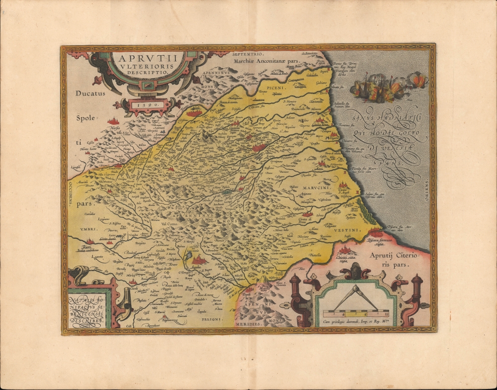
Aprutii Ulterioris Descriptio.
1595 (dated) 14 x 19 in (35.56 x 48.26 cm) 1 : 350000
1595 (dated) 14 x 19 in (35.56 x 48.26 cm) 1 : 350000
Description
A lovely old color example of Abraham Ortelius' map of the Abruzzo or Abruzzi region of central Italy that appeared in the 1595 Latin edition of his Theatrum Orbis Terrarum, the first modern atlas.
The Apennine Mountains are noted near center, along with other scattered hills and mountains; much of the land on the left side of the map is now protected as part of several national parks. At lower-left, Rieti is noted as the 'navel of Italy,' a popular nickname for the town which refers to its central location in Italy on both a north-south and east-west axis. Exquisite letter engraving is employed for the text labeling the Adriatic Sea and Gulf of Venice and in the attribution of the map that was the basis for the present one, by Natale Bonifacio (1538-1592), published in Rome in 1587. Fine cartouches surround this attribution, the title, and the scale at bottom-right. Latin text on the verso provides historical and geographic information about the region.
A Closer Look
Covering the area between the Tronto River (noted as the limit of the Kingdom of Naples) and the Fiume Pescara (Aterno-Pescara), this map takes in the northern half of the region of Abruzzo, historically known as Abruzzi, on the Adriatic coast of central Italy (the division of the region into Abruzzo Citra and Abruzzo Ultra dates to the 13th century). Included are most of the larger cities and towns in Abruzzo, such as L'Aquila, Teramo, Chieti, and Pescara, which are instantly identifiable despite some changes in spelling over the centuries. The gorgeous town of Ascoli Piceno, known for its Medieval and Renaissance towers, gates, bridges, and ornate piazzas, is evident near the cartouche at top.The Apennine Mountains are noted near center, along with other scattered hills and mountains; much of the land on the left side of the map is now protected as part of several national parks. At lower-left, Rieti is noted as the 'navel of Italy,' a popular nickname for the town which refers to its central location in Italy on both a north-south and east-west axis. Exquisite letter engraving is employed for the text labeling the Adriatic Sea and Gulf of Venice and in the attribution of the map that was the basis for the present one, by Natale Bonifacio (1538-1592), published in Rome in 1587. Fine cartouches surround this attribution, the title, and the scale at bottom-right. Latin text on the verso provides historical and geographic information about the region.
Naval Warfare Vignette
The battling ships at top-right, not present in Bonifacio's original, may refer to a specific naval battle, though, if so, Ortelius does not indicate which one. From the 15th to the 18th century, Venice frequently clashed with the Ottoman Empire in the Adriatic, though when not fighting they were robust trading partners. By the late 16th century, most of the fighting took place off the shores of Greece, including the consequential Battle of Lepanto in 1571, or otherwise outside the Adriatic. But the history of warfare between Venice and the Ottomans, and raids and incursions by the Ottomans along the Italian coast, would still loom large in the popular imagination. This history is also evident in the large number of fortified towers at regular intervals along the Adriatic.Publication History and Census
This map first appeared in the Theatrum in 1590, based on Bonifacio's 1587 map, and, being such a late addition, only appeared in one state in the entire history of the work. This example was printed for the 1595 Latin edition of the Theatrum (1595L84). In its various printings, this map is well-represented in institutional collections and occasionally appears on the market.Cartographer
Abraham Ortelius (April 14, 1527 - June 28, 1598) also known as Ortels, was a cartographer, geographer, and cosmographer of Brabant, active in Antwerp. He was the creator of the first modern atlas, Theatrum Orbis Terrarum and is a seminal figure in the history of cartography. Along with Gerard Mercator and Gemma Frisius, he was a founder of the Netherlandish school of cartography. His connections with Spain - culminating in his 1575 appointment as Royal Cartographer to King Phillip II of Spain - gave him unmatched access to Spanish geographical knowledge during a crucial period of the Age of Discovery. Ortelius was born in 1527 in Antwerp. In 1547 he entered the Antwerp Guild of Saint Luke as an illuminator of maps. He began trading in books, prints, and maps, traveling regularly to the Frankfurt book and print fair, where in 1554 he met Mercator. He accompanied Mercator on journeys throughout France in 1560 and it was at this time, under Mercator's influence, that he appears to have chosen his career as a scientific geographer. His first published geographic work appeared in 1564, an eight-sheet cordiform world map. A handful of other maps preceded the 1570 publication of the first edition of the Theatrum Orbis Terrarum, which would prove to be his life work. Appearing with but 53 maps in its first edition, Ortelius' work expanded with new maps added regularly. By 1592, it had 134 maps. Many of Ortelius' maps remained the standard for nearly a century. He traveled extensively, but his genius was as a compiler, locating the best informed maps on which to base his own. His contacts throughout Europe and extending even (via the Portuguese) to the Far East were formidable. Moreover, many of his maps were based on his own scholarship, particularly his historical works. His theories of geography were particularly ahead of his time with respect to the notion of continental drift, the possibility of which he mused on as early as 1596, and which would be proven correct centuries later.
In a sense his greatest achievement was his successful navigation of the religious and political violence endemic to his city throughout his adult life: The Dutch Revolt, or Eighty Years' War (1568 - 1648), fully embroiled Antwerp. Although outwardly and officially recognized as Catholic (Arias Montanus vouched for Ortelius' Catholic orthodoxy prior to his appointment as Royal Geographer), Ortelius was able to separate himself from the religious furor which characterized the war in the low countries. Ortelius showed a glimpse of himself in a letter to a friend, regarding humanist Justus Lipsius: 'I do not know whether he is an adherent of the Pope or a Calvinist, but if he has ears to hear, he will neither be one nor the other, for sins are committed on both sides'. Ortelius' own explorations of Biblical history in his maps, and the Christogram contained in his own motto, suggest him to be a religious man, but his abjuration of political religious authorities mark him as an individualist. His tombstone at St Michael's Præmonstratensian Abbey in Antwerp bears the inscription, Quietis cultor sine lite, uxore, prole. ('served quietly, without accusation, wife, and offspring.') More by this mapmaker...
Source
Ortelius, A., Theatrum Orbis Terrarum, (Antwerp: Plantin) 1595.
Abraham Ortelius' magnum opus, Theatrum Orbis Terrarum, was the world's first regularly produced atlas, which 'set the standards for later atlases . . . It was the first undertaking of its kind to reduce the best available maps to an uniform format.' (Koeman) A modestly-sized work of fifty-three maps in its first edition of May 1570, it was an immediate success: there were three further editions that year, and the work remained in print for a total of 32 editions, the last of which was 1641, well after its author's 1598 death. Ortelius added to his atlas constantly, and by 1595 the Theatrum contained 147 maps. Ortelius is renowned generally as an editor, and indeed much of the Theatrum is compiled from a variety of sources: in such cases, Ortelius was scrupulous in naming his sources. But Ortelius was also a mapmaker in his own right: many of his maps are a distillation of various sources into his own work, and there were many maps - particularly in his atlas of Biblical and ancient history Parergon - which were entirely Ortelius' work. In his role as an editor, Ortelius followed in the footsteps of Munster, whose Cosmographia was, until Ortelius, the best window on the world for the curious European reader. In terms of the artistry of his maps, Ortelius oversaw the first great flourishing of copperplate engraving in the service of cartography to occur in Northern Europe. Ortelius' work provided the model for the atlases of Mercator, Hondius, Blaeu and all their progeny in the 17th century - many of whom were to produce faithful editions of Ortelius' maps in their own productions.
Condition
Very good. Generous margins. Superb original color. Some toning along centerfold.
References
OCLC 551929717.