1814 Salt Map of Abyssinia: Ethiopia, Eritrea, Somalia, Djibouti
Abyssinia-salt-1814$950.00

Title
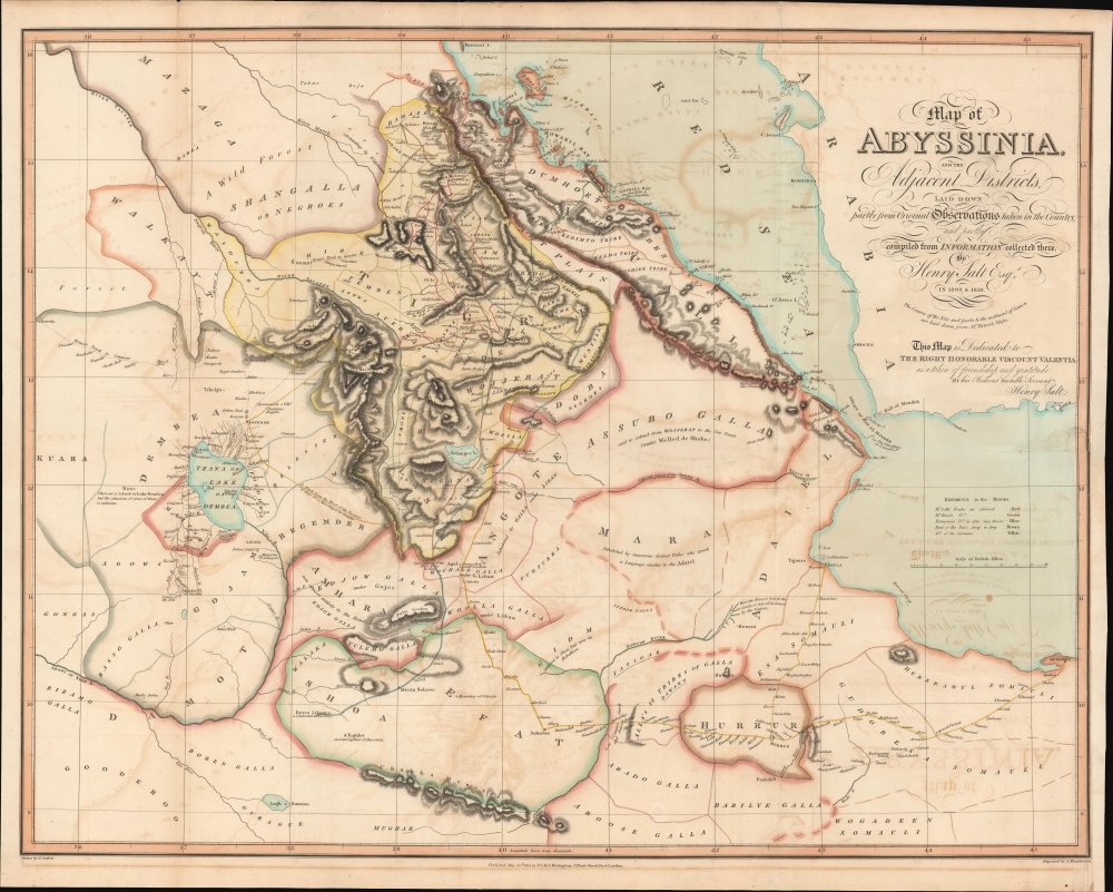
Map of Abyssinia and the adjacent districts laid down partly from original Observations taken in the Country and partly compiled from information collected there by Henry Salt Esq.
1814 (dated) 23 x 29.5 in (58.42 x 74.93 cm) 1 : 1520640
1814 (dated) 23 x 29.5 in (58.42 x 74.93 cm) 1 : 1520640
Description
A striking and important 1814 map of northern Abyssinia (Ethiopia) and surrounding territories by the English artist, diplomat, and Egyptologist Henry Salt. One of the earliest highly accurate European maps of the Tigrayan highlands, it appeared in Salt's A Voyage to Abyssinia and travels into the interior of that country.
Historical Context
Coverage includes what is now the northern part of Ethiopia, along with Eritrea, Djibouti, and the effectively independent state of Somaliland in northern Somalia. The map is especially detailed on the highlands of Tigray, where Salt spent several months in 1805 - 1806 on a British diplomatic mission to Wolde Selassie, the Ras (leading nobleman) of Tigray. Wolde Selassie befriended and made a deep impression on Salt, and on other contemporary British travelers to Tigray, such as Nathaniel Pearce, who accompanied Salt but stayed behind for several years in Tigray, and who regarded Wolde Selassie as something of a philosopher-king. Salt returned to Tigray in 1809 - 1810 on a second expedition, where he was met and escorted by Pearce.A Closer Look
Areas of elevation, rivers and lakes, settlements, roads (tracks), names of regions and local ethnic groups, historical notes, and more are indicated throughout. The route of Salt is traced in red, while other travelers' tracks (including Pearce, here as 'Pierce') are denoted with different colors. Hand-colored borders differentiate the major power players jostling for position within the disunified empire, led by a weak figurehead emperor. This period was the 'Era of Princes' (Zemene Mesafint), and Tigrayan nobles were among the most powerful forces in the empire.Publication History and Census
This map was drafted by Henry Salt and appeared in his 1814 book A Voyage to Abyssinia and travels into the interior of that country. It was drawn by John Outhett, engraved by Alexander Macpherson, and published in London by F.C. and J. Rivington. The map is dedicated to George Annesley, Viscount Valentia, whom Salt served as a secretary when making his first foray into Tigray. It is independently cataloged among the holdings of Harvard University, the University of California Berkeley, the British Library, the Bibliothèque nationale de France, and the Bayerische Staatsbibliothek, while the entire Voyage is more widely distributed.CartographerS
Henry Salt (June 14, 1780 - October 30, 1827) was a British artist, traveler, diplomat, and Egyptologist active in the first decades of the 19th century. Salt was trained as an artist and traveled extensively in Asia as secretary and draughtsman to George Annesley, the Veiscount Valentia. His first expedition, which lasted from about 1802 to 1806 involved travels to Cape Colony, the east coast of Africa, the Ethiopian Highlands, and India. His paintings from the expedition were published in Annelsey's 1809 Voyages and Travels to India. Afterwards Salt returned to Africa on a government sponsored mission to Ethiopia in the hopes of establishing diplomatic and trade relationships with the Tigrayan warlord Ras Wolde-Sillasie. Salt published the narrative of this expedition in his 1814 book A Voyage to Abyssinia, which also featured a collection of important maps. Today Salt is best known as an Egyptologist and collector of antiquities. In 1815 he was appointed British Consul-General in Cairo, where he dedicated himself to building a vast collection of Egyptian antiquities. Around this time, the ancient monuments and tombs of Egypt were a free-for-all for enterprising Europeans with a penchant for antiquities. Salt and other European adventurers, among them Italian Bernardino Drovetti, had hard reputations and were willing to stop at nothing to obtain choice pieces. Among Salt's top acquisitions are the head of Ramses II and the sarcophagus of Ramses III, located at the British Museum and the Louvre, respectively. Salt built three massive collections, each containing thousands of artifacts. Most of these pieces were acquired by the British Museum, where they rest to this day, though some did find their were to other institutions, such as the Louvre, and into various private collections. More by this mapmaker...
John Outhett (fl. c. 1809 - 1861) was an English artist and cartographer. He most often collaborated with the map publisher Richard Holmes Laurie. Learn More...
Alexander Macpherson (fl. c. 1806 - 1847) was a London-based engraver of maps in the early 19th century. Learn More...
Charles Rivington (1688 - 1742) was the founding member of the Rivington family of publishers. Starting out as a bookseller in 1736, he moved into publishing, scoring an early success with Samuel Richardson's novel Pamela, or Virtue Rewarded. When Charles Rivington died, the firm passed into the hands of his sons John (1720 - 1792) and James (1724 - 1802), the latter of whom emigrated to New York and published a well-known Loyalist newspaper called Rivington's Gazette during the American Revolution. John maintained the firm's emphasis on Christian literature and theological works, and passed the reins on to his sons Francis (1745–1822) and Charles (1754–1831). Several more generations of Rivingtons carried on the family business, which was eventually sold to Longman in the late 19th century. Learn More...
Source
Salt, H., A voyage to Abyssinia, and travels into the interior of that country..., (London: F.C. and J. Rivington) 1814.
Condition
Good. Some verso reinforcement along old fold lines. Right margin extended. Offsetting.
References
OCLC 57378714.