This item has been sold, but you can get on the Waitlist to be notified if another example becomes available, or purchase a digital scan.
1748 Anson Map of the Harbors of Acapulco and Manila - Mexico-Philippines
AcapulcoManila-anson-1748$225.00

Title
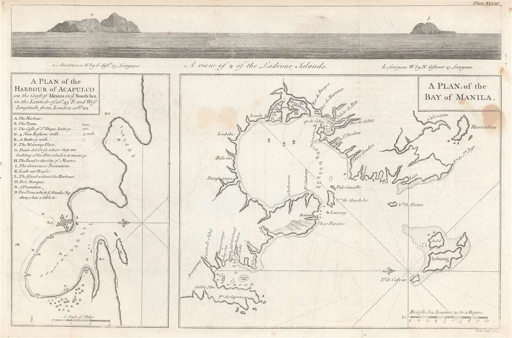
A plan of the harbour of Acapulco on the coast of Mexico in y'e South Sea, in the latitude of 16°45'N and west longitude from London 108°22' ;
A plan of the Bay of Manila.
1748 (undated) 10 x 15.25 in (25.4 x 38.735 cm) 1 : 110000
1748 (undated) 10 x 15.25 in (25.4 x 38.735 cm) 1 : 110000
Description
This attractive 1748 engraving includes charts of the harbors of Acapulco, Mexico and Manila in the Philippines, the two chief ports for Spanish galleons crossing the Pacific Ocean. They are accompanied, at the top, with a coastal view of the Ladrone Islands: these were the usual midway point for the route between the two charted ports. The map accompanied the 1748 volume describing George Anson's privateering voyage around the world, wherein Anson led eight ships on a mission to disrupt, capture and despoil Spain's holdings in the Pacific. As Acapulco and Manila were essential ports at each end of a Spanish Pacific voyage, the inclusion of these charts in Anson's work was essential. Despite two ships having to return home, and one ship - the Wager - succumbing to mutiny, Anson's venture was a success; he returned to wealth and acclaim.
The Marianas
The view, specifically of two of the Northern Marianas, shows coastal profiles of the island of Anatahan I(viewed west by south) and the island of Sarigan (viewed west by north.) Coastal views such as these were not purely decorative, but were considered essential navigational tools used for visual confirmation that a ship actually was where its navigator's instruments indicated it to be.Acapulco
The eastward-oriented chart is oriented to the east; A lettered key points out the locations of Acapulco's harbor, main town, its fortifications castle (Castle S. Diego and its 100 guns, and additional battery of 7, along with an a new fortification under construction). Depth soundings and important anchorages are noted as well.Manila
Also oriented to the east, the chart of Manila shows the city, spread out on three islands joined by a bridge. Several harbors are shown, both with soundings and anchorages.Publication History and Census
This map was engraved by Richard Seale for inclusion in Anson's 1748 A voyage round the world, in the years MDCCXL, I, II, III, IV. A French edition was produced in 1751. The separate map is only catalogued in the collections of Harvard, the Clements, and the National Libraries of Israel and Australia. Anson's Voyage is well represented in institutional collections.CartographerS
Baron George Anson (23 April 1697 - 6 June 1762) was a British commodore and a wealthy noble. Following Anson's aristocratic upbringing on the family estate of Shugborough in Sataffordshire, he joined the British Navy. Anson went through a series of rapid promotions and, in 1737, was given command of a fleet of six ships charged with the mission of attacking Spanish possessions in South America. This mission was ill-equipped and unprepared for the trials ahead. Storms and navigational errors took a heavy toll on the expedition. By the time Anson reached the island of Juan Fernandez his fleet had been diminished to only three ships and his crew reduced to roughly 1/3 of its original strength. Nonetheless, Anson's persistence eventually led to the capture of an immensely rich price, the Spanish treasure galleon Nuestra Senora de Covadonga. The galleon, taken off of Cape Espiritu Santo in 1743 was loaded with silver bullion and, more importantly, charts and maps detailing the routes between Mexico and the Far East used by the Spanish for over 200 years. Knowledge of this route enabled the British navy to disrupt Spanish trade in the Pacific and thus weaken its stranglehold on the Americas. Upon his return to England Anson was hailed as a national hero and made immensely wealthy by his share of the Nuestra's treasure. Anson retired from the Navy for a career in politics and was a Member of Parliament from 1744 to 1747. Anson subsequently continued his naval career with distinction as an administrator, becoming First Lord of the Admiralty (1757-1762). Seven British warships have borne the name HMS Anson in his honor. Anson County, North Carolina, and Ansonborough in Charleston, South Carolina, are also named in Anson's honor. More by this mapmaker...
Richard William Seale (December 1703 - May 25, 1762) was an English a mapmaker and engraver active in London during the middle part of the 18th century. Seale was the son of Richard and Elizabeth Seale. Richard, his father, was a member of the Stationers Company, suggesting that printing and engraving must have been a family trade. Nonetheless, he did not learn the trade from his father, but rather from Samuel Parker of Clerkenwell, to whom he was apprenticed in 1719. Seale was extremely active as an engraver and publisher from about 1740 until his death in 1762. His cartographic corpus is vast; including pieces engraved for most other notable English cartographers of his period: Willdey, Baron, Toms, Rocque, Basire, Bowles, Benning, among others. In addition to cartographic work, Seale also produce numerous architectural engravings. Learn More...
Source
Anson, George ,A voyage round the world in the years MDCCXL, I, II, III, IV, by George Anson. (London, Knapton) 1748.
Condition
Very good condition. Original folds but no wear. Faint offsetting. Margin reinstated at insertion point with no loss.
References
OCLC 223384036.