This item has been sold, but you can get on the Waitlist to be notified if another example becomes available, or purchase a digital scan.
1920 Johnson Official Guiggsberg Survey Map of Accra, Ghana (Gold Coast)
Accra-johnson-1920$1,250.00

Title
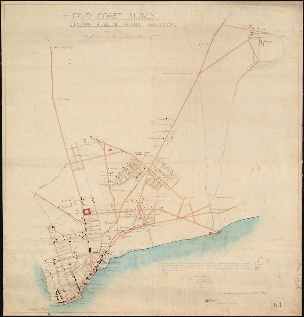
Gold Coast Survey General Plan of Accra (Provisional).
1920 (dated) 28 x 26.76 in (71.12 x 67.9704 cm) 1 : 10000
1920 (dated) 28 x 26.76 in (71.12 x 67.9704 cm) 1 : 10000
Description
An extraordinary find, what might be considered the founding document for modern Accra, capital of modern-day Ghana, at the apex of is colonial era prosperity. This map, a 'provisional survey' was issued in 1920, at the beginning of visionary Gold Coast governor, Sir Frederick Gordon Guiggsberg tenure. Coverage covers the heart of modern Accra from the Korle Lagoon east roughly as far as the old Dano-Norwegian city of Christianborg and Osu Castle, the old Fort Chrisiansborg. This is one of the earliest plans wherein the modern street grid begins to emerge, with major thoroughfares such as Kwame Nkrumah Ave, 28th February Road, and Independence Avenue recognizable.
On the Map
The city's commercial center, clustered at southern extreme peninsula is embraced by the Korli Lagoon and the Atlantic. Numerous named businesses, from warehouses and shipping firms to cacao traders, are noted. This district grew up around the 17th Century 'James Fort' and its neighboring 'Ussher Fort.' Under Guiggsberg it was further buttressed by the completion of rail routes, such as the Accra Akwapim and Harbour Works Railways. To the northeast, the newly instated government district appears in its infancy, with official buildings, the High Court, Police Barracks, the Secretariat, the Club House, hospitals, and a 'printing office' (likely where this map was produced). Additional new subdivisions appear as well, these are early suburbs designed for colonial civil servants. In the lower right, is the former Dano-Norwegian settlement of Christiansborg, with its old 'Osu Castle' appears.An Official Publication
This is an official map as is attested by the various signatures appearing at the bottom of the document. It was doubtless intended for early infrastructure work. Text in the lower right elaborates on the map's 'provisional' nature,An accurate survey of Accra on scales 1:1000 and 1:5000 is now in progress, and pending its completion this plan compiled from existing information is issued for public use. This plan does not claim to be exact in every detail but is produced to meet urgent needs while the accurate survey is carried out.Dispite its hasty nature and the claims of the makers, this map is in fact one of the most detailed and accurate records of Accra during the colonial period.
The Father of Modern Accra
Frederick Gordon Guiggsberg can rightly be considered the father of modern Accra. He was appointed colonial governor of the Gold Cost in 1919, a year before this important map was made. That a detailed survey like this appeared early in his tenure underscores his previous experience as a surveyor and engineer. Under Guiggsberg, Accra, which had long been neglected by the colonial offices, underwent a historic urban renewal, with modern streets, major infrastructure projects, a new deep-water harbor, hospitals, and the famous Achimota College, among other projects actively developed. Guggisberg's policies fostered the development of the city and country by and for its indigenous population rather by and for European colonial capitalists. He remained as governor of Accra until 1928, when he was reassigned to the struggling British Guiana. Unfortunately, he died at sea in 1929, less than one year after taking the South American post.Publication History and Census
This map is based upon survey work completed by J. T. Johnson and drafted by E. H. Allen, all under the supervision of R. H. Rowe (Surveyor General). This is a photographic printing to which contemporaneous color has been applied. The paper is slightly waxy, possibly a treatment intended to preserve it in the humid tropical climate. There are no other known examples - a once in a lifetime collecting opportunity.Condition
Very good. Minor repairs lower right. Light soiling.
References
Afriterra 3366 (this example, no image).