1717 Van Keulen Nautical Map of the Northern Aegean Sea and Bosphorus
AegeanNorth-vankeulen-1717$1,200.00


Title
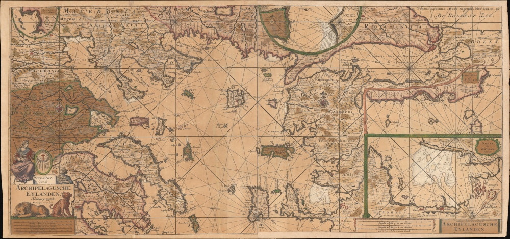
Paskaart Van de Archipelagusche Eylanden.
1717 (undated) 20 x 42.5 in (50.8 x 107.95 cm) 1 : 700000
1717 (undated) 20 x 42.5 in (50.8 x 107.95 cm) 1 : 700000
Description
An attractive old color c. 1717 Johannes van Keulen nautical chart or maritime map of the northern Aegean, Sea of Marmara, and the surrounding islands. Although critical to regional trade, the Aegean at this time was a hotbed of piracy - much associated with the ongoing Venetian-Ottoman War of 1714-1718.
This map was published in part III of Van Keulen's De Nieuwe Groote Lichtende Zee-Fackel.
A Closer Look
This dramatic sea chart covers from Macedonia and Thessalia eastward as far as the Bosporus Straits and the Black Sea. It extends south as far as Ephesus (Selçuk) on the Turkish Aegean. Inset maps detail the Gulf of Smyrna (Izmir), Chios (Scio), Schiro, and the Island of Tenedos. The lion in the cartouche symbolizes Venice, and its slumberous state is perhaps a commentary on that state's lackluster performance in defending Christianity. The map bears a 15-year Privilege, a kind of early copyright.Venetian-Ottoman War of 1714-1718
The Venetian-Ottoman War of 1714-1718, also known as the Seventh Ottoman-Venetian War, was primarily focused in the Aegean Sea and the Morea (Peloponnese peninsula in Greece). Sparked by the Ottoman Sultan Ahmed III's drive to regain territories lost to the Venetian Republic in earlier wars, the conflict began in 1714. The Ottomans, led by Ahmed III and Grand Vizier Damat Ali Pasha, launched a successful campaign in the Morea, recapturing the peninsula by 1715. Venice, weakened and unable to counter the Ottoman offensive, suffered significant losses, including the vital fortress of Nafplion. The war, marked by naval battles and sieges throughout the Aegean, stretched the resources of the Venetian Republic and highlighted the shifting balance of power in the eastern Mediterranean. The conflict eventually concluded with the Treaty of Passarowitz in 1718, where Venice ceded the Morea and a few Aegean islands but retained holdings in Dalmatia, marking a significant territorial reshuffle and a decline in Venetian influence.Publication History and Census
This map was issued in several editions. The individual sheets were designed to be either joined as a large chart, as here, or sold separately. Each sheet is separately titled, despite that title being the same. The map was first issued in the late 1680s and underwent several subsequent revisions. The present example has been updated over earlier editions with extensive inland detail.This map was published in part III of Van Keulen's De Nieuwe Groote Lichtende Zee-Fackel.
Cartographer
Johannes Van Keulen (1654 – 1715) was a Dutch cartographer active in Amsterdam during the late 17th century. Van Keulen was the son of Lucas van Keulen. Van Keulen's firm, ‘In de Gekroonde Lootsman' (In the Crowned Pilot), was founded in 1678 and registered with the Amsterdam bookseller's guild as 'Cross staff-maker and bookseller.' (The cross-staff is a nautical instrument used to determine latitude.) Two years later, in 1680, they obtained a patent from the States General of Holland and West Friesland to publish nautical charts and atlases. Together with his partner, the cartographer Claes Janz Vooght, Van Keulen published numerous atlases and nautical charts, including the Zee Atlas and Nieuwe Lichtende Zee-Fakkel. It was a massive five-volume atlas containing more than 130 nautical charts. The Zee-Fakkel established the Van Keulen firm as the pre-eminent maker of Dutch sea charts in the late 17th and early 18th century. In 1714, one year before Johannes Van Keulen's death, his son, Gerard van Keulen (1678 - 1726), took charge. Gerard continued to update and republish the Zee-Fakkel until his own death in 1726. The firm was later passed on to Gerard's son, Johannes II Van Keulen (1704 - 1755), who significantly updated the atlas, especially with regard to Asia, issuing the 1753 4th Volume, known as the 'Secret Atlas'. The final editions of the atlas were published by Gerard Hulst van Keulen (1733 - 1801), Joannes II's son. The final true Van Keulen edition of the Zee-Fakkel was published posthumously in 1803. It is noteworthy that though ostensibly controlled by the Van Keulen men, it was the Van Keulen widows who maintained and managed the firm in the periods following their husbands' deaths. After the death of Gerard Hulst Van Keulen's son, Johannes Hulst Van Keulen, ownership of the family plates and business fell into the hands of the Swart family, who continued to publish until the company closed its doors 1885, ending a cartographic legacy spanning nearly 207 years. More by this mapmaker...
Source
Van Keulen, J., De Nieuwe Groote Lichtende Zee-Fakkel, Part III, (Amsterdam) c. 1717.
Nieuwe Lichtende Zee-Fakkel was the premier Dutch nautical atlas of the late 17th and 18th century. First introduced in 1681, over the course of its more than 100 years in production, the Zee-Fakkel expanded to six volumes. The first five volumes were published in Amsterdam by Johannes van Keulen (1654 - 1715). His son, Gerard van Keulen (1678 - 1726), reissued it in several editions with minor updates.
Grandson, Johannes II van Keulen (1704 - 1755) expanded the atlas in 1753 with Volume VI, illustrating Asian waters. This was a revolutionary addition. For three generations the Van Keulen's were the official cartographers of the VOC (Vereenigde Oostindische Compagnie / United Dutch East India Company). Until 1753, to protect their long-standing trade monopoly, the VOC jealously guarded their hydrographic data on East Asian waters, refusing the allow charts to be printed and requiring oaths of secrecy from the Van Keulens (and Bleaus before them). This led to dangerously inaccurate often contradictory charts. Thus, in 1744 Jan Harmenszoon de Marre (1696 - 1763), the VOC's Amsterdam Examiner, was instructed to work with van Keulen to publish compile, compare, and resolve the VOC's hoard of jealously guarded manuscript charts of East Asian waters. Johannes II and de Marre published the sixth volume of the Zee-Fakkel, focusing on Asian waters - if only for internal VOC use.
This was likely an attempt to consolidate and improve the general hydrography. Previously, VOC charts in manuscript were disseminated to ship captains on an as-needed basis, to be returned upon a voyage's completion. They were rarely compared or amended. A study of several VOC manuscript charts issued between 1720 and 1760 reveal striking disparities, likely resulting either from the charts being updated or copied from earlier less accurate charts. Such led to avoidable navigational and thus trade risks. A printed nautical atlas, whose hydrography was built upon the most recent and up-to-date charts, reassessed by the greatest chartmaker of the age, was a natural solution.
The new atlas, ostensibly an extension (Volume VI) of the existing commercially issued Nieuwe Lichtende Zee-Fakkel, was intended only for VOC use, and so became known as the 'Secret Atlas'. The printing run was extremely small, and access tightly controlled. VOC ship captains navigating to the Far East were given a copy on departure and expected to return it in good condition on return. Even so, the maps of the 'Secret Atlas' were disseminated, perhaps by the van Keulen's themselves. We note evidence of 'secret' Dutch hydrography in charts of the English Pilot as well as in other Dutch charts. Nonetheless, original maps from 'Secret' Zee-Fakkel volume VI remain of the utmost rarity.The firm passed to great-grandson Gerard Hulst van Keulen (1733 - 1801) under whose imprint the final 1803 van Keulen edition was published posthumously.
Grandson, Johannes II van Keulen (1704 - 1755) expanded the atlas in 1753 with Volume VI, illustrating Asian waters. This was a revolutionary addition. For three generations the Van Keulen's were the official cartographers of the VOC (Vereenigde Oostindische Compagnie / United Dutch East India Company). Until 1753, to protect their long-standing trade monopoly, the VOC jealously guarded their hydrographic data on East Asian waters, refusing the allow charts to be printed and requiring oaths of secrecy from the Van Keulens (and Bleaus before them). This led to dangerously inaccurate often contradictory charts. Thus, in 1744 Jan Harmenszoon de Marre (1696 - 1763), the VOC's Amsterdam Examiner, was instructed to work with van Keulen to publish compile, compare, and resolve the VOC's hoard of jealously guarded manuscript charts of East Asian waters. Johannes II and de Marre published the sixth volume of the Zee-Fakkel, focusing on Asian waters - if only for internal VOC use.
This was likely an attempt to consolidate and improve the general hydrography. Previously, VOC charts in manuscript were disseminated to ship captains on an as-needed basis, to be returned upon a voyage's completion. They were rarely compared or amended. A study of several VOC manuscript charts issued between 1720 and 1760 reveal striking disparities, likely resulting either from the charts being updated or copied from earlier less accurate charts. Such led to avoidable navigational and thus trade risks. A printed nautical atlas, whose hydrography was built upon the most recent and up-to-date charts, reassessed by the greatest chartmaker of the age, was a natural solution.
The new atlas, ostensibly an extension (Volume VI) of the existing commercially issued Nieuwe Lichtende Zee-Fakkel, was intended only for VOC use, and so became known as the 'Secret Atlas'. The printing run was extremely small, and access tightly controlled. VOC ship captains navigating to the Far East were given a copy on departure and expected to return it in good condition on return. Even so, the maps of the 'Secret Atlas' were disseminated, perhaps by the van Keulen's themselves. We note evidence of 'secret' Dutch hydrography in charts of the English Pilot as well as in other Dutch charts. Nonetheless, original maps from 'Secret' Zee-Fakkel volume VI remain of the utmost rarity.
Condition
Good. Two sheets joined at center. Top remargined. Minor older repairs on verso. Color oxidized.
References
Van der Krogt, P. C. J., Koeman's Atlantes Neerlandici, (3 Vols), vol.IV, Keu 88.