This item has been sold, but you can get on the Waitlist to be notified if another example becomes available.
1967 Air Force Cambridge Map of the Atmosphere and the Solar System
AerospaceEnvironment-airforce-1967$125.00


Title
Aerospace Environment.
1967 (dated) 28.5 x 37 in (72.39 x 93.98 cm)
1967 (dated) 28.5 x 37 in (72.39 x 93.98 cm)
Description
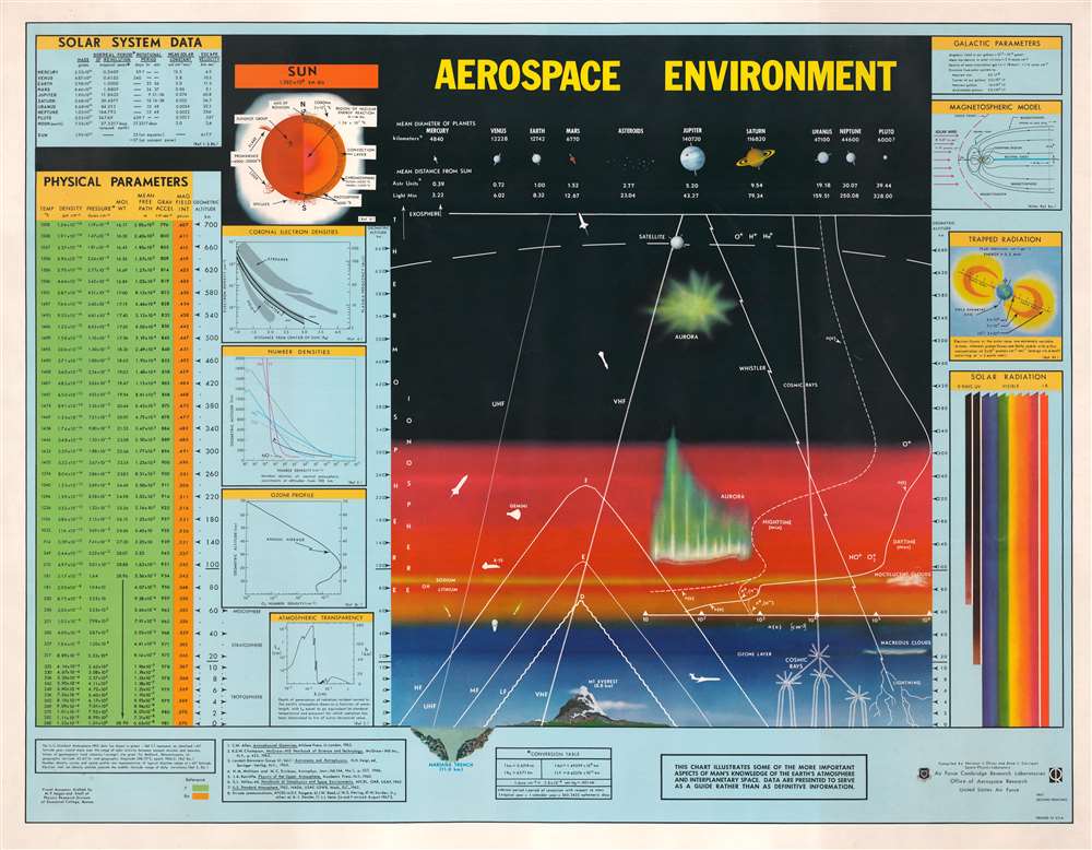
This is a 1967 Air Force Cambridge Research Laboratories map of the atmosphere and the Solar System. Compiled by Norman J. Oliver and Anne L. Carrigan, the map presents a cross-section of the Earth's atmosphere, identifying the thermosphere and ionosphere. Atmospheric phenomena, such as lightning, auroras, clouds, and the ozone layer are illustrated. As a means of providing scale, both the Mariana Trench (the deepest place in the ocean) and Mount Everest (the tallest mountain on Earth) appear along the bottom to illustrate the immensity of the atmosphere. A jet liner appears to the right of Mount Everest, and the X-15 and Gemini capsule is evident in the ionosphere. Rockets, missiles, and satellites also are illustrated and highlight the innovation of the Space Age. A chart illustrating the diameter of the planets and their average distance from the Sun is situated above a cross-section of the atmosphere. Information about solar radiation, the ozone profile, atmospheric transparency, and other areas of study are included to the left and right of the central cross-section.
The Air Force Cambridge Research Laboratories
The Air Force Cambridge Research Laboratories (AFCRL) was founded in September 1945 as the Cambridge Field Station. Its personnel were drawn from the Radiation Lab at M.I.T. and the Harvard Radio Research Laboratory. The lab became known as the AFCRL on July 4, 1949. It continued to grow and eventually comprised fourteen laboratories. The laboratories operated outside Cambridge, Massachusetts, until 2011, when they were consolidated to Wright-Patterson Air Force Base and Kirtland Air Force Base as the Air Force Research Laboratory.Publication History and Census
This map was compiled by Norman J. Oliver and Anne L. Carrigan of the Space Physics Laboratory and published by the Air Force Cambridge Research Laboratories in 1967. The present example comes from the second printing. Nine examples are cataloged in OCLC and are part of the collections at the Massachusetts Institute of Technology (M.I.T.), the Buffalo and Erie County Public Library, Ohio University, Calvin University, the University of Wisconsin-Madison, Auburn University, the University of Minnesota Minneapolis, the University of Texas, and Texas Tech University.Condition
Very good. Exhibits light wear along edges.
References
OCLC 22686364.