This item has been sold, but you can get on the Waitlist to be notified if another example becomes available, or purchase a digital scan.
1878 Kiepert Map of Eastern Afghanistan, Khyber Pass, Peshawar
Afghanistan-kiepert-1878$375.00

Title
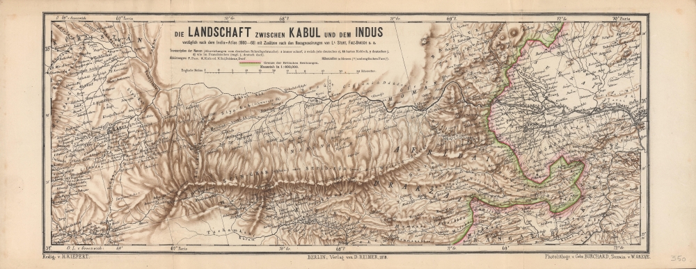
Die Landschaft zwischen Kabul und dem Indus.
1878 (dated) 9 x 22.5 in (22.86 x 57.15 cm) 1 : 600000
1878 (dated) 9 x 22.5 in (22.86 x 57.15 cm) 1 : 600000
Description
A scarce and highly detailed 1878 topographical map by Heinrich Kiepert of a portion of eastern Afghanistan and surroundings, highlighting the lands between Kabul and Peshawar. It was made as tensions between Britain and Afghanistan peaked, a side effect of the 'Great Game' competition between Britain and Russia, which led to the Second Anglo-Afghan War.
However, in July 1878, the Russians, who had recently expanded their empire to the border of Afghanistan, sent a diplomatic envoy to Kabul against the wishes of Sher Ali Khan, Amir of the Barakzai Dynasty. Nevertheless, the British demanded to send a similar mission, which the Amir rejected. When the British sent a delegation anyhow, the Afghans turned it back as it approached the Khyber Pass.
Britain responded with a multi-pronged invasion of Afghanistan in November 1878 that was much more successful than their previous foray. The Amir appealed to the Russians for assistance, but was rebuffed, and he died soon afterwards. His successor, Mohammad Yaqub Khan, signed an agreement which allowed British control of the emirate's foreign affairs and provided territorial concessions. However, the British presence set off a rebellion in September 1879 that lasted nearly a year. Feeling that their goals had been accomplished and considering the difficulty and cost of occupying the country led the British to withdraw all their troops by April 1881, leaving behind some officials to liaise with the Afghan government. Afghanistan was maintained as a semi-independent buffer between the Russian and British zones and, except for the 1885 Panjdeh Incident when Russian troops seized an Afghan border fort, afterwards the two empires did not approach a wider war over Afghanistan.
A Closer Look
Coverage runs along an axis from Kabul and its environs to Peshawar and its surroundings. Either due to its orientation (slightly to the northwest instead of due north) or its projection, this map appears to show Peshawar as due east of Kabul and Jalalabad as further north, when in fact both cities are to the south of a line running due east from Kabul. Settlements, rivers, and mountains (with elevation given in meters and English feet) are indicated throughout. A railway running to Peshawar, the Punjab Northern State Railway, only opened two years prior, is also signified. Longitude is noted using both the Greenwich and Paris Meridians, while scales are provided in English miles and kilometers.Historical Context
British interest in Afghanistan dated to the early 19th century, as Britain and Tsarist Russia looked to gain advantage over each other in Central Eurasia. However, Britain's first foray into Afghanistan (the First Anglo-Afghan War 1838 - 1842) was an abject disaster and ended with one of the worst defeats in British imperial history. Afghanistan was simply too difficult to invade and occupy given the terrain and effective resistance of Afghan warriors. Therefore, Afghanistan remained a solid buffer between the two empires as their competition ranged elsewhere.However, in July 1878, the Russians, who had recently expanded their empire to the border of Afghanistan, sent a diplomatic envoy to Kabul against the wishes of Sher Ali Khan, Amir of the Barakzai Dynasty. Nevertheless, the British demanded to send a similar mission, which the Amir rejected. When the British sent a delegation anyhow, the Afghans turned it back as it approached the Khyber Pass.
Britain responded with a multi-pronged invasion of Afghanistan in November 1878 that was much more successful than their previous foray. The Amir appealed to the Russians for assistance, but was rebuffed, and he died soon afterwards. His successor, Mohammad Yaqub Khan, signed an agreement which allowed British control of the emirate's foreign affairs and provided territorial concessions. However, the British presence set off a rebellion in September 1879 that lasted nearly a year. Feeling that their goals had been accomplished and considering the difficulty and cost of occupying the country led the British to withdraw all their troops by April 1881, leaving behind some officials to liaise with the Afghan government. Afghanistan was maintained as a semi-independent buffer between the Russian and British zones and, except for the 1885 Panjdeh Incident when Russian troops seized an Afghan border fort, afterwards the two empires did not approach a wider war over Afghanistan.
The Second Anglo-Afghan War (1878 – 1880)
The Second Anglo-Afghan War was fought between the British Raj and the Emirate of Afghanistan, which was ruled by Sher Ali Khan. Split between two campaigns, the first took place between November 1878, when the British invaded Afghanistan, and May 26, 1879, when the Afghans and British signed the Treaty of Gandamak. The second campaign was instigated by the murder of Sir Louis Cavagnari, the British representative in Kabul, and his guards. The fighting began with the October 6, 1879 defeat of the Afghan Army at Charasiab by the Kabul Field Force under Sir Frederick Roberts. Roberts occupied Kabul two days later and made camp at the Sherpur Cantonment. The Sherpur Cantonment was a British military encampment established during the Second Anglo-Afghan War and the site of the 1879 Siege of the Sherpur Cantonment by Afghan forces under Mohammed Jan Khan Wardak. The siege took place between December 15 and December 23, 1879, with the goal of overthrowing the British puppet Emir Mohammad Yaqub Khan and replacing him with the anti-British Mohammed Jan Khan Wardak. Jan's forces outnumbered the British and initially posed a significant threat to the fortified British cantonment. Nonetheless, British officers were able to appeal for rapid reinforcement. When news of an incoming British relief column reached Mohammad Jan, he made a desperate bid, storming the cantonment. Jan's assault was repulsed, and, fearing the relief force, the Afghan army dispersed. Any armed Afghan subsequently found in the area was hunted and killed. The Sherpur Cantonment has survived to the present day as a British cemetery. Yaqub Khan was forced to abdicate, and, after some indecision, the British installed his cousin Abdur Rahman Kahn as a puppet emir. Enraged, Ayub Khan, Yaqub's brother, led a revolt in Herat and defeated a British detachment at the July 1880 Battle of Maiwand, then proceeded to besiege Kandahar. In response, Roberts led the main British force out of Kabul and defeated Ayub Khan at the September 1 Battle of Kandahar, officially ending the war. Abdur Rahman Kahn confirmed the Treaty of Gandarmak, which granted the Afghans British protection and a subsidy in exchange for ceding Britain territory and control over Afghan foreign policy.The Great Game - the struggle for Afghanistan
From 1830 until 1895, a political and diplomatic confrontation, known as 'The Great Game', existed between the British Empire and the Russian Empire over Afghanistan and other territories in Central and Southern Asia. Illustrating a flashpoint region during an era steeped in distrust and the constant threat of war, this map is expressive of the undeniable undercurrent of hostility that pervaded the region. 'The Great Game', as it is known, was ignited due to Russian fears that Britain was making commercial and military inroads in Central Asia, while Britain mutually feared Russia adding 'the jewel in the crown' (India) to its vast empire in Asia. Several wars were fought, including the First Anglo-Afghan War in 1838, the First Anglo-Sikh War in 1845, the Second Anglo-Sikh War in 1848, and the Second Anglo-Afghan War in 1878, along with the Russian annexations of Khiva, Bukhara, and Kokand. Per historians, the Great Game ended on September 10, 1895, with the signing of the Pamir Boundary Commission protocols, which defined the border between Afghanistan and the Russian Empire - but well into the 20th century the British were well aware the conflict remained. Regarding the attitude of Afghans to the British and to the Russians, the general assumption of the British was that 'Some will fight for us, some against us, but all will fight.'Publication History and Census
This map was drawn by Heinrich Kiepert, photolithographed by the firm Burchard Gebrüder, with terrain added by Wilhelm Greve, and was published in 1878 by Dietrich Reimer. Based on the subtitle, Kiepert drew on several sources in compiling this map. It is held by the University of Chicago Library, the British Library, and the Staatsbibliothek zu Berlin, and has no known history on the market.CartographerS
Heinrich Kiepert (July 31, 1818 - April 21, 1899) was a German cartographer and historian active in the mid to late 19th century. Kiepert was born into generous circumstances that allowed him to develop his childhood interest in geography and history into a serious profession. The Berlin-born Kiepert traveled widely in his youth, and was encouraged in his studies by the historian Leopold von Ranke, a family friend. He was a student of classical antiquity under August Meineke and worked with Cal Ritter. He studied history, philology, and geography at the Humboldt University of Berlin - he would eventually teach geography there, and would remain there until his death. Disappointed with the poor quality of maps in historical school books, Kiepert set out to correct the problem. His first major work, the Atlas von Hellas und den hellenischen Kolonien, was published with Karl Ritter in 1840. The work immediately won accolades from the academic community. A number of similar publications followed, including the 1848 Historisch-geographischer Atlas der alten Welt, the 1854 Atlas Antiquus, and the 1894 Formae Orbis Antiqui. Kiepert specialized in the historical geography of the classical world at the University of Berlin. This developed into a geographical interest in the Ottoman Empire - which at the time was poorly mapped. He traveled to Asia Minor four times between 1841 and 1848, using his travels to collect and compile geographical data, producing several outstanding regional maps with wide-ranging coverage extending from the Mediterranean to the Caucasus. Thanks in large part to these works, Kiepert became the recognized expert on Ottoman geography, his works representing the best obtainable reconnaissances of their respective regions. From 1845 until 1852, Kiepert served as the head of the Geographisches Institut in Weimar. In 1854 he took a position as professor of Geography at the University of Berlin and for nearly 50 years was considered the go-to man with regard to the cartography of classical and biblical antiquity. Kipert formed a long-lasting professional association with Dietrich Reimer, a publisher in Berlin. Kiepert's maps are known for b being clear, easy to read, and as accurate as possible for the time in which they were produced. In addition to his landmark work in mapping the Ottoman Empire, Kiepert also published the first detailed ethnic maps of Austria-Hungary, the Balkan Peninsula, and Germany. Kiepert died in Berlin on April 21 of 1899. More by this mapmaker...
Dietrich Arnold Reimer (May 13, 1818 - October 15, 1899) was a German publisher. Born in Berlin, Reimer was the son of Georg Andreas Reimer (1776 - 1842), another German printer. He founded a book and map shop in 1845 in Berlin, and after taking over most of the art and geographic publishing from his father two years later, founded Dietrich Reimer Verlag. Heinrich Kiepert (1818 - 1899) began working for his publishing firm in 1852, and in 1868, Reimer made Hermann August Hoefer, a German bookseller, a partner in his company. This move pushed Reimer's publishing firm to international prominence, as the new partnership increased their desire to produce globes and their commitment to improving their maps. He married Henriette Hirzel in 1847, with whom he had three children. Henriette died in 1853, and Reimer remarried in 1855 to Emma Jonas. Reimer gave up control of his publishing house on October 1, 1891, due to health concerns, and the business passed to investor Ersnt Vohsen (1853 - 1919). The firm published under the imprint of 'Dietrich Reimer (Ernst Vohsen)' until Vohsen's death in 1919. Until the end of the World War I (1914 - 1818) and the Treaty of Versailles, the publishing house profited from the colonialism of the German Empire with this business model. It survived both the end of the war and inflation. It was able to recover by the start of World War II (1939 - 1945) but then had to cut back production again, mainly due to a shortage of paper and reduced demand. In April 1945, the publishing house at Wilhelmstrasse 29, including the archive, accounting department, and book warehouse, was destroyed in two air raids. It recovered and is today a prominent German academic publisher. The firm remains in operation today as 'Dietrich Reimer GmbH.' Learn More...
Burchard Gebrüder (fl c. 1866 - 1881), or Burchard Brothers, were a German photolithography and publishing firm that specialized in representing terrain on topographical maps. Little is known about the firm and its members aside from its rather limited output. Learn More...
Wilhelm Greve (? - 1883) was a German lithographer and publisher of maps and books, perhaps the father of a lithographer of the same name who was born in 1878 and died in 1932. Not much information is available about either man. A 'Geographisches Institut Wilhelm Greve' was established in Berlin in the early 1870s. The abbreviation 'Königl.' that often followed their name suggests that they published for the royal family (Hohenzollern). They continued to publish maps until the late 1920s. Learn More...
Condition
Very good. Even toning. Slight wear along fold line at left.
References
OCLC 86224538, 557751501, 557835636.