This item has been sold, but you can get on the Waitlist to be notified if another example becomes available, or purchase a digital scan.
1848 Walker Map of Afghanistan during the Great Game
Afghanistan-walker-1848$800.00

Title
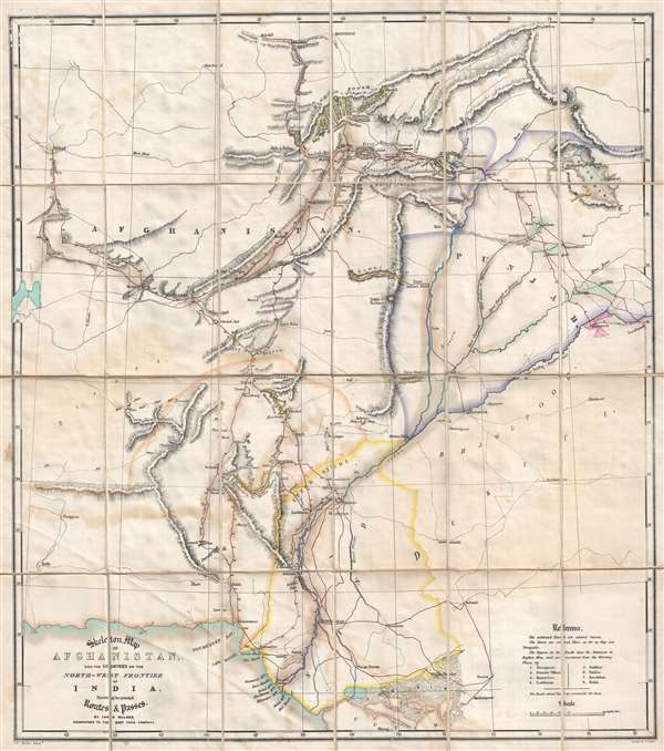
Skeleton Map of Afghanistan, and the Countries on the North-West Frontier of India, Shewing the principal Routes and Passes.
1848 (undated) 28.5 x 25.5 in (72.39 x 64.77 cm) 1 : 2100000
1848 (undated) 28.5 x 25.5 in (72.39 x 64.77 cm) 1 : 2100000
Description
This is a rare 1848 John Walker map of Afghanistan illustrating the 'Great Game' wherein colonial powers jostled for control of Central Asia in a series of conflicts. Published in the years following the First Anglo-Afghan War, the map depicts the region from Herat to Islamabad and Lahore, Pakistan and Firozpur (Ferozpoor), India and from Balkh and Kunduz (Koondooz), Afghanistan to the Kutch (Cutch) District in Gujarat, India.
The Great Game - the struggle for Afghanistan
From 1830 until 1895, a political and diplomatic confrontation, known as 'The Great Game', existed between the British Empire and the Russian Empire over Afghanistan and other territories in Central and Southern Asia. Illustrating a flashpoint region during an era steeped in distrust and the constant threat of war, this map is expressive of the undeniable undercurrent of hostility that pervaded the region. For example, roads, 'practicable for guns,' are identified.
'The Great Game', as it is known, was ignited due to Russian fears that Britain was making commercial and military inroads in Central Asia, while Britain mutually feared Russia adding 'the jewel in the crown' (India) to its vast empire in Asia. Several wars were fought, including the First Anglo-Afghan War in 1838, the First Anglo-Sikh War in 1845, the Second Anglo-Sikh War in 1848, and the Second Anglo-Afghan War in 1878, along with the Russian annexations of Khiva, Bukhara, and Kokand. Per historians, the Great Game ended on September 10, 1895 with the signing of the Pamir Boundary Commission protocols, which defined the border between Afghanistan and the Russian Empire.
Prepared by John Walker, numerous key locations throughout the region are labeled, including Kabul (Kabool), Kandahar, Quetta, Hyderabad, and Karachi (Kurrachee). Roads, rivers, mountain ranges (including the Hindu Kush), and mountain passes are illustrated and labeled. Most of the roads are illustrated in red ink, which, per a note in the reference situated in the lower right corner, are 'practicable for guns'. If it is not recommended to transport guns on a road, it is represented by a thin black line, instead of a comparatively large red one.
This map was published by John Walker in 1848. There are at least two editions, the present example, 1848, and a second edition issued in 1850. The OCLC identifies only three examples held in institutional collections at the British Library, the Bibliothèque Nationale de France, and at Yale University.
Cartographer
John Walker (1787 - April 19, 1873) was a British map seller, engraver, lithographer, hydrographer, geographer, draughtsman, and publisher active in London during the 19th century. Walker published both nautical charts and geographical maps. His nautical work is particularly distinguished as he was an official hydrographer for the British East India Company, a position, incidentally, also held by his father of the same name. Walker's maps, mostly published after 1827, were primarily produced with his brothers Charles Walker and Alexander Walker under the imprint J. and C. Walker. Among their joint projects are more than 200 maps for the influential Society for the Diffusion of Useful Knowledge Atlas (SDUK). In addition they published numerous charts for James Horsburgh and the British Admiralty Hydrographic Office, including Belcher's important map of Hong Kong and Carless' exploratory map of Karachi. The J. and C. Walker firm continued to publish after both Walkers died in the 1870s. More by this mapmaker...
Condition
Very good. Dissected into 24 sections and mounted on linen. Light transferrence. Blank on verso. Accompanied by original case.
References
OCLC 494422737.