This item has been sold, but you can get on the Waitlist to be notified if another example becomes available, or purchase a digital scan.
1842 Wyld map of Afghanistan, Pakistan, India and Iran
Afghanistan-wyld-1842-3$1,000.00

Title
Map of
Afghaunistan, Caubul, the Punjab, Rajpootana, and the River Indus
1842 (undated) 22.75 x 31 in (57.785 x 78.74 cm) 1 : 2816000
1842 (undated) 22.75 x 31 in (57.785 x 78.74 cm) 1 : 2816000
Description
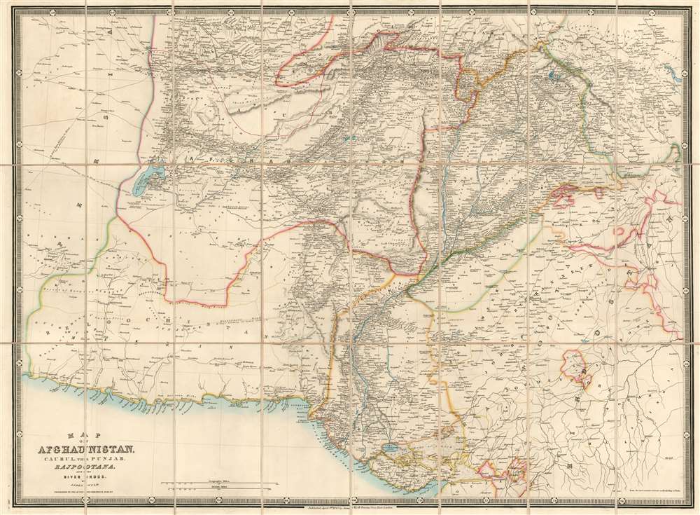
This is an 1842 Wyld map of Afghanistan and its surrounds, showing the theatre of the First Anglo-Afghan War: the first major conflict of ‘The Great Game’ for British control of India. It was printed just three months after the disastrous Retreat from Kabul. Though the debacle is not specifically referred to on the map, the passes between Kabul and Peshawar are shown with sufficient detail (surpassing other contemporaneous maps of the area ) that it seems clear that the map reflects the best British understanding of Afghanistan’s geography at the time of the conflict. These include Gandamak - the pass approaching Jalalabad in which the massacre of Elphinstone's army took place between January 6 and January 13, 1842.
Scope of the Map
The map extends from the Gulf of Oman and the Arabian Sea northwards to Hindu Kush: it reaches from the deserts of eastern Iran and reaches Delhi, Agra, and Pangong Tso In the Himalayas. The whole of the map is detailed, but the Indus River Valley and the area between that river and the Hindu Kush are shown with particular granularity.Northwestern India
The map shows what is now Gujarat, Rajasthan, Haryana, and Himachal Pradesh. Many cities and the roads connecting them are clearly marked, with hand color delineating the borders between the provinces. Among many others, the cities of Delhi, Agra, Jaisalmer, Jodhpur, Ahmedabad, and Bikaner are named.The Theater of War
The geographical spread of what the British refer to as The Disaster in Afghanistan can be found here. All the major cities where actions occurred are shown, with the roads connecting them well detailed: Quetta, Kandahar, Ghazni, Qalat, Kabul and Jalalabad all are shown along with the neighboring villages, passes, and roads. Though the scope of this map is larger than the contemporaneous SDUK maps of Afghanistan, the detail is far sharper and undoubtedly reflects details that were derived from the military action taking place in 1839 and 1840.Sikh States
Northwest of Delhi, the modern regions of Punjab and Chandigarh are named 'Sikh States.' This was the Sikh Empire, who until 1837 had been at war with the Emirate of Afghanistan.Iran
The western portion of the map - marked as Persia, and Beloochistan further to the south - shows the desert regions of eastern Iran. As with most large desert regions in the 19th century, there is little fine detail here: but routes off the map are labeled ('18 days from Kirman to Herat for a horseman'... '36 days journey from Yezd to Doosha for laden camels.' 'Mountainous road 13 days for laden camels'The Great Game - the struggle for Afghanistan
From 1830 until 1895, a political and diplomatic confrontation, known as 'The Great Game', existed between the British Empire and the Russian Empire over Afghanistan and other territories in Central and Southern Asia. 'The Great Game', as it is known, was ignited due to Russian fears that Britain was making commercial and military inroads in Central Asia, while Britain mutually feared Russia adding 'the jewel in the crown' (India) to its vast empire in Asia. Several wars were fought, including the First Anglo-Afghan War in 1838, the First Anglo-Sikh War in 1845, the Second Anglo-Sikh War in 1848, and the Second Anglo-Afghan War in 1878, along with the Russian annexations of Khiva, Bukhara, and Kokand. Per historians, the Great Game ended on September 10, 1895 with the signing of the Pamir Boundary Commission protocols, which defined the border between Afghanistan and the Russian Empire.Publication History and Census
This map is rare. The map has appeared dealers’ catalogues only six times going back to 1978. OCLC shows examples held by only the Bibliotheque Nationale, Durham University, the University of Minnesota, the University of Nebraska, and the University of Melbourne.Cartographer
Wyld (1823 - 1893) was a British publishing firm active throughout the 19th century. It was operated by James Wyld I (1790 - 1836) and his son James Wyld II (November 20, 1812 - 1887) were the principles of an English mapmaking dynasty active in London during much of the 19th century. The elder Wyld was a map publisher under William Faden (1749 - 1836) and did considerable work on the Ordinance Survey. On Faden's retirement in 1823, Wyld took over Faden's workshop, acquiring many of his plates. Wyld's work can often be distinguished from his son's maps through his imprint, which he signed as 'Successor to Faden'. Following in his father's footsteps, the younger Wyld joined the Royal Geographical Society in 1830 at the tender age of 18. When his father died in 1836, James Wyld II was prepared to fully take over and expand his father's considerable cartographic enterprise. Like his father and Faden, Wyld II held the title of official Geographer to the Crown, in this case, Queen Victoria. In 1852, he moved operations from William Faden's old office at Charing Cross East (1837 - 1852) to a new, larger space at 475 Strand. Wyld II also chose to remove Faden's name from all of his updated map plates. Wyld II continued to update and republish both his father's work and the work of William Faden well into the late 1880s. One of Wyld's most eccentric and notable achievements is his 1851 construction of a globe 19 meters (60 feet) in diameter in the heart of Leicester Square, London. In the 1840s, Wyld also embarked upon a political career, being elected to parliament in 1847 and again in 1857. He died in 1887 following a prolific and distinguished career. After Wyld II's death, the family business was briefly taken over by James John Cooper Wyld (1844 - 1907), his son, who ran it from 1887 to 1893 before selling the business to Edward Stanford. All three Wylds are notable for producing, in addition to their atlas maps, short-run maps expounding upon important historical events - illustrating history as it was happening - among them are maps related to the California Gold Rush, the New South Wales Gold Rush, the Scramble for Africa, the Oregon Question, and more. More by this mapmaker...
Condition
Excellent condition. Dissected and mounted on linen for folding, as issued. Original covers removed but present.
References
OCLC 39156794.