This item has been sold, but you can get on the Waitlist to be notified if another example becomes available, or purchase a digital scan.
1662 Jansson/ Blanckaert Map of Africa during the Reign of Hadrian
Africa-blanckaert-1662$600.00

Title
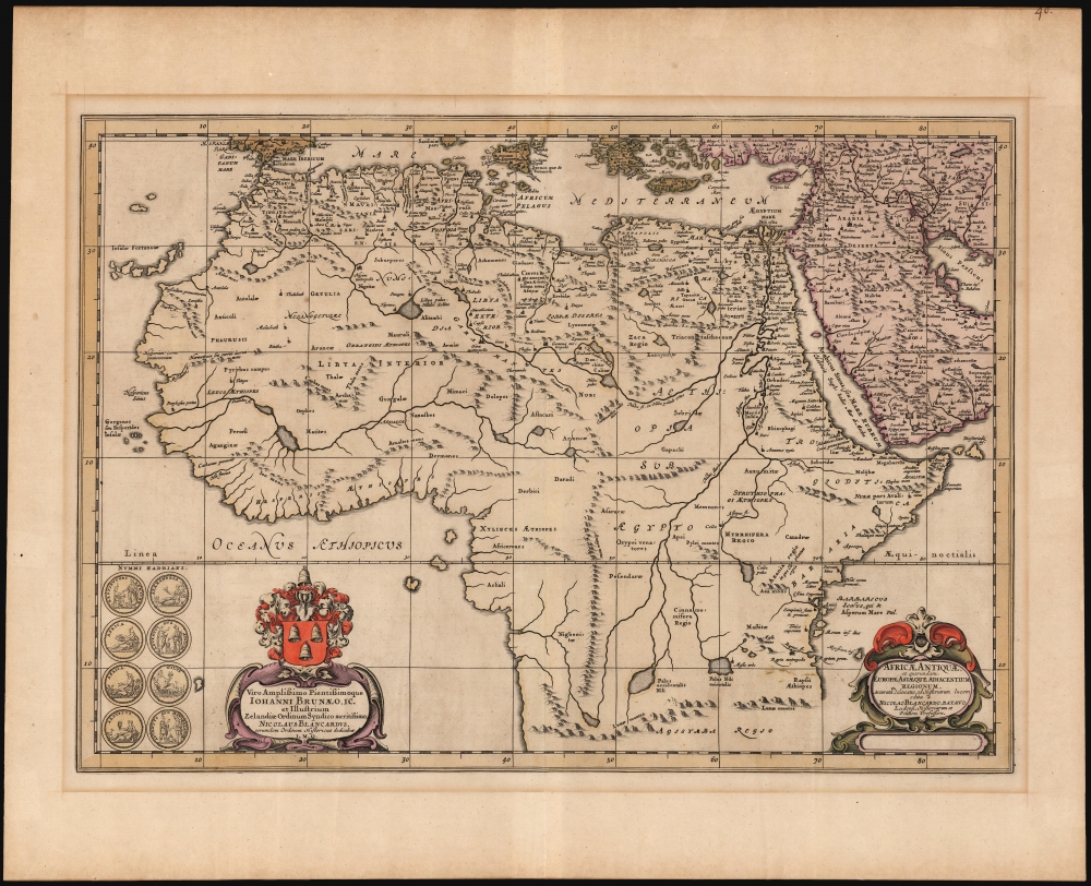
Africae Antiquae et quarundam Europae Asiaeque Adiacentium Regionum, accuratra delineatio ad Historiarum lucem edita Nicolao Blancaerdo Batavo.
1662 (undated) 14.75 x 20.75 in (37.465 x 52.705 cm) 1 : 18500000
1662 (undated) 14.75 x 20.75 in (37.465 x 52.705 cm) 1 : 18500000
Description
This is Nicolaas Blanckaert's historical map of Africa, drawn for the final volume of Jansson's Atlas Novus, which was dedicated to maps illustrating ancient and Biblical history. Blanckaert was a deeply respected historian and philologist, and his contribution to the atlas would have granted it great authority; this consisted of a trio of maps of Roman-era Europe, Asia and the present Africa map.
A Closer Look
The map presents the continent of Africa from approximately 18° South to 40° North: that is, from about the latitude of modern-day Zimbabwe, to the Mediterranean Sea. In its embrace of Africa from the Cape Verde islands to Socotra, it also includes most of the Arabian Peninsula and the Fertile Crescent. The map's topology is consistent with Mercator's world map of 1569, particular in its presentation of rivers. Its presentation of mountains is novel, and more sparing. The map's toponymy is ancient, at least in part drawn from Ptolemy, but the ancient place names are arranged according to more contemporary geographical ideas. The cartographer's goal appears to have been to make the reports of the ancients consistent with modern exploration. Blanckaert certainly in some places draws on earlier sources still. For example, in the region of Libya the description of the kingdom of Cinyps as 'the sweetest and most fertile land in all of Africa' is a direct quote from the 5th century BCE historian Herodotus.An Elegant Engraving
The maps produced by Jansson in the latter part of the 17th century were the aesthetic match of those of his competitor, Blaeu. Mountains are shown in profile pictorially, and the map's lettering is clear and legible. A shell-motif cartouche appears in the lower right; the dedicatory cartouche to Dutch scholar and statesman Johan de Brune (1588 - 1658) is surmounted by a beautiful coat of arms. To the lower left are the versi of eight ancient coins from the reign of Emperor Hadrian. These had been minted in Rome, in commemoration of Hadrian's tour of the Empire. The 'heads' of these coins depicted the Emperor in profile; the versi or 'tails' faces contained allegorical figures and the names of the Imperial provinces for which the coins were dedicated (Alexandria, for example, or the Nile, or Egypt, or Mauretania.) The coins may have actually been distributed by the Emperor in the areas to which they were dedicated. Blanckaert had published important translations of early histories of Rome, and the coins surviving from Hadrian's reign represented important corroborations for his historians' often questionable reports.Publication History and Census
This map was engraved for inclusion in the 1662 edition of Jansson's Atlas Novus; it is consequently one of the scarcest of the Jansson atlas maps, having been included in only a handful of printings of Jansson's work. The present example, with no verso text, corresponds to the printing of the map for inclusion in the 1700 edition of Hornius' Description of the Earth, or Ancient Geography, both Sacred and Profane. Nine examples of the separate map are listed in OCLC; one example from a 1702 French edition of the work is so listed. The map is scarce on the market.CartographerS
Jan Jansson or Johannes Janssonius (1588 - 1664) was born in Arnhem, Holland. He was the son of a printer and bookseller and in 1612 married into the cartographically prominent Hondius family. Following his marriage he moved to Amsterdam where he worked as a book publisher. It was not until 1616 that Jansson produced his first maps, most of which were heavily influenced by Blaeu. In the mid 1630s Jansson partnered with his brother-in-law, Henricus Hondius, to produce his important work, the eleven volume Atlas Major. About this time, Jansson's name also begins to appear on Hondius reissues of notable Mercator/Hondius atlases. Jansson's last major work was his issue of the 1646 full edition of Jansson's English Country Maps. Following Jansson's death in 1664 the company was taken over by Jansson's brother-in-law Johannes Waesberger. Waesberger adopted the name of Jansonius and published a new Atlas Contractus in two volumes with Jansson's other son-in-law Elizée Weyerstraet with the imprint 'Joannis Janssonii haeredes' in 1666. These maps also refer to the firm of Janssonius-Waesbergius. The name of Moses Pitt, an English map publisher, was added to the Janssonius-Waesbergius imprint for maps printed in England for use in Pitt's English Atlas. More by this mapmaker...
Nicolaas Blanckaert (1624 - 1703) was a Dutch philologist, historian, and professor. Although his immediate family is known, virtually nothing is known of his background and education. Is father, Stefan Blanckaert, was a schout (sheriff). While he is little known now, during his lifetime he was a prolific and respected author, editor and scholar. He published a broad array of translations from the Greek, including in 1683 Harpocration's Lexicon, the first published translation of that work (virtually the only lexicon of ancient Greek oratory to survive.) By 1662 he was professor of history and politics in Leiden, and was a historian for the Order of Zeeland. He would in 1669 become professor of Greek at the University of Franeker, a position he probably held until his death in that city. Learn More...
Source
Hornius, G., Description of the Earth, or Ancient Geography, both Sacred and Profane, (Amsterdam: Janssonius van Waesberghe) 1700.
Condition
Very good. Some toning and mat burn, else excellent with original color.
References
OCLC 774072095. Not in Norwich.