1748 Bowen Map of Africa
Africa-bowen-1748$750.00
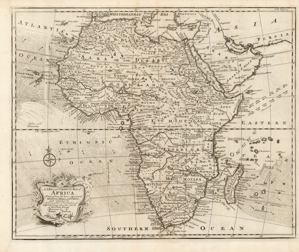

Title
A New and Correct Map of Africa Drawn from the most Approved Modern Maps and Charts, and adjusted by Astronomical Observations, representing also the course of the Trade Winds Monsoons etc. By Eman. Bowen 1748.
1748 (dated) 14.5 x 17.75 in (36.83 x 45.085 cm) 1 : 26000000
1748 (dated) 14.5 x 17.75 in (36.83 x 45.085 cm) 1 : 26000000
Description
This is Emanuel Bowens' updated 1748 map of Africa. It depicts the continent in rich detail, particularly with respect to indigenous peoples, kingdoms, fortifications, and mines. It is not an amendment of the 1747 Bowen map of the continent, but an entirely new plate, and while it shares many characteristics of the earlier map, there is matter that is entirely new to it.
Most apparently, Bowen has included in the south Atlantic and the Indian Oceans the prevailing winds, and the directions of the seasonal monsoon winds. These were of particular relevance to ships sailing from Europe to India and were derived from the maps of the trade winds produced at the end of the seventeenth century by William Dampier.
The 1747 map had included a speculative proto-Lake Malawi, identified as Lake of Zambre. The present map removed that long, thin lake - perhaps because it was not consistent with the new presentation of the Zambezi River which replaced the 'Cuamo' on the earlier map. Both formulations appeared on different maps of De l'Isle. These and many other details in Bowen's map appear to be derived from John Senex' Africa : corrected from the observations of the Royal Society at London and Paris, which had been printed as early as 1710 but was still in production in the 1740s.
Most apparently, Bowen has included in the south Atlantic and the Indian Oceans the prevailing winds, and the directions of the seasonal monsoon winds. These were of particular relevance to ships sailing from Europe to India and were derived from the maps of the trade winds produced at the end of the seventeenth century by William Dampier.
Egypt and Abyssinia
Northeastern Africa from the Mediterranean shores to the Horn appears in detail - not just the region of the lower Nile (where, for example, the Pyramids are named and depicted) but also Abyssinia (modern-day Ethiopia). The upper reaches of the Blue Nile present the detail gathered at the end of the seventeenth century by early Italian missionaries. Bowen correctly notes the course of the Blue Nile placing its source at Lake Tana (here Dambea) in modern day Ethiopia.Nations and Tribes
This map offers significant detail throughout the interior, naming numerous tribal areas and kingdoms including the Jages, the Anziko, the Mono-Emugi, Monomotapa, Gaoga, Gingiro, and others. Many of these names survive from reports from the seventeenth and even the sixteenth century. It is a testament to the paucity of European data for the African interior that so many of these had no more recent improvements.Monomotapa and the Zambezi
The southern region of Africa - generally classified here as 'Cafereria' - is dominated by the Empire of Monomotapa. The interest in the place is made plain by the presence of gold and silver mines. At the heart of this empire runs the Zambezi River. This river is not new to this map, but on earlier maps (including the 1747 Bowen) it is most often termed Cuama. This was a local name for the river given by Swahili speakers on the coast. As early as 1552, the Portuguese João de Barros had known that the river was termed Zembere by the Monomatapa. João dos Santos, visiting Monomatapa in 1597, named it Zambeze. Earlier maps had put its source in a vast lake. Here its source is not identified although a lake nearby seems to be a holdover from the earlier formulation. Recorded exploration of the upper Zambezi would not occur until Livingstone's expedition between 1851 and 1853.The 1747 map had included a speculative proto-Lake Malawi, identified as Lake of Zambre. The present map removed that long, thin lake - perhaps because it was not consistent with the new presentation of the Zambezi River which replaced the 'Cuamo' on the earlier map. Both formulations appeared on different maps of De l'Isle. These and many other details in Bowen's map appear to be derived from John Senex' Africa : corrected from the observations of the Royal Society at London and Paris, which had been printed as early as 1710 but was still in production in the 1740s.
Publication History and Census
This map was engraved by Emanuel Bowen for inclusion in John Harris' 1748 Navigantium atque itinerantium bibliotheca : or, A complete collection of voyages and travels. It is underrepresented in institutional collections, being listed separately only twice in OCLC. Harris' voyages is well represented in library collections.CartographerS
Emanuel Bowen (1694 - May 8, 1767) had the high distinction to be named Royal Mapmaker to both to King George II of England and Louis XV of France. Bowen was born in Talley, Carmarthen, Wales, to a distinguished but not noble family. He apprenticed to Charles Price, Merchant Taylor, from 1709. He was admitted to the Merchant Taylors Livery Company on October 3, 1716, but had been active in London from about 1714. A early as 1726 he was noted as one of the leading London engravers. Bowen is highly regarded for producing some of the largest, most detailed, most accurate and most attractive maps of his era. He is known to have worked with most British cartographic figures of the period including Herman Moll and John Owen. Among his multiple apprentices, the most notable were Thomas Kitchin, Thomas Jeffreys, and John Lodge. Another apprentice, John Oakman (1748 - 1793) who had an affair with and eventually married, Bowen's daughter. Other Bowen apprentices include Thomas Buss, John Pryer, Samuel Lyne, his son Thomas Bowen, and William Fowler. Despite achieving peer respect, renown, and royal patronage, Bowen, like many cartographers, died in poverty. Upon Emanuel Bowen's death, his cartographic work was taken over by his son, Thomas Bowen (1733 - 1790) who also died in poverty. More by this mapmaker...
John Senex (1678 - 1740) was an English engraver and map maker active in London during the first half of the 18th century. Senex was born to upper middle class parents in Shropshire, England. As a young man, he was apprenticed to Robert Clavell, a London bookseller and member of the Stationers' Company, under whom he mastered the arts of engraving and printmaking. Around 1702 Senex completed his apprenticeship and established himself as a printer and bookseller in the Strand. A year later Senex partnered with Jeremiah Seller and Charles Price, the successors to the important mapmaker John Seller, and relocated to Cornhill. This was likely Senex's first introduction to mapmaking though he seems to have taken to it with abandon. In the subsequent years Senex established himself as one of the most prominent cartographers in London, publishing a number of beautiful and important maps that today rank among the finest examples from the Golden Age of British Cartography. In addition to a large corpus of flat maps, Senex also produced a number of important and highly desirable globes. Eventually Senex dissolved his partnership with Seller and Price and relocated to Fleet Street, where he maintained offices until his death in 1740. Senex was succeeded by his widow, Mary Senex, who continued to publish and update his works until about 1755, when the remaining globe and map plates were sold to James Ferguson. Learn More...
Source
Harris, J., Navigantium atque itinerantium bibliotheca : or, A complete collection of voyages and travels, (London) 1748.
Condition
Excellent. Right margin close to platemark but complete; fine overall.
References
OCLC 702564546. Norwich, O. Norwich's Maps of Africa #89.