
This item below is out of stock, but another example (left) is available. To view the available item, click "Details."
Details
1835 Bradford Map of Northern Africa
1835 (undated) $150.00
1835 Bradford Map of Africa
Africa-bradford-1835$75.00

Title
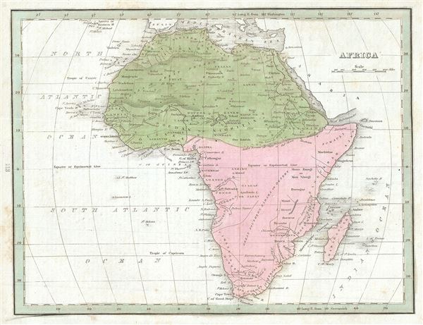
Africa.
1835 (undated) 8.5 x 10.5 in (21.59 x 26.67 cm) 1 : 46000000
1835 (undated) 8.5 x 10.5 in (21.59 x 26.67 cm) 1 : 46000000
Description
An interesting example of the 1835 map of Africa by the important American mapmaker T. G. Bradford. This is an early 19th century and historically important representation of the continent of Africa. Nineteenth century mapmakers were particularly challenged by the difficult task of deciphering Africa. Despite a fairly constant flow of information about the continent dating to the middle ages, much of the interior remained speculative at best. Bradford chooses to leave most of the interior blank and instead focuses known areas, or more precisely, areas perceived to be known. These include Mediterranean North Africa, Egypt, Abyssinia, the western Niger valley, the Congo, South Africa, and the lands of Mozambique and Monomotapa (Zimbabwe).
Each of these regions have their own unique history of European contact. Egypt, along the Nile, had been well mapped even in antiquity. The same is true of Christian Abyssinia which, through regular contact with the Coptic mother church in Egypt and Portuguese missionaries, was well known, if mostly unexplored by Europeans. The tale of European incursion and occupation of South Africa could easily encompass volumes and explains Bradford's sophisticated mapping of this region. The Niger Valley and the Congo had been simultaneously exploited and explored by Portugal and later Belgium since the 1300s.
Monomotapa, opposite the island of Madagascar, was a major stopping point on the Portuguese trade routes to India. Curiously this region has also been associated with King Solomon's Mines and Biblical legends of the Land of Ophir. Bradford identifies Monomotapa, which by this time had long fallen into decline. He also identifies several of its constituent states including Manica, Sabia, and Sofala.
The remaining parts of the map are frequently quite vague. Bradford does note several important and recognizable African tribal groups including the Hottentots, the Tibboos, the Tuaricks, and others. North of the Monomotapa region we can find Lake Maravi, a long narrow lake oriented on a north-south axis. This lake most likely represents Lake Malawi or Lake Tanganyika, or both. The Ptolemaic Mountains of the Moon are drawn stretching across the central part of the continent with the suggestions that they are the source of several branches of the Nile.
At the time this map was made, the slave trade, thriving since the 5th century was rapidly diminishing due to decreased demand for slaves in the New World, the British outlawing of slavery in 1808, and subsequent diplomatic efforts including treaties with over 50 African rulers outlawing the practice. Many African economies adapted by shifting to the export of mineral and agricultural resources, which led to the European scramble for territory, occupying most of the continent by the end of the 19th century. Europe's colonial interests in Africa haphazardly carved up the continent into unnatural territories, often forcing historic enemies into close proximity and leading to social problems that remain to this day.
The map was published as plate no. 113 in Thomas G. Bradford's 1835 Comprehensive Atlas Geographical, Historical and Commercial. Bradford's atlas, published in 1835 was an important work on many levels. First, it was one of the first American atlases to follow an encyclopedic format, offering readers extensive geographical and statistical tables to supplement the maps themselves. Second, it was published in Boston and influenced the city's rise as a publishing center later in the 19th century (at the time most publishing in the United States was restricted to New York and Philadelphia). Third, this atlas was the first to contain a separate and specific map showing the Republic of Texas. Fourth and finally, Bradford's atlas in some instances broke the Euro-centric mold regarding atlas production. Among other things, Bradford focused his atlas on the Americas and abandoned the classical decoration common in European atlases in favor of a more informational and inherently American approach.
Bradford published this atlas in several editions and with various partners. The first edition was published by William D. Ticktor and did not contain the iconic Republic of Texas map (although we have in fact seen Ticktor examples with a Texas map, suggesting, against conventional wisdom, that there may have been two Ticktor editions). The second official edition, published in the same year by the American Stationers Company, was the first to contain the Republic of Texas map, which is based on Austin's map, with two pages of descriptive text. A third edition was issued in 1836, also by American Stationers (though still dated 1835), and contained an unaltered Republic of Texas map with only a single page of descriptive test. A fourth edition appeared later, possibly 1837, and included an updated and revised map of Texas that replaces the old Mexican land grants with new inchoate counties. The maps from this atlas are an important addition to any collection focusing on early American cartography and Republic of Texas cartography.
All maps in this atlas, though not specifically noted as such, were most likely engraved by G. W. Boynton of Boston, who also engraved most of the maps for Bradford's later publication.
CartographerS
Thomas Gamaliel Bradford (1802 - 1887) was born in Boston, Massachusetts, where he worked as an assistant editor for the Encyclopedia Americana. Bradford's first major cartographic work was his revision and subsequent republishing of an important French geography by Adrian Balbi, Abrege de Geographie published in America as Atlas Designed to Illustrate the Abridgment of Universal Geography, Modern and Ancient. Afterwards Bradford revised and expanded this work into his own important contributions to American cartography, the 1838 An Illustrated Atlas Geographical, Statistical and Historical of the United States and Adjacent Countries. Bradford's cartographic work is significant as among the first to record Texas as an independent nation. In his long career as a map publisher Bradford worked with William Davis Ticknor of Boston, Freeman Hunt of New York, Charles De Silver of Philadelphia, John Hinton, George Washington Boynton, and others. We have been able to discover little of Bradford's personal life. More by this mapmaker...
George Washington Boynton (fl. c. 1830 - 1850) was a Boston based cartographer and map engraver active in the first half of the 19th century. Boynton engraved and compiled maps for numerous publishers including Thomas Bradford, Nathaniel Dearborn, Daniel Adams, and S. G. Goodrich. His most significant work is most likely his engraving of various maps for Bradford's Illustrated Atlas, Geographical, Statistical, and Historical, of the United States and the Adjacent Countries and Universal Illustrated Atlas. He also engraved for the Boston Almanac. In 1835, Boynton is listed as an employee of the Boston Bewick Company, an engraving, stereotype, and printing concern based at no. 47 Court Street, Boston. Little else is known of his life. Learn More...
Source
Bradford, T. G., A Comprehensive Atlas Geographical, Historical and Commercial (Boston), 1835.
Condition
Very good. Original platemark visible. Minor spotting at places. Blank on verso.
References
Rumsey 2643.123 (1838 edition).