1849 Greenleaf Map of Africa
Africa-greenleaf-1849$200.00

Title
Africa.
1849 (undated) 10.75 x 12.5 in (27.305 x 31.75 cm) 1 : 31000000
1849 (undated) 10.75 x 12.5 in (27.305 x 31.75 cm) 1 : 31000000
Description
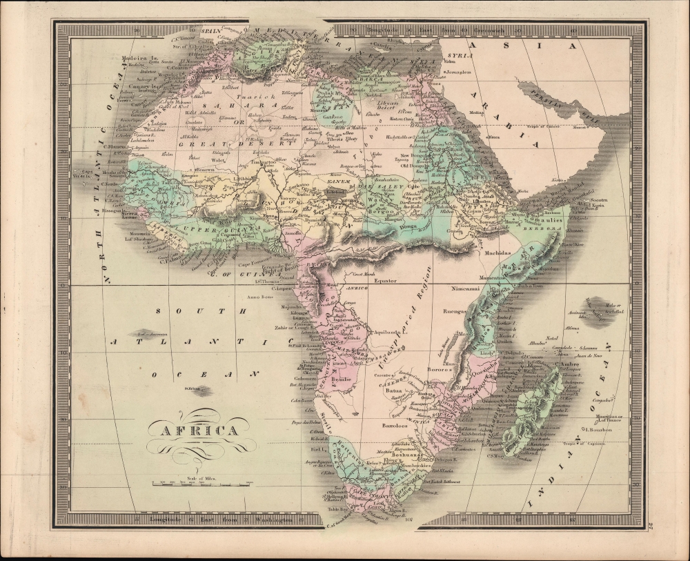
An example of Jeremiah Greenleaf's hand-colored 1849 map of Africa, from his New Universal Atlas, reflecting the limited but developing European understanding of African geography.
Each of these regions has a unique history of European engagement. Egypt, along the Nile, was well-mapped even in antiquity. The same is true of Christian Abyssinia which, through regular contact with the Coptic mother church in Egypt and Portuguese missionaries, was well known, if mostly unexplored by Europeans. The tale of European incursion and occupation of South Africa could easily encompass volumes and explains Greenleaf’s sophisticated mapping of this region. The Niger Valley and the Congo had been simultaneously exploited and explored by Portugal since the 1400s.
Mozambique was a major stopping point on the Portuguese trade routes to India. Curiously, this region has also been associated with King Solomon's Mines and Biblical legends of the Land of Ophir. Greenleaf identifies several of its constituent regions, including Sabia, Botanga, and Sofala.
The remaining parts of the map are vague. North of Mozambique we can find the embryonic mapping of 'Lake Maravi,' most likely representing Lake Malawi, or possibly Lake Tanganyika, or both. The Ptolemaic Mountains of the Moon are drawn stretching across the central part of the continent with the suggestion that they are the source of several branches of the Nile. Compared to Burr's original (see 'Publication History and Census' below), Greenleaf has maintained the basic form but provided updates, removing some speculative and outdated elements while adding in new details (caravan routes across the Sahara, for instance).
A Closer Look
Nineteenth century mapmakers were particularly challenged by the difficult task of deciphering Africa. Despite a constant flow of information about the continent dating to the Middle Ages, much of the interior remained speculative. Greenleaf chooses to leave much of the continent blank, and instead focuses on known areas, or more precisely, areas perceived to be known. These include Mediterranean North Africa, Egypt, Abyssinia (Ethiopia), the western Niger Valley, the Congo, South Africa, and the lands of Mozambique and Zimbabwe.Each of these regions has a unique history of European engagement. Egypt, along the Nile, was well-mapped even in antiquity. The same is true of Christian Abyssinia which, through regular contact with the Coptic mother church in Egypt and Portuguese missionaries, was well known, if mostly unexplored by Europeans. The tale of European incursion and occupation of South Africa could easily encompass volumes and explains Greenleaf’s sophisticated mapping of this region. The Niger Valley and the Congo had been simultaneously exploited and explored by Portugal since the 1400s.
Mozambique was a major stopping point on the Portuguese trade routes to India. Curiously, this region has also been associated with King Solomon's Mines and Biblical legends of the Land of Ophir. Greenleaf identifies several of its constituent regions, including Sabia, Botanga, and Sofala.
The remaining parts of the map are vague. North of Mozambique we can find the embryonic mapping of 'Lake Maravi,' most likely representing Lake Malawi, or possibly Lake Tanganyika, or both. The Ptolemaic Mountains of the Moon are drawn stretching across the central part of the continent with the suggestion that they are the source of several branches of the Nile. Compared to Burr's original (see 'Publication History and Census' below), Greenleaf has maintained the basic form but provided updates, removing some speculative and outdated elements while adding in new details (caravan routes across the Sahara, for instance).
Historical Context
At the time this map was made, the slave trade, thriving since the 5th century was rapidly diminishing due to decreased demand for slaves in the New World, the British outlawing of slavery in 1808, and subsequent diplomatic efforts including treaties with over 50 African rulers outlawing the practice. Many African economies adapted by shifting to the export of mineral and agricultural resources, which led to the European scramble for territory, occupying most of the continent by the end of the 19th-century and haphazardly carving it up.Publication History and Census
This map was published by Jeremiah Greenleaf in the scarce 1849 (last) edition of his New Universal Atlas. It is based on David Burr's 1834 original, which was published in the latter's atlas of the same name, before being inherited and updated by Greenleaf, who published it in several editions in the 1840s.CartographerS
Jeremiah Greenleaf (1791 - 1864) is a little known but highly admired American cartographer of the early 19th century. He published from roughly 1830 to 1850. His most important work is A New Universal Atlas; Comprising of all the Principal Empires, Kingdoms, and States Throughout the World and Forming a distinct Atlas of the United States, published in several editions in the 1840s. Many of his maps are reformatted versions of his contemporary David Burr's much admired cartographic works. Greenleaf's maps are extremely rare and admired for their stunningly vivid pastel color washes. More by this mapmaker...
David Hugh Burr (August 18, 1803 - December 25, 1875) of one of the first and most important truly American cartographers and map publishers. Burr was born in Bridgeport Connecticut in August of 1803. In 1822 Burr moved to Kingsboro, New York to study law. A year and a half later he was admitted to the New York Bar association. Burr must have questioned his choice of careers because shortly after being admitted to the Bar, he joined the New York State Militia. Though largely untrained in the art of surveying, Burr was assigned to work under Surveyor General of New York, Simeon De Witt, to survey several New York Roadways. Seeing a window of opportunity, Burr was able to negotiate with the governor of New York at the time, De Witt Clinton, to obtain copies of other New York survey work in order to compile a map and Atlas of the state of New York. Recognizing the need for quality survey work of its territory, the government of New York heartily endorsed and financed Burr's efforts. The resulting 1829 Atlas of the State of New York was the second atlas of an individual U.S. state and one of the most important state atlases ever produced. Burr went on to issue other maps both of New York and of the United States in general. In cooperation with publishing firm of Illman & Pillbrow, he produced an important New Universal Atlas and, with J.H. Colton, several very important maps of New York City. In recognition of this work, Burr was appointed both "Topographer to the Post office" and "Geographer to the House of Representatives of the United States". Later, in 1855, Burr was assigned to the newly created position of Surveyor General to the State of Utah. Burr retired from the position and from cartographic work in general in 1857 when light of some of his financial misdeeds and frauds came to light. He was accused of submitting false expense reports and underpaying employees, among other indiscretions. Learn More...
Source
Greenleaf, J., New Universal Atlas, (Brattleboro, Vermont: Greenleaf) 1849.
Condition
Very good. Light soiling.
References
Rumsey 15176.031.