1707 J. B. Homann Africa (First Plate)
Africa-homann-1707$850.00

Title
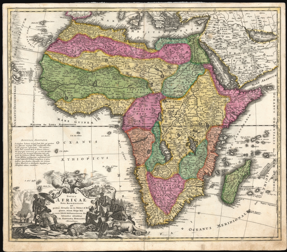
Totius Africae Nova Repraesentatio.
1707 (undated) 19.25 x 22.5 in (48.895 x 57.15 cm) 1 : 19000000
1707 (undated) 19.25 x 22.5 in (48.895 x 57.15 cm) 1 : 19000000
Description
This is the scarce first plate of Johann Baptist Homann's 1707 map of Africa in a beautiful early strike, with rich, original color. Here, Homann attempts to reconcile the discovery of Lake Tana in Abysinna (source of the Blue Nile) with established Ptolemaic geography - and, in doing so, commits a grave error!
Homann's model for Tana also appears to draw loosely on Eschinardi's bean-shaped model. Its placement, however, is unlike any other map we have encountered. DuVal, Coronelli, and De Fer all place their Lake Tana and Kingdom of Amara more or less correctly in East Africa, north of the Equator and east of the course of the White Nile. Homann, unwilling to discard the Ptolemaic model, places the Kingdom of Amara and the source of the Nile to the south of the western Ptolemaic lake: an error upwards of two thousand miles.
Homann marches into this error boldly, but not entirely without support: in an address to the reader (at the left of the map), Homann decries Ludolf's model directly:
A Closer Look
This map follows the typical conventions of the period, ultimately derived from Frederic de Wit's 1670 map. Typical of the period, there is a sharp contrast between the strong understanding of Africa's coast and the deep ignorance of the interior. On the west coast, several Dutch trading stations, including Fort Nassau and Acara, are noted. In the Atlantic (Oceanus Aethiopicus), the apocryphal island of Nuestra I. de Santa Helena, a common feature of contemporaneous French maps by Sanson and others, is identified.The Source of the Nile
Following De Wit, the Nile here follows the Ptolemaic model, drawing its waters from two great lakes in the southern part of the continent, Zembre (Lake Zaire) and Zaflan. At the end of the 17th century, corrections were made to this model: in 1678, Parisian mapmaker DuVal identified the source of the Blue Nile at Lake Tana on his four-sheet map of the continent. De Fer, Coronelli, and others followed suit. Most based their depiction of Lake Tana on the cartography of the German orientalist Job Ludolf (1624 - 1704), published in 1683 by his son Christian. The peculiar, heart-shaped depiction of Lake Tana, near the Amara Kingdom, used by Coronelli and most other contemporaries reveals Ludolf's similarly-shaped depiction of the lake as their source. DuVal modeled his 'bean-shaped' lake after the 1674 map of Jesuit Francisco Eschinardi.Homann's model for Tana also appears to draw loosely on Eschinardi's bean-shaped model. Its placement, however, is unlike any other map we have encountered. DuVal, Coronelli, and De Fer all place their Lake Tana and Kingdom of Amara more or less correctly in East Africa, north of the Equator and east of the course of the White Nile. Homann, unwilling to discard the Ptolemaic model, places the Kingdom of Amara and the source of the Nile to the south of the western Ptolemaic lake: an error upwards of two thousand miles.
Homann marches into this error boldly, but not entirely without support: in an address to the reader (at the left of the map), Homann decries Ludolf's model directly:
Ludolph has hitherto followed the matter incautiously, in that he has incorrectly assigned the origin of the Nile in his recent maps with a new system. We attribute the authority for this to the most esteemed Reverend Father Heinrich Scherer, S.J., a very celebrated geographer, who, from the true accounts of the missionary fathers of his Society, has provided us with this outline of both the White and Blue Nile, the shape of which we have set here...Homann's map thus incorporates the new details provided by Ludolf and Eschinardi, but places them as per Scherer's much less-detailed works. Versions of the map re-engraved by Homann's successors as early as 1715 preserve Homann's retrograde efforts. By the time Homann Heirs were publishing the atlas, they had replaced this with an entirely new map based on that of De l'Isle, dispensing entirely with the Ptolemaic lakes, placing Lake Tana correctly in Abyssinia at the head of the Blue Nile.
A Superb Cartouche
The engraver, Johann Christian Marchand, may well have composed the dramatic cartouche - he was an artist and illustrator in his own right. It combines exotic African imagery with religious motifs and allusions to riches. Surmounting the cartouche, three putti perform a missionary allegory: one brandishes a crucifix while gesturing to the brilliant sun breaking the clouds; a second, convinced, clasps his hands in prayer. A third gazes at the moon instead. In the background, to the right, a crowd of apes clamor. To the far right is a vignette of the Pyramids. To the left (ironically, well away from the Pyramids) a band of voyagers are shown discovering the source of the Nile. In the foreground, a group of Africans adorned with bracelets sit amongst elephant tusks, a giant tortoise, and many lurking serpents. To the lower right is another wonder: a ram with a tail so heavy with fat - eighty pounds, according to the medieval explorer and writer Leo Africanus - that it must be dragged along on a little cart.Publication History and Census
This is the first plate of the map. It was engraved by Johann Christoph Marchand as early as 1702 for inclusion in planned Neuer Atlas. This first version, engraved as early as 1702, remained in the Homann atlas until at least 1710. By 1715, a completely re-engraved second plate began to appear. It is easily identifiable by the elimination of Marchand's imprint and changes in decorative detail, but we observe no changes in the geography of these two plates. In about 1726, Homann's son Johann Christian produced a further state, including the Imperial Privilege. The present example is from a 1710 edition of the Neuer Atlas. In its many editions, the map is well represented in institutional collections, and versions of the map appear on the market. However, there is no complete census of individual states and plates, so the dating of these pieces is difficult to determine without examination of the maps themselves.CartographerS
Johann Baptist Homann (March 20, 1664 - July 1, 1724) was the most prominent and prolific map publisher of the 18th century. Homann was born in Oberkammlach, a small town near Kammlach, Bavaria, Germany. As a young man, Homann studied in a Jesuit school and nursed ambitions of becoming a Dominican priest. Nonetheless, he converted to Protestantism in 1687, when he was 23. It is not clear where he mastered engraving, but we believe it may have been in Amsterdam. Homann's earliest work we have identified is about 1689, and already exhibits a high degree of mastery. Around 1691, Homann moved to Nuremberg and registered as a notary. By this time, he was already making maps, and very good ones at that. He produced a map of the environs of Nürnberg in 1691/92, which suggests he was already a master engraver. Around 1693, Homann briefly relocated to Vienna, where he lived and studied printing and copper plate engraving until 1695. Until 1702, he worked in Nuremberg in the map trade under Jacob von Sandrart (1630 - 1708) and then David Funck (1642 - 1709). Afterward, he returned to Nuremberg, where, in 1702, he founded the commercial publishing firm that would bear his name. In the next five years, Homann produced hundreds of maps and developed a distinctive style characterized by heavy, detailed engraving, elaborate allegorical cartouche work, and vivid hand color. Due to the lower cost of printing in Germany, the Homann firm could undercut the dominant French and Dutch publishing houses while matching their diversity and quality. Despite copious output, Homann did not release his first major atlas until the 33-map Neuer Atlas of 1707, followed by a 60-map edition of 1710. By 1715, Homann's rising star caught the attention of the Holy Roman Emperor Charles VI, who appointed him Imperial Cartographer. In the same year, he was also appointed a member of the Royal Academy of Sciences in Berlin. Homann's prestigious title came with several significant advantages, including access to the most up-to-date cartographic information as well as the 'Privilege'. The Privilege was a type of early copyright offered to very few by the Holy Roman Emperor. Though less sophisticated than modern copyright legislation, the Privilege offered limited protection for several years. Most all J. B. Homann maps printed between 1715 and 1730 bear the inscription 'Cum Priviligio' or some variation. Following Homann's death in 1724, the firm's map plates and management passed to his son, Johann Christoph Homann (1703 - 1730). J. C. Homann, perhaps realizing that he would not long survive his father, stipulated in his will that the company would be inherited by his two head managers, Johann Georg Ebersberger (1695 - 1760) and Johann Michael Franz (1700 - 1761), and that it would publish only under the name 'Homann Heirs'. This designation, in various forms (Homannsche Heirs, Heritiers de Homann, Lat Homannianos Herod, Homannschen Erben, etc.) appears on maps from about 1731 onwards. The firm continued to publish maps in ever-diminishing quantities until the death of its last owner, Christoph Franz Fembo (1781 - 1848). More by this mapmaker...
Johann Christian Marchand (1680 Dresden - 1711 Nürnberg) was a German artist, etcher and engraver. He is better known for his engravings of portraits and historical subjects, but he appears to have done extensive work for Johan Baptist Homann - some of the first plates of the maps appearing in the Homann Atlas bear his imprint, and more may have been submitted anonymously. Learn More...
Source
Homann, J. B., Neuer Atlas bestehend in einig curieusen Astronomischen Kuppren und vielen auserlesenen accuratensten Land-Charten über die Gantze Welt, (Nuremberg: Homann), 1710.
Homann's Neuer Atlas bestehend in einig curieusen Astronomischen Kuppren und vielen auserlesenen accuratensten Land-Charten über die Gantze Welt was first publihsed in 1707 with 33 maps. A second edition followed in 1710 with 60 maps. Subsequent editions followed until about 1730. The title page notes proudly that the atlas features measurements based on the 'Copernican principle of the moving sky', a truly state-of-the-art innovation for the period. Regardless of editions, collations of the atlas are inconsistent, with some examples having less, while others have more maps - a consequence of the fact that the map sheets were delivered loose, to be bound at the buyer's discretion, and so some buyers chose to omit maps they did not consider relevant, or add others they did. Between editions, the constituent maps, particularly of European regions, were regularly updated to reflect the most recent political events. The atlas continued to be published by Homann's son, J. C. Homann (1703 - 1730), and then by Homann Heirs. Most examples also feature a fine allegorical frontispiece with the title Atlas Novus Terrarum Orbis Imperia, regna et Status, which was used for multiple Homann atlases, including the Neuer Atlas and the Atlas Minor.
Condition
Good. Old mounting on thick paper for binding; attractive original hand color. Centerfold expertly mended with very slight loss. Marginal soling, else very good.
References
OCLC 220546367. c.f. Rumsey 12499.061 (1716 2nd Plate).