This item has been sold, but you can get on the Waitlist to be notified if another example becomes available, or purchase a digital scan.
1850 Meyer Map of Africa
Africa-meyer-1850$50.00

Title
Africa.
1850 (dated) 8 x 10.5 in (20.32 x 26.67 cm) 1 : 45000000
1850 (dated) 8 x 10.5 in (20.32 x 26.67 cm) 1 : 45000000
Description
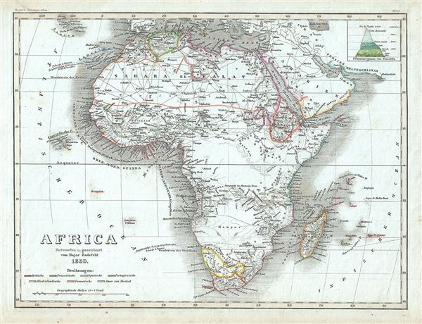
This is a fine map of Africa by Joseph Meyer dating to 1850. It covers the entire continent from the Mediterranean Sea to Cape Town, including Madagascar on the cusp of the great exploratory expeditions of the mid-19th century undertaken by Speke, Livingstone, and Stanley. Though European colonies and outposts dot the coastlines, much of the interior remains unknown, even speculative. Lake Malawi, near Mozambique, appears in embryonic form, no doubt drawn from indigenous and missionary reports, but gives some hint of the Great Rift Valley lakes soon to be discovered. An inset in the upper right quadrant details the plants on Tenerife Island, the largest of the Canary Islands.
At the time this map was made, the slave trade, thriving since the 5th century was rapidly diminishing due to decreased demand for slaves in the New World, the British outlawing of slavery in 1808, and subsequent diplomatic efforts including treaties with over 50 African rulers outlawing the practice. Many African economies adapted by shifting to the export of mineral and agricultural resources, which led to the European scramble for territory, occupying most of the continent by the end of the 19th century. Europe's colonial interests in Africa haphazardly carved up the continent into unnatural territories, often forcing historic enemies into close proximity and leading to social problems that remain to this day.
This map was issued as plate no. 95 in Meyer's Zeitung Atlas. Although all the maps in this atlas are not individually dated, the title page and maps were often updated while the imprint with the date was not, causing confusion to the exact date for some of the maps. Moreover some maps in the atlas were taped in at a later date as an update to the atlas. We have dated the maps in this collection to the best of our ability.
Cartographer
Joseph Meyer (May 9, 1796 - June 27, 1856) was a German industrialist, merchant, and publisher, active in Germany in the early to mid 19th century. He is best known for publishing the encyclopedia Meyers Conversation-Lexicon. Born in Gotha, Germany, Meyer was educated as a merchant in Frankfurt am Main. He moved to London in 1816, but returned to Germany in 1820 after his stock speculations and business adventures fell through. Once back in Germany, he began by investing in the textile trade (1820 - 24). Meyer began creating business plans concerning how to start railways soon after the first steam-hauled railway began operation in December 1835. He founded the Deutsche Eisenbahnschienen-Compangie auf Actien (German Railway Rail joint stock company) in 1845. Meyer also found great success as a publisher, utilizing the system of serial subscriptions to publications, a new idea for the time. He founded a company, Bibliographisches Institut in Gotha in 1825, which published several versions of the Bible, works of classical literature, atlases, the world in pictures on steel engravings, and an encyclopedia. He moved the Institut from Gotha to Hildburghausen in 1828. He published several atlases, including Meyer's Groẞer Hand-Atlas (1843 - 1860). In 1848, he supported the Springtime of the Peoples Revolutions that took place throughout Germany and much of Europe. When the revolutions failed in 1849, Meyer was briefly imprisoned for his support of revolutionary activities. The revolutions also began to take a toll on Meyer's business interests, and when he died, in 1856, the Bibliographisches Institut was struggling financially. His son, Herrmann Julius Meyer, took over the firm, spearheading a rapid recovery. This, and other businesses prospered under Herrmann Julius (April 4, 1826 - March 12, 1909) and when he died in 1909, he led the richest family in Saxony, with more total wealth than the King of Saxony More by this mapmaker...
Source
Meyer, J., Meyer's Zeitung Atlas, 1852.
Meyer's Zeitung Atlas, formally titled Neuster Zeitungs-Atlas Fuer Alte und Neue Erdkunde was a popular German hand-atlas published in Heidelberg by Joseph Meyer between, roughly, 1848 and 1859. The atlas is well engraved in the German style with exceptionally dense detail and minimal decoration. Meyer's Atlas, and its constituent maps, are typically very difficult to date as later editions often contain earlier maps and earlier editions later paste-in updates. That said, the atlas' frequent updates and publication run during a turbulent decade provide a noteworthy cartographic record of the period.
Condition
Very good. Minor toning and spotting at places.