This item has been sold, but you can get on the Waitlist to be notified if another example becomes available, or purchase a digital scan.
1550 Munster Map of Africa
Africa-munster-1550$950.00

Title
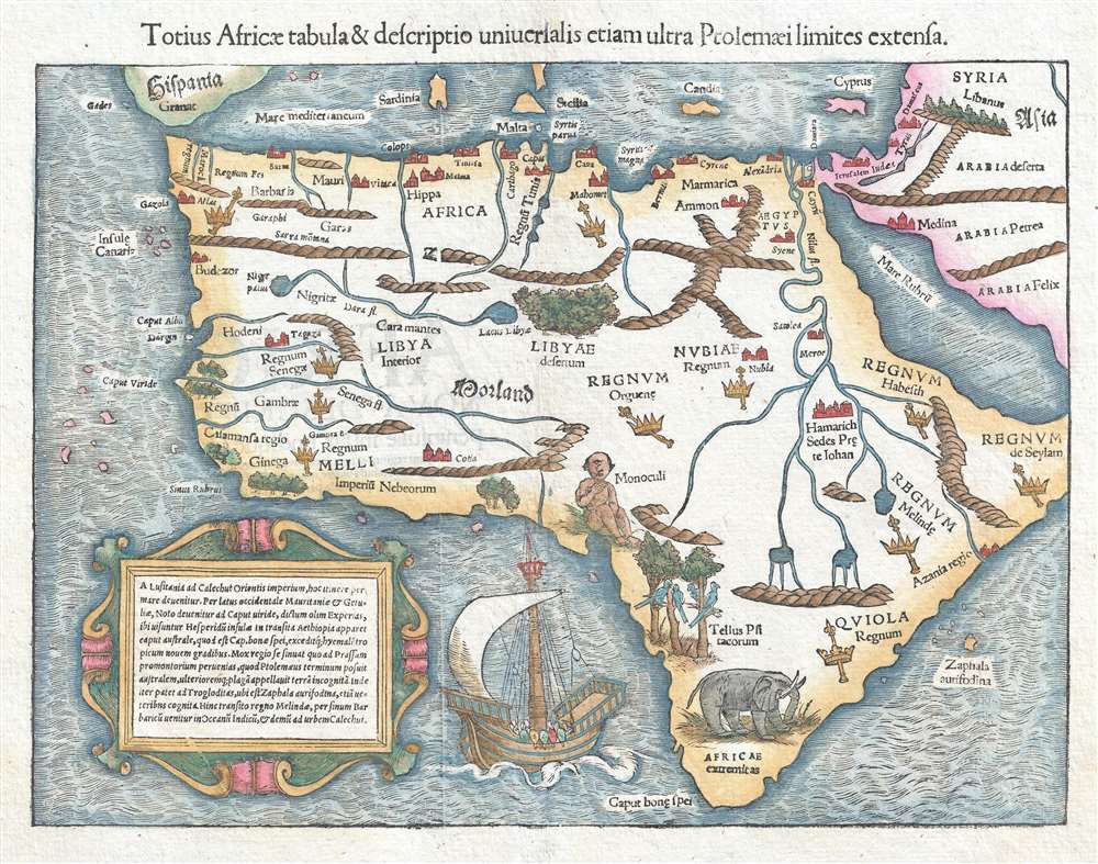
Totius Africae tabula et descriptio universalis etiam ultra Ptolemaeilimites extensa.
1550 (undated) 11.25 x 14.25 in (28.575 x 36.195 cm) 1 : 33000000
1550 (undated) 11.25 x 14.25 in (28.575 x 36.195 cm) 1 : 33000000
Description
This is a historically groundbreaking c. 1550 Sebastian Münster map of Africa. Recognized as the first map to depict the entire continent, the map stretches from the Iberian Peninsula to the Cape of Good Hope and from the Cape Verde Islands to the Red Sea and the Middle East. The first map to illustrate Africa's complete coastal outline, it is based on work by Ptolemy as well as information provided by contemporary Portuguese and Arabic sources, which is reinforced by the inclusion of a Portuguese galley and sailing instructions from the Iberian Peninsula to India on the lower left. By including this map in his works, Münster is presenting some of the most recent exploration data to the world. Bartolomeo Diaz was the first to round the Cape of Good Hope in 1488, and it would take Vasco da Gama another decade before he would successfully reach India by sea.
Münster illustrates the continent with several vignettes, including an elephant and tropical birds in southern Africa. A one-eyed-man, or cyclops, is depicted in what is today Cameroon and Nigeria, and is meant to illustrate the mythical Monoculi tribe. Numerous kingdoms are noted throughout the continent and are marked by a crown and scepter. Some of these include the Arab kingdoms of Melinde and Quiola, MMeroë, where the Nubian kings are said to be buried, and Hamarichthe capital of the kingdom of the mythical Christian king Prester John. Munster also speculates on the sources of the Nile and Niger Rivers and includes a forest in the center of the Sahara Desert.
This map was published by Sebastian Münster and published c. 1550. Editions of this map appeared in his Cosmographia universalis as well as his version of Ptolemy's Geographia.
Cartographer
Sebastian Münster (January 20, 1488 - May 26, 1552), was a German cartographer, cosmographer, Hebrew scholar and humanist. He was born at Ingelheim near Mainz, the son of Andreas Munster. He completed his studies at the Eberhard-Karls-Universität Tübingen in 1518, after which he was appointed to the University of Basel in 1527. As Professor of Hebrew, he edited the Hebrew Bible, accompanied by a Latin translation. In 1540 he published a Latin edition of Ptolemy's Geographia, which presented the ancient cartographer's 2nd century geographical data supplemented systematically with maps of the modern world. This was followed by what can be considered his principal work, the Cosmographia. First issued in 1544, this was the earliest German description of the modern world. It would become the go-to book for any literate layperson who wished to know about anywhere that was further than a day's journey from home. In preparation for his work on Cosmographia, Münster reached out to humanists around Europe and especially within the Holy Roman Empire, enlisting colleagues to provide him with up-to-date maps and views of their countries and cities, with the result that the book contains a disproportionate number of maps providing the first modern depictions of the areas they depict. Münster, as a religious man, was not producing a travel guide. Just as his work in ancient languages was intended to provide his students with as direct a connection as possible to scriptural revelation, his object in producing Cosmographia was to provide the reader with a description of all of creation: a further means of gaining revelation. The book, unsurprisingly, proved popular and was reissued in numerous editions and languages including Latin, French, Italian, and Czech. The last German edition was published in 1628, long after Münster's death of the plague in 1552. Cosmographia was one of the most successful and popular books of the 16th century, passing through 24 editions between 1544 and 1628. This success was due in part to its fascinating woodcuts (some by Hans Holbein the Younger, Urs Graf, Hans Rudolph Manuel Deutsch, and David Kandel). Münster's work was highly influential in reviving classical geography in 16th century Europe, and providing the intellectual foundations for the production of later compilations of cartographic work, such as Ortelius' Theatrum Orbis Terrarum Münster's output includes a small format 1536 map of Europe; the 1532 Grynaeus map of the world is also attributed to him. His non-geographical output includes Dictionarium trilingue in Latin, Greek, and Hebrew, and his 1537 Hebrew Gospel of Matthew. Most of Munster's work was published by his stepson, Heinrich Petri (Henricus Petrus), and his son Sebastian Henric Petri. More by this mapmaker...
Condition
Very good. Even overall toning. Text on verso.
References
OCLC 61350225.