This item has been sold, but you can get on the Waitlist to be notified if another example becomes available, or purchase a digital scan.
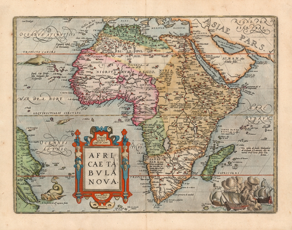
1602 Ortelius Africa Map (Spanish edition)
Africa-ortelius-1570$1,250.00

Title
Africae Tabula Nova.
1570 (dated) 14.75 x 19.75 in (37.465 x 50.165 cm) 1 : 23000000
1570 (dated) 14.75 x 19.75 in (37.465 x 50.165 cm) 1 : 23000000
Description
This is a beautiful example of Ortelius' 1570 map of Africa, here in its 1602 Spanish edition. In its first issue this was the first map of Africa to appear in an atlas, and it remained the best and most widespread general map of Africa for the remainder of the 16th century and into the 17th. It remains a most desirable map: Tooley rhapsodized:
…one of the cornerstones of any African map collection . . . a handsome, well balanced map, visually beautiful and finely engraved . . . it made a great impact upon its contemporaries and remained the standard map of Africa for the rest of the century.
Sources
Ortelius' map improved, and drew upon the Italian copperplate maps of Giocomo Gastaldi (c. 1500 - 1566) and Paolo Forlani (fl.1560 - 1571) and represented a massive improvement on the Sebastian Münster (1488 - 1552) Africa, which until 1570 represented the best depiction of Africa published north of the Alps. The map shows the results of Portuguese exploration along the coast, while much of the detail of Northern Africa was drawn from the early 16th century work of the Berber geographer/diplomat Leo Africanus (1594 -1554). Points further south rely, ultimately, on Ptolemaic sources - most notably, the delineation of the upper Nile with its sources in two massive lakes fed from the legendary Mountains of the Moon.Publication History and Census
This engraving was first printed in 1570 as one of the first maps to be included in Ortelius' seminal Theatrum Orbis Terrarum. The map remained in the Atlas for its entire run. Both Betz and van der Krogt note six state changes over the course of its print history: this example corresponds to the fifth state, characterized by the evidence of a plate crack in the map's cartouche; the verso text identifies this example as having been printed for the 1602 Spanish language edition of the Theatrum. In its many editions, this map and the Theatrum are well represented in institutional collections. This 1602 Spanish edition is catalogued in a single example, held in the Biblioteca Nacional de Espana.Cartographer
Abraham Ortelius (April 14, 1527 - June 28, 1598) also known as Ortels, was a cartographer, geographer, and cosmographer of Brabant, active in Antwerp. He was the creator of the first modern atlas, Theatrum Orbis Terrarum and is a seminal figure in the history of cartography. Along with Gerard Mercator and Gemma Frisius, he was a founder of the Netherlandish school of cartography. His connections with Spain - culminating in his 1575 appointment as Royal Cartographer to King Phillip II of Spain - gave him unmatched access to Spanish geographical knowledge during a crucial period of the Age of Discovery. Ortelius was born in 1527 in Antwerp. In 1547 he entered the Antwerp Guild of Saint Luke as an illuminator of maps. He began trading in books, prints, and maps, traveling regularly to the Frankfurt book and print fair, where in 1554 he met Mercator. He accompanied Mercator on journeys throughout France in 1560 and it was at this time, under Mercator's influence, that he appears to have chosen his career as a scientific geographer. His first published geographic work appeared in 1564, an eight-sheet cordiform world map. A handful of other maps preceded the 1570 publication of the first edition of the Theatrum Orbis Terrarum, which would prove to be his life work. Appearing with but 53 maps in its first edition, Ortelius' work expanded with new maps added regularly. By 1592, it had 134 maps. Many of Ortelius' maps remained the standard for nearly a century. He traveled extensively, but his genius was as a compiler, locating the best informed maps on which to base his own. His contacts throughout Europe and extending even (via the Portuguese) to the Far East were formidable. Moreover, many of his maps were based on his own scholarship, particularly his historical works. His theories of geography were particularly ahead of his time with respect to the notion of continental drift, the possibility of which he mused on as early as 1596, and which would be proven correct centuries later.
In a sense his greatest achievement was his successful navigation of the religious and political violence endemic to his city throughout his adult life: The Dutch Revolt, or Eighty Years' War (1568 - 1648), fully embroiled Antwerp. Although outwardly and officially recognized as Catholic (Arias Montanus vouched for Ortelius' Catholic orthodoxy prior to his appointment as Royal Geographer), Ortelius was able to separate himself from the religious furor which characterized the war in the low countries. Ortelius showed a glimpse of himself in a letter to a friend, regarding humanist Justus Lipsius: 'I do not know whether he is an adherent of the Pope or a Calvinist, but if he has ears to hear, he will neither be one nor the other, for sins are committed on both sides'. Ortelius' own explorations of Biblical history in his maps, and the Christogram contained in his own motto, suggest him to be a religious man, but his abjuration of political religious authorities mark him as an individualist. His tombstone at St Michael's Præmonstratensian Abbey in Antwerp bears the inscription, Quietis cultor sine lite, uxore, prole. ('served quietly, without accusation, wife, and offspring.') More by this mapmaker...
Source
Ortelius, A., Theatrum Orbis Terrarum, (Amsterdam), Spanish Edition, 1602.
Abraham Ortelius' magnum opus, Theatrum Orbis Terrarum, was the world's first regularly produced atlas, which 'set the standards for later atlases . . . It was the first undertaking of its kind to reduce the best available maps to an uniform format.' (Koeman) A modestly-sized work of fifty-three maps in its first edition of May 1570, it was an immediate success: there were three further editions that year, and the work remained in print for a total of 32 editions, the last of which was 1641, well after its author's 1598 death. Ortelius added to his atlas constantly, and by 1595 the Theatrum contained 147 maps. Ortelius is renowned generally as an editor, and indeed much of the Theatrum is compiled from a variety of sources: in such cases, Ortelius was scrupulous in naming his sources. But Ortelius was also a mapmaker in his own right: many of his maps are a distillation of various sources into his own work, and there were many maps - particularly in his atlas of Biblical and ancient history Parergon - which were entirely Ortelius' work. In his role as an editor, Ortelius followed in the footsteps of Munster, whose Cosmographia was, until Ortelius, the best window on the world for the curious European reader. In terms of the artistry of his maps, Ortelius oversaw the first great flourishing of copperplate engraving in the service of cartography to occur in Northern Europe. Ortelius' work provided the model for the atlases of Mercator, Hondius, Blaeu and all their progeny in the 17th century - many of whom were to produce faithful editions of Ortelius' maps in their own productions.
Condition
Very good condition. Fine hand color. Minor unobtrusive spotting, else fine.
References
OCLC 864284534. Afriterra 1052. van den Broecke, M. Ortelius Atlas Maps #8.5. Betz, R. Mapping of Africa #12.5. Norwich, O. Maps of Africa #10.