This item has been sold, but you can get on the Waitlist to be notified if another example becomes available, or purchase a digital scan.
1892 Rand McNally Map of Africa
Africa-randmcnally-1895$50.00

Title
Map of Africa.
1892 (dated) 27 x 20 in (68.58 x 50.8 cm)
1892 (dated) 27 x 20 in (68.58 x 50.8 cm)
Description
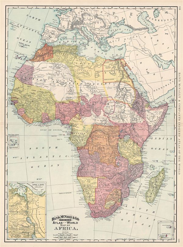
This is a beautiful example of Rand McNally and Company's 1892 map of Africa. It covers the entire continent from the Mediterranean Sea to the Cape of Good Hope, including the island of Madagascar. Parts of adjacent Arabia and europe are also included. Insets feature the Suez Canal, the Cape Verde Islands, the Cargados Carayos, and Mascarene Islands. Lake Victoria (Lake Nyanza), Lake Tanganyika and Lake Malawi (Lake Nyassa) are identified. During this period, most of Africa, except for Abyssinia and Liberia, was dominated by european colonial powers. In southern Africa, after the discovery of diamonds in 1867 and gold in 1884, colonial powers and the indigenous population struggled for control of resources. This led to the First Boer War in 1880 in which the British were defeated. The British were however victorious in the Second Boer War. After Berlin Conference of 1884 – 1885, the continent was formally divided in spheres of influence setting boundaries of colonial control. It was only after the end of the Second World War that these colonial territories would become fully independent. Color coded according to region, Rand McNally's map identifies numerous cities, tribes, and towns, as well as noting oases, rivers, deserts, mountains and various other topographical details, with relief shown by hachure. This map was issued as plate nos. 134 and 135 in the 1895 issue of Rand McNally and Company's Indexed Atlas of the World - possibly the finest atlas Rand McNally ever issued.
Cartographer
Rand, McNally and Co. (fl. 1856 - present) is an American publisher of maps, atlases and globes. The company was founded in 1856 when William H. Rand, a native of Quincy, Massachusetts, opened a print shop in Chicago. Rand hired the recent Irish immigrant Andrew McNally to assist in the shop giving him a wage of 9 USD per week. The duo landed several important contracts, including the Tribune's (later renamed the Chicago Tribune) printing operation. In 1872, Rand McNally produced its first map, a railroad guide, using a new cost effective printing technique known as wax process engraving. As Chicago developed as a railway hub, the Rand firm, now incorporated as Rand McNally, began producing a wide array of railroad maps and guides. Over time, the firm expanded into atlases, globes, educational material, and general literature. By embracing the wax engraving process, Rand McNally was able to dominate the map and atlas market, pushing more traditional American lithographic publishers like Colton, Johnson, and Mitchell out of business. Eventually Rand McNally opened an annex office in New York City headed by Caleb S. Hammond, whose name is today synonymous with maps and atlases, and who later started his own map company, C. S. Hammond & Co. Both firms remain in business. More by this mapmaker...
Source
Rand McNally & Co., Foreign Countries. Rand, McNally & Co's Indexed Atlas of the World (Complete in Two Volumes)…, (Chicago) 1895.
Condition
Very good. Original centerfold. Text on verso.
References
Rumsey 3565.035 (1897 edition). Philip (atlases) 1026 (1898 edition).