
This item below is out of stock, but another example (left) is available. To view the available item, click "Details."
Details
1817 Thomson Map of North Africa and South Africa
1817 (undated) $350.00
1815 Thomson Map of Africa
Africa-thomson-1814$200.00

Title
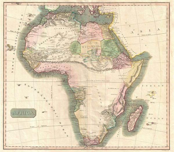
Africa.
1814 (undated) 18.5 x 20.5 in (46.99 x 52.07 cm)
1814 (undated) 18.5 x 20.5 in (46.99 x 52.07 cm)
Description
This hand colored map is a steel plate engraving, dating to 1813 by the important English mapmaker John Thomson. It is an early and historically important representation of the continent of Africa. Much of the continent is simply labeled 'unknown parts,' but some regions are surprisingly detailed. Caravan routes, temples, and even the distances between Oases are noted. Across the center of the continent Thomson details the mythical mountain range known as the 'Mountains of the Moon.' The Mountains of the Moon were first postulated by Ptolemy to be the source of the Nile in the 2nd Century AD. This mysterious range remained on maps until the mid 19th century explorations of Burton, Speke, and Livingstone. Today it is generally agreed that references to the Mountains of the Moon refer to the Ruwenzori Range of Kenya & Uganda. This mountain range remains one of the most remote and exotic places on Earth, and is the home of a diversity of bizarre plant and animal life. Even so, it is not, as postulated, the source of the Nile which lies just to the south in Lake Victoria. Neither Lake Victoria nor Lake Tanganyika appear on this map. Thomson maps are known for their stunning color, awe inspiring size, and magnificent detail. Thomson's work, including this map, represents some of the finest cartographic art of the 19th century.
Cartographer
John Thomson (1777 - c. 1841) was a Scottish cartographer, publisher, and bookbinder active in Edinburgh during the early part of the 19th century. Thomson apprenticed under Edinburgh bookbinder Robert Alison. After his apprenticeship, he briefly went into business with Abraham Thomson. Later, the two parted ways, John Thomson segueing into maps and Abraham Thomson taking over the bookbinding portion of the business. Thomson is generally one of the leading publishers in the Edinburgh school of cartography, which flourished from roughly 1800 to 1830. Thomson and his contemporaries (Pinkerton and Cary) redefined European cartography by abandoning typical 18th-century decorative elements such as elaborate title cartouches and fantastic beasts in favor of detail and accuracy. Thomson's principle works include Thomson's New General Atlas, published from 1814 to 1821, the New Classical and Historical Atlas of 1829, and his 1830 Atlas of Scotland. The Atlas of Scotland, a work of groundbreaking detail and dedication, would eventually bankrupt the Thomson firm in 1830, at which time their plates were sequestered by the court. The firm partially recovered in the subsequent year, allowing Thomson to reclaim his printing plates in 1831, but filed again for bankruptcy in 1835, at which time most of his printing plates were sold to A. K. Johnston and Company. There is some suggestion that he continued to work as a bookbinder until 1841. Today, Thomson maps are becoming increasingly rare as they are highly admired for their impressive size, vivid hand coloration, and superb detail. More by this mapmaker...
Source
Thomson, J. A New General Atlas, (Edinburgh) 1814.
Condition
Very good condition. Original centerfold. Some offsetting. Blank on verso. Original platemark visible.
References
Rumsey 1007.052. Phillips (Atlases) 731. Newberry Library: Ayer 135 T4 1817.