This item has been sold, but you can get on the Waitlist to be notified if another example becomes available, or purchase a digital scan.
1794 Boulton and Anville Wall Map of Africa (most important 18th cntry map of Africa)
Africa2-boulton-1794$1,750.00

Title
Africa, with all its States, Kingdoms, Republics, Regions, Islands, & cca. Improved and Inlarged form D’Anville’s Map to which has been added A Particular Chart of the Gold Coast wherein are Distinguished all the European Forts, and Factories by S. Boulton and also A Summary Description relative to the Trade adn Natural Produce, Manners and Customs of the African Continent and Islands.
1794 (dated) 41 x 49 in (104.14 x 124.46 cm)
1794 (dated) 41 x 49 in (104.14 x 124.46 cm)
Description
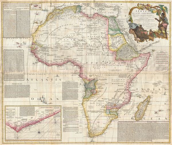
This is probably the most important map of Africa produced in the 18th century. Largely based upon the earlier D'Anville map, this map has been enlarged and expanded by Samuel Boulton. Depicts the continent in full with insets of the Gold Coast (or Ivory Coast, or Guinea). This map is unique in that it is a serious attempt to compile all of the accurate scientific knowledge of the African continent available at the time. In contrast to many other Africa maps of the period there almost no attempt to fill the 'unknown' regions of the interior with fictitious beasts, kingdoms, and geological features. Boulton himself advertises 'The inland parts of Africa being but very little known and the names of the regions and countries which fill that vast tract of land being for the greatest part placed by conjecture it may be judged how absurd are the divisions traced in some maps and why they are not followed in this.' Despite this, this map actually does provide a wealth of information both in the form of a gazetteer printed in framed text boxes here and there on the map, as well as political and geographical features.
This map bears up to almost endless perusal and volumes could be composed on its content. The cartographer attempts to depict both known and unknown parts of the continent with actual data reported by both contemporary and ancient travelers. In most cases it is extremely difficult to identify specific sources as much of the data is vague and uncertain. Boulton for example notes a community of Jews near what would today be Mali. Though a very small community of Jewish traders did live in Mali in the 15th century, most had been killed or converted to Islam by the 16th century. No doubt Boulton's sources here were extremely archaic. Boulton also relies heavily on the geography of Claudius Ptolemy, noting this source in numerous notations which range from commentary on local peoples to the courses of important river systems. Clearly much of the map is focused on commerce and where information is available, Boulton makes notes on local commercial products and mineral wealth. There are also copious notations on caravan routes, especially those routes which were known to offer caravan transverse of the Sahara.
Generally following Ptolemy, Boulton includes a number of mysterious river systems which seem to appear out of nowhere and run to nowhere. With regard to the White Nile, which he presumes correctly to be greater than the Blue Nile, he follows the ancient 'two lakes at the base of the Mountains of the Moon' theory.
In the southern half of Africa there is considerably less information on the interior save for those lands mapped by the Portuguese along the Congo and Zambezi Rivers. The regions around the Zambezi, called Monomotapa, are particularly interesting as many considered this area to be the Biblical land of Ophir, where one could discover the mines of King Solomon. Just north of Monomotapa we find an embryonic representation of Lake Malawi, here called Maravi. In South Africa the Dutch Company is strongly established and the region is well mapped well into the interior.
Prepared by Samuel Boulton and published by Laurie & Whittle in Kitchin's 1794 General Atlas.
CartographerS
Solomon Boulton (fl. c. 1750-1775), sometimes written as 'Bolton,' was an English cartographer active in the middle part of the 18th century. Bolton's most notable works are the adaptions of Jean Baptiste Bourguignon d'Anville (1697 - 1782) maps published in conjunction with Malachy Postlethwayte's Dictionary of Commerce. These were later reprinted and embellished by Sayer and Bennett, and again by Laurie and Whittle. More by this mapmaker...
Laurie and Whittle (fl. 1794 - 1858) were London, England, based map and atlas publishers active in the late 18th and early 19th century. Generally considered to be the successors to the Robert Sayer firm, Laurie and Whittle was founded by Robert Laurie (c. 1755 - 1836) and James Whittle (1757-1818). Robert Laurie was a skilled mezzotint engraver and is known to have worked with Robert Sayer on numerous projects. James Whittle was a well-known London socialite and print seller whose Fleet Street shop was a popular haunt for intellectual luminaries. The partnership began taking over the general management of Sayer's firm around 1787; however, they did not alter the Sayer imprint until after Sayer's death in 1794. Apparently Laurie did most of the work in managing the firm and hence his name appeared first in the "Laurie and Whittle" imprint. Together Laurie and Whittle published numerous maps and atlases, often bringing in other important cartographers of the day, including Kitchin, Faden, Jefferys and others to update and modify their existing Sayer plates. Robert Laurie retired in 1812, leaving the day to day management of the firm to his son, Richard Holmes Laurie (1777 - 1858). Under R. H. Laurie and James Whittle, the firm renamed itself "Whittle and Laurie". Whittle himself died six years later in 1818, and thereafter the firm continued under the imprint of "R. H. Laurie". After R. H. Laurie's death the publishing house and its printing stock came under control of Alexander George Findlay, who had long been associated with Laurie and Whittle. Since, Laurie and Whittle has passed through numerous permeations, with part of the firm still extant as an English publisher of maritime or nautical charts, 'Imray, Laurie, Norie and Wilson Ltd.' The firm remains the oldest surviving chart publisher in Europe. Learn More...
Thomas Kitchin (August 4, 1718 – June 23, 1784) was a London based engraver, cartographer, and publisher. He was born in London to a hat-dyer of the same name. At 14, Kitchin apprenticed under Emanuel Bowen, under whom he mastered the art of engraving. He married Bowen daughter, Sarah Bowen, and later inherited much of his preceptor's prosperous business. Their son, Thomas Bowen Kitchin, also an engraver joined the family business, which thereafter published in Thomas Kitchin and Son. From 1858 or so Kitchin was the engraver to the Duke of York, and from about 1773 acquired the title, 'Royal Hydrographer to King George III.' He is responsible for numerous maps published in the The Star, Gentleman's Magazine, and London Magazine, as well as partnering with, at various times, with Thomas Jefferys, Emmanuel Bowen, Thomas Hinton, Issac Tayor, Andrew Dury, John Rocque, Louis de la Rochette, and Alexander Hogg, among others. Kitchin passed his business on to his son, Thomas Bowen Kitchin, who continued to republish many of his maps well after his death. Kitchin's apprentices included George Rollos, Bryant Lodge, Thomas Bowen Kitchin, Samuel Turner Sparrow, John Page, and Francis Vivares. Learn More...
Source
Kitchin, Thomas, Kitchin's General Atlas, describing the Whole Universe: being a complete collection of the most approved maps extant; corrected with the greatest care, and augmented from the last edition of D'Anville and Robert with many improvements by other eminent geographers, engraved on Sixty-Two plates, comprising Thirty Seven maps., Laurie & Whittle, London, 1797.
Condition
Very good condition. Original centerfold. Blank on verso. Original platemark visible. Wide clean margins. Light offsetting. Four sheets joined.
References
Rumsey, 0411.035, 0411.034, 0411.036. Tooley R. V., Maps of Africa (Map collectors circle no. 47), p. 4. Phillips (Atlases) 4300.