1630 / 1640 Blaeu Map of Africa: Scarce Second State, Superb Original Color
Africae-blaeu-1630$5,000.00

Title
Africae nova descriptio. Auct: Guiljelmo Blaeuw.
1630 (undated) 16.25 x 22 in (41.275 x 55.88 cm) 1 : 25000000
1630 (undated) 16.25 x 22 in (41.275 x 55.88 cm) 1 : 25000000
Description
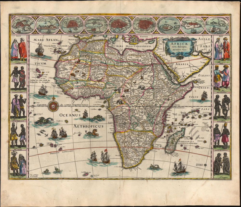
This is a superb, original-color, second-state example of Willem Blaeu's 1630 carte à figure atlas map of Africa, in its 1640 Latin-text atlas edition. It is one of the most desirable maps of the Dutch Golden Age. Norwich hailed it rightly as 'one of the most decorative and popular of all the early maps of Africa.'
Blaeu's map is a reduced version of his 1608 wall map, the standard for mapping Africa until the late 17th century. Blaeu's atlas map here, first engraved in 1617, is prized for its clarity and sharpness, presenting copious detail (and its many decorative features) without sacrificing legibility. The coastline, in particular, is rich in toponomy, and the overall shape of the continent is remarkably accurate. Points within the continent, nonetheless, reveal the European ignorance of Africa's interior that would persist until well into the 19th century. The Nile, for example, is illustrated with its sources in the lakes of Zaire and Zaflan, an assumption inherited from the 2nd-century Alexandrian geographer Claudius Ptolemy. The equally fictitious Lake Sachaf, derived from Laurent Fries' 1522 geography, appears in southern Africa, feeding the Zambere River, flowing to the Rio de Spirito Santo. The Cuama River is shown north of the Rio de Spirito Santo, but unlike earlier maps - including Blaeu's own wall map - the Cuama is given its own source. The Niger River is shown running in the wrong direction, emptying into the Senegal River after having flowed from an imagined Lake Niger in the general vicinity of what is now the Central African Republic. (A detailed mapping of the Niger was complete until the 1890s.)
Cartes à figures were deluxe productions and seldom produced for narrow, regional maps save in scarce separate issues, and not all mapmakers included them in regular atlases. Willem Blaeu's world and continental maps are considered classics of the form.
A Closer Look
The seas are filled with ships and sea monsters, while the land teems with elephants, ostriches, lions, and other beasts. The borders depict the greatest contemporaneous African cities and interpretations of indigenous dress. Although separated from Europe only by the Mediterranean, Europeans were as ignorant of Africa as they were of the remotest portions of Asia or the Americas. Maps such as this one provided a glimpse into what amounted to a different world.Blaeu's map is a reduced version of his 1608 wall map, the standard for mapping Africa until the late 17th century. Blaeu's atlas map here, first engraved in 1617, is prized for its clarity and sharpness, presenting copious detail (and its many decorative features) without sacrificing legibility. The coastline, in particular, is rich in toponomy, and the overall shape of the continent is remarkably accurate. Points within the continent, nonetheless, reveal the European ignorance of Africa's interior that would persist until well into the 19th century. The Nile, for example, is illustrated with its sources in the lakes of Zaire and Zaflan, an assumption inherited from the 2nd-century Alexandrian geographer Claudius Ptolemy. The equally fictitious Lake Sachaf, derived from Laurent Fries' 1522 geography, appears in southern Africa, feeding the Zambere River, flowing to the Rio de Spirito Santo. The Cuama River is shown north of the Rio de Spirito Santo, but unlike earlier maps - including Blaeu's own wall map - the Cuama is given its own source. The Niger River is shown running in the wrong direction, emptying into the Senegal River after having flowed from an imagined Lake Niger in the general vicinity of what is now the Central African Republic. (A detailed mapping of the Niger was complete until the 1890s.)
The Cities
Along the top border of the map are nine medallions containing views of African cities: Tanger (Tangiers) in northwestern Morocco; Ceuta in Northern Africa (now Spanish, then Portuguese); Alger (Algiers); Tunis; Alexandria; and Cairo. All six cities were, from classical times, within the European orbit. The remaining three cities represented - Mozambique, St. Georges de la Mina, and Canaria (Tenerife, in the Canary Islands) reflect the growing reach of Europe during the age of discovery. Each was a key port for the circumnavigation of Africa, with Portuguese forts established by the time this map was published. Of these, the St. Georges de la Mina was notorious as a staging area in the transatlantic slave trade. Blaeu's source for these views was the Braun and Hogenberg Civitates Orbis Terrarum, the first printed 'town book'.Cartes à Figures
During the Dutch Golden Age in the first half of the 17th century, maps' decorative elements reached a height that would be alluded to but seldom matched in later periods. 'Cartes à Figures,' that is to say maps with figural decorative borders, were at the pinnacle of Dutch decorative cartography. These decorations were not without purpose. Atlas maps of the day were not meant to guide travel but rather were intended to inform the literate layperson what the rest of the world was like. The upper decorative border of this map, with its city plans and views, communicates how the denizens of Africa look and dress. Blaeu's Africa features Moroccans, Egyptians, Senegalese, Abyssinians, Guinean merchants, Mozambicans, a couple from Cape Lopez in Gabon, a royal couple from Madagascar, a Congolese soldier and his wife, and a fearsome portrayal of the denizens of the Cape of Good Hope.Cartes à figures were deluxe productions and seldom produced for narrow, regional maps save in scarce separate issues, and not all mapmakers included them in regular atlases. Willem Blaeu's world and continental maps are considered classics of the form.
Publication History and Census
This map was first engraved in 1617 and offered as a separate issue. The map was included in Blaeu's atlases from 1630 to 1672. No printings of the map later than this are known, indicating that the copperplate was among those destroyed in the great fire that finished the company. The second state of this map (of which this is an example) exists in separately issued examples and appeared in the Blaeu atlas beginning with the 1630 Appendix. The plate remained unchanged until it was reworked in 1647. The verso typography of this example conforms to the 1640 Latin edition of the atlas. The map and its atlas are well represented in institutional collections, but examples with old color of this quality and condition have grown scarce on the market.Cartographer
Willem Janszoon Blaeu (1571 - October 18, 1638), also known as Guillaume Blaeu and Guiljelmus Janssonius Caesius, was a Dutch cartographer, globemaker, and astronomer active in Amsterdam during the late 16th and early 17th centuries. Blaeu was born 'Willem Janszoon' in Alkmaar, North Holland to a prosperous herring packing and trading family of Dutch Reformist faith. As a young man, he was sent to Amsterdam to apprentice in the family business, but he found the herring trade dull and instead worked for his cousin 'Hooft' as a carpenter and clerk. In 1595, he traveled to the small Swedish island of Hven to study astronomy under the Danish Enlightenment polymath Tycho Brahe. For six months he studied astronomy, cartography, instrument making, globe making, and geodesy. He returned to Alkmaar in 1596 to marry and for the birth of his first son, Johannes (Joan) Blaeu (1596 – 1673). Shortly thereafter, in 1598 or 1599, he relocated his family to Amsterdam where he founded the a firm as globe and instrument makers. Many of his earliest imprints, from roughly form 1599 - 1633, bear the imprint 'Guiljelmus Janssonius Caesius' or simply 'G: Jansonius'. In 1613, Johannes Janssonius, also a mapmaker, married Elizabeth Hondius, the daughter of Willem's primary competitor Jodocus Hondius the Elder, and moved to the same neighborhood. This led to considerable confusion and may have spurred Willam Janszoon to adopt the 'Blaeu' patronym. All maps after 1633 bear the Guiljelmus Blaeu imprint. Around this time, he also began issuing separate issue nautical charts and wall maps – which as we see from Vermeer's paintings were popular with Dutch merchants as decorative items – and invented the Dutch Printing Press. As a non-Calvinist Blaeu was a persona non grata to the ruling elite and so he partnered with Hessel Gerritsz to develop his business. In 1619, Blaeu arranged for Gerritsz to be appointed official cartographer to the VOC, an extremely lucrative position that that, in the slightly more liberal environment of the 1630s, he managed to see passed to his eldest son, Johannes. In 1633, he was also appointed official cartographer of the Dutch Republic. Blaeu's most significant work is his 1635 publication of the Theatrum orbis terrarum, sive, Atlas Novus, one of the greatest atlases of all time. He died three years later, in 1638, passing the Blaeu firm on to his two sons, Cornelius (1616 - 1648) and Johannes Blaeu (September 23, 1596 - December 21, 1673). Under his sons, the firm continued to prosper until the 1672 Great Fire of Amsterdam destroyed their offices and most of their printing plates. Willem's most enduring legacy was most likely the VOC contract, which ultimately passed to Johannes' son, Johannes II, who held the position until 1617. As a hobbyist astronomer, Blaeu discovered the star now known as P. Cygni. More by this mapmaker...
Source
Blaeu, W., Theatrum Orbis Terrarum, (Amsterdam: Blaeu) 1640.
The classic Dutch atlas, whose publication ushered in the Dutch golden age of cartography. Willem Jansz Blaeu had been, since 1604, producing engraved maps for sale; these were separate issues (and all consequently extremely rare) until the publishing of Blaeu's Appendix in 1630 and 1631, which also included a number of maps purchased from the widow of Jodocus Hondius, (for example his famous iteration of John Smith's map of Virginia.) In 1634, he announced his intention to produce a new world atlas in two volumes, entitled Theatrum Orbis Terrarum, sive Atlas Novus (Théâtre du Monde ou Nouvel Atlas) (in an effort to invoke the successful work of the same title produced by Ortelius the previous century, while reinforcing the notion of it being a new work.) This work was published first in German in 1634, followed by Latin, Dutch and French editions in 1635. Blaeu's maps have always been noted for the quality of their paper, engraving and fine coloring, and this was the intent from the very start. The 1634 announcement of the upcoming work described it: 'All editions on very fine paper, completely renewed with newly engraved copperplates and new, comprehensive descriptions.' (van der Krogt, p,43) Many of the most beautiful and desirable maps available to the modern collector were printed and bound in Blaeu's atlases. Willem's son, Joan, would go on to add further volumes to the Atlas Novus, concurrently printing new editions of the first two volumes with additional maps, in effect making these new editions an entirely new book. Under Joan there would be nine Latin editions, twelve French, at least seven Dutch, and two German. This exceedingly successful work would be the mainstay of the Blaeu firm until 1661, at which point the work was supplanted by Joan Blaeu's masterwork Atlas Maior in 1662.
Condition
Excellent. Few marginal spots; else fine with superb original color, heightened with gold.
References
Rumsey 12202.000 (1630 Appendix issue). OCLC 556199253 (Dutch 1650). Betz The Mapping of Africa, 57.2. Van der Krogt, P. C. J., Koeman's Atlantes Neerlandici, (3 Vols), 8600:2. Norwich, O., Norwich's Maps of Africa: An illustrated and Annotated Carto-bibliography, #32.