This item has been sold, but you can get on the Waitlist to be notified if another example becomes available, or purchase a digital scan.
1770 Bonne Map of Mozambique, Madagascar, Réunion, and Mauritius
AfricaEast2-bonne-1770$175.00

Title
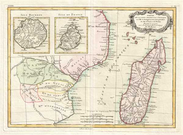
Partie de la Cote Orientale D'Afrique avec L'Isle de Madagascar et les Cartes particulieres des Isles de France et de Bourbon.
1770 (undated) 11.5 x 16 in (29.21 x 40.64 cm) 1 : 7000000
1770 (undated) 11.5 x 16 in (29.21 x 40.64 cm) 1 : 7000000
Description
This is a 1770 Rigobert Bonne map of southeastern Africa and Madagascar. The map depicts the East African coastline of modern-day Mozambique and the island of Madagascar. Inset maps of the islands of Réunion (Isle Bourbon) and Mauritius (Isle de France).
This region of Africa held a particular fascination for Europeans since it was first explored by the Portuguese in the 16th century. At the time, this area was a vast empire called Mutapa or Monomotapa, which maintained an active trading network with faraway partners in India and Asia. As the Portuguese presence in the area increased in the 17th century, the Europeans began to note that Monomatapa was particularly rich in gold. They were also impressed with the numerous well-crafted stone structures, including the mysterious nearby ruins of Great Zimbabwe. This combination led many Europeans to believe that King Solomon's mines must be hidden in this region. This is reinforced by notations on this map labeling the 'Mts. Fuca riches en Or' (Fuca Mountains rich in gold) in the western parts of Monomotapa. Monomotapa did in fact have rich gold mines in the 16th and 17th centuries, but most have these had been exhausted by the 1700s.
Numerous rivers are illustrated and labeled both along the African, on Madagascar, and on both Réunion and Mauritius. Points along the coastlines of all four locations bear labels as well, such as points, smaller islands, or bays. Short notations are included on continental Africa discussing names of kings or characteristics of certain regions. Several towns are labeled. A decorative title cartouche appears in the upper right corner.
Drawn by Rigobert Bonne in 1770 for issue Jean Lattre's 1776 issue of the Atlas Moderne.
CartographerS
Rigobert Bonne (October 6, 1727 - September 2, 1794) was one of the most important French cartographers of the late 18th century. Bonne was born in Ardennes à Raucourt, France. He taught himself mathematics and by eighteen was a working engineer. During the War of the Austrian Succession (1740 - 1748) he served as a military engineer at Berg-op-Zoom. It the subsequent years Bonne became one of the most respected masters of mathematics, physics, and geography in Paris. In 1773, Bonne succeeded Jacques-Nicolas Bellin as Royal Cartographer to France in the office of the Hydrographer at the Depôt de la Marine. Working in his official capacity, Bonne compiled some of the most detailed and accurate maps of the period - most on an equal-area projection known erroneously as the 'Bonne Projection.' Bonne's work represents an important step in the evolution of the cartographic ideology away from the decorative work of the 17th and early 18th century towards a more scientific and practical aesthetic. While mostly focusing on coastal regions, the work of Bonne is highly regarded for its detail, historical importance, and overall aesthetic appeal. Bonne died of edema in 1794, but his son Charles-Marie Rigobert Bonne continued to publish his work well after his death. More by this mapmaker...
Jean Lattré (170x - 178x) was a Paris based bookseller, engraver, globe maker, calligrapher, and map publisher active in the mid to late 18th century. Lattré published a large corpus of maps, globes, and atlases in conjunction with a number of other important French cartographic figures, including Janvier, Zannoni, Bonne and Delamarche. He is also known to have worked with other European cartographers such as William Faden of London and the Italian cartographer Santini. Map piracy and copyright violations were common in 18th century France. Paris court records indicate that Lattré brought charges against several other period map publishers, including fellow Frenchman Desnos and the Italian map engraver Zannoni, both of whom he accused of copying his work. Lattré likes trained his wife Madame Lattré (né Vérard), as an engraver, as a late 18th century trade card promotes the world of 'Lattré et son Epouse.' Lattré's offices and bookshop were located at 20 rue St. Jaques, Paris, France. Later in life he relocated to Bordeaux. Learn More...
Source
Lattre, Jean, Atlas Moderne ou Collection de Cartes sur Toutes les Parties du Globe Terrestre, c. 1775.
Condition
Very good. Original platemark visible. Blank on verso.
References
Rumsey 2612.068. National Library of Australia, MAP RM 3126. Phillips (Atlases) 664. National Maritime Museum, 215. OCLC 644989125.