This item has been sold, but you can get on the Waitlist to be notified if another example becomes available, or purchase a digital scan.
1797 Laurie and Whittle Nautical Map of Mozambique and Madagascar (the Inner Passage)
AfricaMadagascar-laruiewhittle-1797$625.00

Title
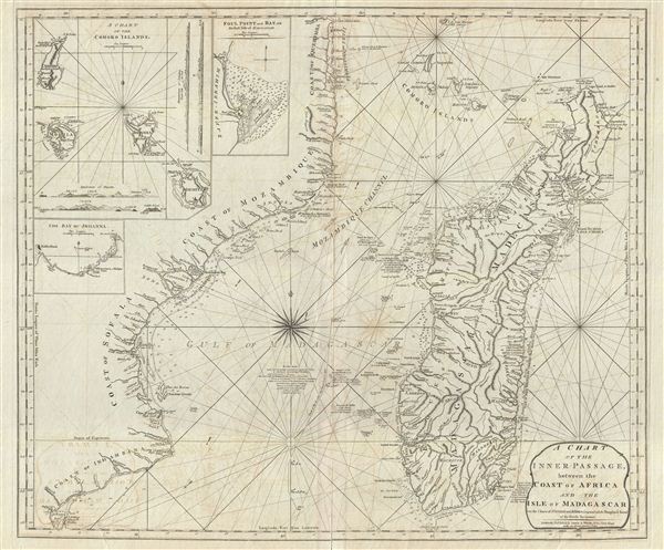
A Chart of the Inner Passage between the Coast of Africa and th Isle of Madagascar.
1797 (dated) 24.5 x 28.5 in (62.23 x 72.39 cm) 1 : 3076000
1797 (dated) 24.5 x 28.5 in (62.23 x 72.39 cm) 1 : 3076000
Description
An extremely scarce 1797 nautical chart or maritime map of the inner passage between Madagascar and southeast Africa. The chart includes the coast of modern day Mozambique from Cape Delgado and the Comoros Islands southwards as far as modern day Maputo (Da'Lagoa Bay). The island of Madagascar is rendered in full with rich inland detail throughout. Insets in the upper left quadrant illustrate the Comoros Islands, the Bay of Johanna, and Foul Point and Bay (just south of Ile Sainte-Marie). Numerous depth soundings throughout. Rhumb lines radiate from various compass points.
The Mozambique - Madagascar region was one of the earliest parts of sub-Saharan Africa to be settled and explored by Europeans. It was first explored by the Portuguese on their way around Africa to India. Rumors of gold wealth associated with the Biblical treasures of King Solomon (Ophir) on the interior led to the development of Portuguese entrepôts in Sofala and along the Zambezi River. The Kings of Portugal had visions of a gold rich colony to compete with the Spanish discoveries in the Americas; however, most of gold mines of Zimbabwe had been exhausted hundreds of year before. Instead the region developed as a base for the trip around Africa to the Indies.
In the 17th century, Madagascar, with its forbidding reef-ridden coastline and amicable population became a pirate haven, hosting such infamous buccaneers and John Avery, Henry Every, Thomas Tew, and Captain Kidd. By the time this map was drawn the passage in and around Madagascar had become particularly dangers. Pirates had established themselves on Nosy Boraha (here Nossi Ibraham or Isle St. Marys) or as it is more commonly known Ile Sainte-Marie, an excellent and sheltered port on the northeastern side of the Madagascar. Near here, legends tell of a utopian pirate republic, called Libertatia or Libertalia, established in the 17th century. When Captain William Kidd visited in 1697 to undertake repairs to his ship, he is said to have lost half his crew to the delights of Libertatia. Nonethelss by 1825 piracy in the region had diminished significantly under continual pressure from European merchant navies.
Cartographically Laurie and Whittle credit earlier mappings by the French chartmakers Jean-Baptiste d'Après de Mannevillette and Jean Baptiste Bourguignon d'Anville as well as updates and revisions drawn from the maps and journals of various unnamed British navigators. This map was published by Laurie and Whittle from their offices at 53 Fleet Street, London, on January 1, 1797. The map was issued independently as well as offered in their 1797 East-India Pilot, or Oriental Navigator.
Cartographer
Laurie and Whittle (fl. 1794 - 1858) were London, England, based map and atlas publishers active in the late 18th and early 19th century. Generally considered to be the successors to the Robert Sayer firm, Laurie and Whittle was founded by Robert Laurie (c. 1755 - 1836) and James Whittle (1757-1818). Robert Laurie was a skilled mezzotint engraver and is known to have worked with Robert Sayer on numerous projects. James Whittle was a well-known London socialite and print seller whose Fleet Street shop was a popular haunt for intellectual luminaries. The partnership began taking over the general management of Sayer's firm around 1787; however, they did not alter the Sayer imprint until after Sayer's death in 1794. Apparently Laurie did most of the work in managing the firm and hence his name appeared first in the "Laurie and Whittle" imprint. Together Laurie and Whittle published numerous maps and atlases, often bringing in other important cartographers of the day, including Kitchin, Faden, Jefferys and others to update and modify their existing Sayer plates. Robert Laurie retired in 1812, leaving the day to day management of the firm to his son, Richard Holmes Laurie (1777 - 1858). Under R. H. Laurie and James Whittle, the firm renamed itself "Whittle and Laurie". Whittle himself died six years later in 1818, and thereafter the firm continued under the imprint of "R. H. Laurie". After R. H. Laurie's death the publishing house and its printing stock came under control of Alexander George Findlay, who had long been associated with Laurie and Whittle. Since, Laurie and Whittle has passed through numerous permeations, with part of the firm still extant as an English publisher of maritime or nautical charts, 'Imray, Laurie, Norie and Wilson Ltd.' The firm remains the oldest surviving chart publisher in Europe. More by this mapmaker...
Source
Laurie, R., and Whittle, J., The East-India Pilot, or Oriental Navigator, on One Hundred and Eighteen Plates: Containing a Complete Collection of Charts and Plans, &c., &c. for the Navigation not only of the Indian and China Seas, but of those also between England and the Cape of Good-Hope; Improved and Chiefly Composed from the Last Work of M. D'Apres de Mannevillette; with Considerable Additions, from Private Manuscripts of the Dutch, and from Draughts and Actual Surveys Communicated By Officers of the East-India Company A New Edition, Containing One Hundred and Five Charts. (London: Laurie and Whittle) 1797.
Condition
Very good. Verso wear and reinforcement. Some transference. Very wide margins. Else clean.
References
Afriterra, no. 443.