This item has been sold, but you can get on the Waitlist to be notified if another example becomes available.
1942 Chapin Map of North Africa During World War II
AfricanBattlegrounds-chapin-1942$200.00


Title
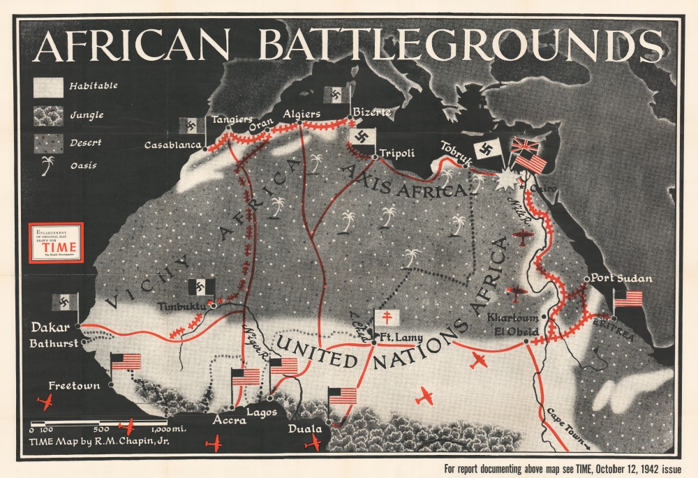
African Battlegrounds.
1942 (dated) 32 x 46.5 in (81.28 x 118.11 cm) 1 : 6850000
1942 (dated) 32 x 46.5 in (81.28 x 118.11 cm) 1 : 6850000
Description
This is a separately issued large-format 1942 Robert M. Chapin, Jr. map of North Africa. Focusing on the northern half of the continent, red lines connect major population centers and flags identify European occupation. In an intriguing detail, Vichy French-occupied cities are marked by flags bearing swastikas, leaving little doubt as to how the editors of TIME viewed Pétain's regime. Rail lines between Casablanca, Oran, Bizerte, and Timbuktu are illustrated, as are lines between Cairo and Eritrea. Airplane silhouettes reference the air resupply route between the United States and Cairo via West Africa.
World War II in North Africa
This map was published three weeks before Operation Torch, the Allied invasion of Morocco and Algeria. An important detail to remember is that it was published before the Torch landings. This means that Chapin did not know where, or even if, a second front would be opened in Africa, despite signs pointed toward the possibility. On this map, the fighting between General Sir Bernard Law Montgomery and his 8th Army and General Erwin Rommel's Afrika Korps in Egypt is highlighted, but the future events remained the subject of speculation. After the Torch landings, the American, British, and French forces that participated in the landings marched across Morocco and Algeria toward Tunisia. Unfortunately for the Allies, delays in the drive across Algeria allowed the Axis forces in Tunisia to reinforce and more than triple their overall strength. The cities of Tunis and Bizerte in northern Tunisia were fortified and the Allies faced an unknown foe in the form of five brand new Pz. VI (Tiger) tanks. Per the Encyclopedia Britannica,The Allies had lost the race to Tunis, but that tactical failure would yield an enormous strategic victory; Hitler and Mussolini were thus induced to pour significant resources into Tunisia at a time when those assets were desperately needed elsewhere.The dogged fighting in North Africa dragged on for another six months, but Axis forces finally surrendered on May 13, 1943.
Publication History and Census
This map is an enlargement of a map created by Robert M. Chapin, Jr. and originally published in the October 12, 1942 edition of TIME Magazine. An example is cataloged in OCLC and is part of the institutional collection at Franklin and Marshall College.Cartographer
Robert M. Chapin Jr. (fl. 1933 - 1970) was a prominent architect, cartographer and illustrator active during World War II and the Cold War. Chapin graduated from the University of Pennsylvania in 1933 with a degree in architecture. Since this was the height of the Great Depression, and architects in low demand, he instead took work as a staff cartographer at Newsweek. Catching the attention of Manfred Gottfried of Time, Chapin was offered an accepted a position at the head of Time's cartography department. He remained with Time for some 33 years, from 1937 to 1970, often drawn 2 - 3 new thematic maps weekly. With an architect's gift visualizing information, Chapin became a skilled informational cartographer, heading the cartography department at Time Magazine. Chapin, like Fortune Magazine chief cartographer, Richard Edes Harrison, Chapin was at the forefront of infographic propaganda cartography, a genre that matured during the World War II Era and remains popular today. Working for Time Magazine, Chapin developed a signature style for his long run of 'War Maps.' Chapin was known for his maverick airbrush technique which lead to strong color splashes and intense shading. He also incorporated celluloid stencils to illustrate bomb explosions, flags, sinking ships, and more - generating a instantly recognizable standardized style. Chapin's Time war maps were further distinctive for their use of strong bold reds as a universal symbol of hostility. Chapin graduated from the University of Pennsylvania in 1933 with a degree in architecture. Since this was the height of the Great Depression, an d architects in low demand, he instead took work as a staff cartographer at Newsweek. Catching the attention of Manfred Gottfried of Time, Chapin was offered an accepted a position at the head of Time's cartography department. He remained with Time for some 33 years, from 1937 to 1970, often drawn 2 - 3 new thematic maps weekly. Chapin live in Sharon Connecticut. More by this mapmaker...
Condition
Very good. Wear along original fold lines. Verso repairs to fold separations. Slight loss at a few fold intersections. Closed margin tear professionally repaired on verso.
References
OCLC 947055183.