This item has been sold, but you can get on the Waitlist to be notified if another example becomes available, or purchase a digital scan.
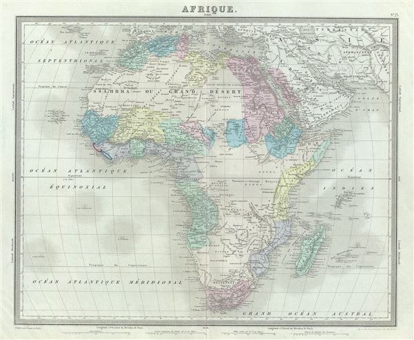
1874 Tardieu Map of Africa
Afrique-tardieu-1874$75.00

Title
Afrique.
1874 (undated) 15 x 18 in (38.1 x 45.72 cm) 1 : 26500000
1874 (undated) 15 x 18 in (38.1 x 45.72 cm) 1 : 26500000
Description
This is an attractive 1874 map of Africa by Ambroise Tardieu. It covers the entire continent in considerable detail considering the level to which it was explored at the time. It extends from the Mediterranean south to Cape town, including the island of Madagascar. Part of adjacent Arabia and Turkey are also featured. Though European colonies and outposts dot the coastlines, much of the interior remains unknown, even speculative.
Neither Mt. Kenya, first sighted by western explorers in 1849, nor Lake Victoria, the existence of which was confirmed by Stanley in 1862, appear on the map. Lake Marawi appears in its embryonic form. Numerous African tribes and nations are named throughout.
This map was prepared by Ambroise Tardieu and issued as plate 23 in his 1874 edition of Atlas Universel de Geographie Ancienne et Moderne.
CartographerS
Ambroise Tardieu (March 2, 1788 - January 17, 1841) was a prominent French cartographer and engraver operating in the late 18th and early 19th centuries. He was member of the large and prolific Tardieu family, which, for over 200 years, produced multiple skilled and active engravers. Tardieu's work is known for its beauty and accuracy as well as for its depth of detail. Tardieu's most important work is his version of John Arrowsmith's large format map of the United States, published in 1806. Ambroise Tardieu is eclipsed in fame by his son, artist and medical scholar, August Ambroise Tardieu. Ambroise Tardieu is also frequently confused with Jean Baptiste Pierre Tardieu, another unrelated French map and print engraver active in the early 19th century. More by this mapmaker...
Alexandre Aimé Vuillemin (1812 - 1880) was an engraver, publisher, and editor based in Paris, France in the middle of the 19th century. Despite a prolific publishing career, much of Vuillemin's life is shrouded in mystery. In 1852, he married Josephine Caroline Goret and they had at least one child, Ernestine Adèle Vuillemin, later in the same year. What is known is that his studied under the prominent French Auguste Henri Dufour (1798 - 1865). Vuillemin's most important work his detailed, highly decorative large format Atlas Illustre de Geographie Commerciale et Industrielle. Learn More...
Source
Furne, Jouvet et Cie Atlas Universel de Geographie Ancienne et Moderne (Paris), 1874.
Condition
Very good. Minor wear along original centerfold. Original platemark visible. Minor spotting.
References
Rumsey 4697.027 (1863 edition).