1939 Lucien Boucher Air France Pictorial Map of the World
AirFranceNovaetVetera-boucher-1939$1,900.00


Title
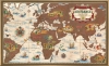
Air France. 'Nova et Vetera' sur la Vieille Terre des Chemins Nouveaux.
1939 (undated) 23.5 x 38.25 in (59.69 x 97.155 cm)
1939 (undated) 23.5 x 38.25 in (59.69 x 97.155 cm)
Description
This is a 1939 Lucien Boucher Air France pictorial map of the world on the eve of World War II. Created during an era when air travel was still relatively new, Boucher contrasts earlier modes of transportation with aviation. People from around the world travel via carriage, on horseback, and foot, and rarely venture far from their homes. Boucher's map traces Air France's routes across Europe, Africa, South America, the Middle East, and Southeast Asia, from Paris to Hong Kong, highlighting the 'ease' with which travelers could visit parts of the world that had previously felt inaccessible. The colorful vignettes of ships dotted across the world's oceans provide an even starker contrast, mainly when set against the massive silhouette of an airplane along the top border.
Publication History and Census
This map was created by Lucien Boucher and published by Air France in 1939. An example is part of the David Rumsey Map Collection, and it is not cataloged in OCLC.Cartographer
Lucien Boucher (1889 - 1971) was French cartoonist, artist, writer, and illustrator. Boucher was born in Chartres in 1889 and graduated from the École de Céramique de Sèvres. His work as a cartoonist appeared in the humorous weekly Le Rire. Starting in the 1920s he produced numerous pictorial posters inspired by the commercial promise of surrealism. Among them were a series of surrealistic planispheric and celestial maps drawn to illustrate the transportation networks of Air France. More by this mapmaker...
Condition
Very good. One minor marginal mend, else excellent.
References
Rumsey 8543.000.