This item has been sold, but you can get on the Waitlist to be notified if another example becomes available, or purchase a digital scan.
1846 Bradford Map of Alabama
Alabama-bradford-1846$200.00

Title
Alabama.
1846 (dated) 15 x 12 in (38.1 x 30.48 cm) 1 : 1650000
1846 (dated) 15 x 12 in (38.1 x 30.48 cm) 1 : 1650000
Description
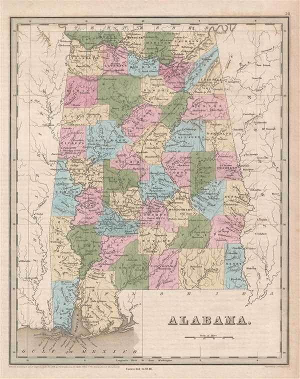
This is an 1846 Thomas G. Bradford map of Alabama. The map depicts the region from Mississippi to Georgia and from Tennessee to the Gulf of Mexico. As is the case with most maps in Bradford's A Universal Illustrated Atlas the recently constructed rail network features prominently in this depiction of Alabama.
Railroads in Alabama
The Tuscumbia Railway, though only 2.1 miles long, is illustrated. This railway was the first railroad chartered or constructed west of the Appalachian Mountains. Built from downtown Tuscumbia to the docks on the Tennessee River west of Sheffied, this railroad achieved remarkable success transporting cotton bales to the wharves on the Tennessee. The Tuscumbia Railway was only in operation from 1830 until 1832, when it was absorbed by the newly-constructed Tuscumbia, Courtland, and Decatur Railroad, which is also illustrated here. The Tuscumbia, Courtland, and Decatur was built in order to bypass Muscle Shoals, a stretch of shallow rapids that prevented river transport along the Tennessee River. The Montgomery and West Point Railroad (referred to as the Montgomery and Chattahoochee Railroad by Bradford) was chartered in January 1832 to build from Montgomery to Columbus, Georgia on the Chattahoochee River, but a second charter was granted in 1834 to change the destination to West Point, Georgia. The railroad was not completed until 1851 and would eventually be connected to Atlanta via the Atlanta and West Point Railroad in Georgia. The Montgomery and West Point Railroad played a critical role in the American Civil War, so much so that two separate Union raids targeted the railroad (one in 1864 and another in 1865) in an effort to disrupt Confederate supplies.
A highly detailed depiction of the state of Alabama, each county is illustrated, labeled, and shaded a different color to allow for easy differentiation. Numerous cities, towns, and villages are labeled, including Montgomery, Selma, Tuscaloosa, Talladega, and Mobile. Myriad rivers and creeks are illustrated and labeled, including the Tombigby River, the Tennessee River, the Alabama River, and the Chattahoochee River.
This map was engraved by George Boynton and published in the 1846 edition of Bradford and Goodrich's A Universal Illustrated Atlas.
CartographerS
Thomas Gamaliel Bradford (1802 - 1887) was born in Boston, Massachusetts, where he worked as an assistant editor for the Encyclopedia Americana. Bradford's first major cartographic work was his revision and subsequent republishing of an important French geography by Adrian Balbi, Abrege de Geographie published in America as Atlas Designed to Illustrate the Abridgment of Universal Geography, Modern and Ancient. Afterwards Bradford revised and expanded this work into his own important contributions to American cartography, the 1838 An Illustrated Atlas Geographical, Statistical and Historical of the United States and Adjacent Countries. Bradford's cartographic work is significant as among the first to record Texas as an independent nation. In his long career as a map publisher Bradford worked with William Davis Ticknor of Boston, Freeman Hunt of New York, Charles De Silver of Philadelphia, John Hinton, George Washington Boynton, and others. We have been able to discover little of Bradford's personal life. More by this mapmaker...
George Washington Boynton (fl. c. 1830 - 1850) was a Boston based cartographer and map engraver active in the first half of the 19th century. Boynton engraved and compiled maps for numerous publishers including Thomas Bradford, Nathaniel Dearborn, Daniel Adams, and S. G. Goodrich. His most significant work is most likely his engraving of various maps for Bradford's Illustrated Atlas, Geographical, Statistical, and Historical, of the United States and the Adjacent Countries and Universal Illustrated Atlas. He also engraved for the Boston Almanac. In 1835, Boynton is listed as an employee of the Boston Bewick Company, an engraving, stereotype, and printing concern based at no. 47 Court Street, Boston. Little else is known of his life. Learn More...
Source
Bradford, T. G. and Goodrich, S. G., A Universal Illustrated Atlas, exhibiting a Geographical, Statistical, and Historical view of the World, (Boston: Charles D. Strong) 1846.
The Universal Illustrated Atlas is one of the great American atlases of the first half of the 19th century. The atlas was first published in 1838 under the imprint of Charles D. Strong. It replaced and superseded Bradford's earlier smaller format Illustrated Atlas, Geographical, Statistical, and Historical, of the United States and the Adjacent Countries. Numerous reissues of the Universal Illustrated Atlas followed until about 1848. Although there are minor variations between the editions, most contain about 50 maps, the majority of which focus on the United States. Bradford's atlases are significant for recording North America during the Republic of Texas Era. In later editions, particularly the 1846 edition, Bradford illustrates the boom in railroad construction, possibly with the idea that his maps would aid travelers in planning journeys by rail. It was compiled by Thomas Gamaliel Bradford and Samuel Griswold Goodrich with most of the plates engraved by George Washington Boynton (fl. c. 1830 - 1850). Other contributors include Thomas Gordon (1778 - 1848), Fielding Lucas Jr. (1781 - 1854), Samuel Edward Stiles (1844 - 1901), Sherman and Smith (fl. c. 1829 - 1855), and Horace Thayer (1811 - c. 1874).
Condition
Very good. Even overall toning. Blank on verso.
References
Rumsey 0089.032 (1838 edition).