This item has been sold, but you can get on the Waitlist to be notified if another example becomes available, or purchase a digital scan.
1872 Mitchell Map of Alaska
Alaska-mitchell-1872$100.00

Title
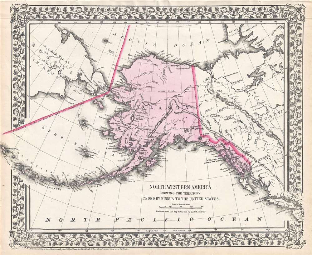
Northwesterb America Showing the Territory Ceded by Russia to the United States.
1872 (dated) 12 x 14.75 in (30.48 x 37.465 cm) 1 : 13000000
1872 (dated) 12 x 14.75 in (30.48 x 37.465 cm) 1 : 13000000
Description
This is an 1872 Samuel Augustus Mitchell Jr. map of Alaska. The map depicts the entire state of Alaska, along with eastern Siberia across the Bering Strait from Alaska, western Canada, and the Pacific coast of North America as far south as Vancouver Island and the Washington Territory. Numerous towns and villages are labeled in Alaska, as are several forts in the Yukon Territory and British Columbia. Islands are identified throughout, including the individual islands in the Aluetians. The whole is surrounded by the vine motif border that was characteristic of Mitchell maps between 1865-1880.
This map was created by S.A Mitchell, Jr. and issued in the 1872 edition of Mitchell's New General Atlas.
This map was created by S.A Mitchell, Jr. and issued in the 1872 edition of Mitchell's New General Atlas.
Cartographer
Samuel Augustus Mitchell (March 20, 1792 - December 20, 1868) began his map publishing career in the early 1830s. Mitchell was born in Bristol, Connecticut. He relocated to Philadelphia in 1821. Having worked as a school teacher and a geographical writer, Mitchell was frustrated with the low quality and inaccuracy of school texts of the period. His first maps were an attempt to rectify this problem. In the next 20 years Mitchell would become the most prominent American map publisher of the mid-19th century. Mitchell worked with prominent engravers J. H. Young, H. S. Tanner, and H. N. Burroughs before attaining the full copyright on his maps in 1847. In 1849 Mitchell either partnered with or sold his plates to Thomas, Cowperthwait and Company who continued to publish the Mitchell's Universal Atlas. By about 1856 most of the Mitchell plates and copyrights were acquired by Charles Desilver who continued to publish the maps, many with modified borders and color schemes, until Mitchell's son, Samuel Augustus Mitchell Junior, entered the picture. In 1859, S.A. Mitchell Jr. purchased most of the plates back from Desilver and introduced his own floral motif border. From 1860 on, he published his own editions of the New General Atlas. The younger Mitchell became as prominent as his father, publishing maps and atlases until 1887, when most of the copyrights were again sold and the Mitchell firm closed its doors for the final time. More by this mapmaker...
Source
Mitchell's New General Atlas, containing maps of the various countries of the World, plans of cities, etc., (1872 edition).
Condition
Very good. Even overall toning. Blank on verso.
References
Rumsey 0579.045 (1868 edition).