This item has been sold, but you can get on the Waitlist to be notified if another example becomes available, or purchase a digital scan.
1898 U.S. Geological Survey Map of Alaska Gold and Coal Fields
AlaskaGoldCoalFields-usgs-1898$150.00

Title
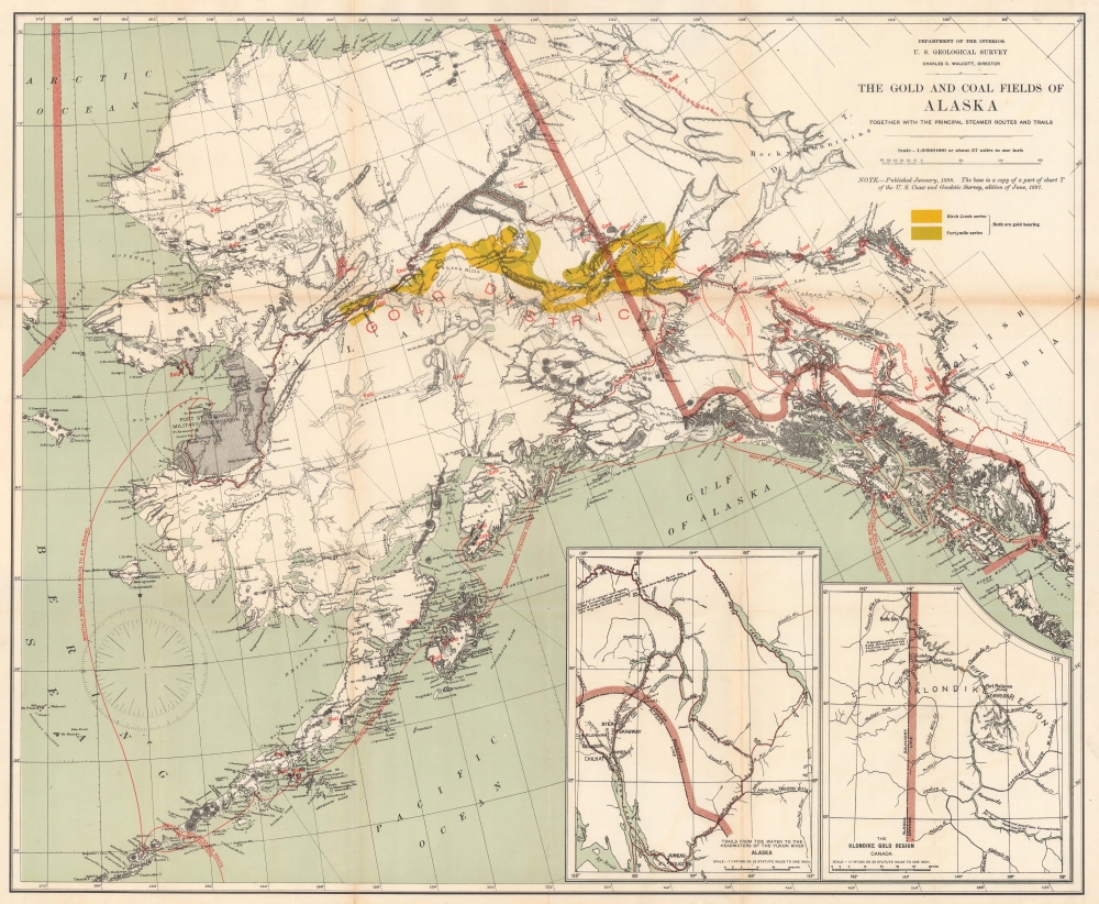
The Gold and Coal Fields of Alaska Together with the Principal Steamer Routes and Trails.
1898 (dated) 24 x 29 in (60.96 x 73.66 cm) 1 : 3600000
1898 (dated) 24 x 29 in (60.96 x 73.66 cm) 1 : 3600000
Description
This is an 1898 U.S. Geological Survey map of Alaska highlighting gold and coal fields. Published two years after the initial gold discovery in the Klondike that ignited the Yukon Gold Rush, the map highlights gold fields across the state and the Yukon, along with coal deposits.
This map relates not only the Klondike gold fields but also a vaster gold region stretching across Alaska. 'New Alaska Gold Fields' were discovered in the southern part of the Seward Peninsula around Nome (founded in 1901 three years after this map’s publication) in September 1898, setting off another gold rush. With the Klondike already inundated with diggers by 1898, new sources of the precious metal were sought in Alaska's wilderness. News of the abundance of gold around Nome - often found on the beach in abundance without the need for a mining or a claim - spread quickly and caused great excitement. Thousands of miners descend on the region from Dawson City and elsewhere in Alaska and Canada. The effect was so profound that the gold rush around Nome effectively ended the Klondike Gold Rush, shifting attention to the west and north.
However, the easily accessible gold around Nome was quickly snapped up, and even the discovery of new deposits could not halt the inevitable decline. In 1902, gold was discovered near Fairbanks and a new gold rush began, shifting attention deep into the interior. Nome's population, as high as 20,000 at one point, was barely one-tenth of that number by 1910 and had shrunk below 1,000 by 1920.
Another gold rush around the Copper River is the focus of the inset map at bottom-left. The presence of Indian villages on this map hints at the prominent and continued indigenous presence. White settlers first set up in this region as a stopover point for prospectors on their way to the Klondike. But these prospectors began to search the local area as well and by 1900 had found gold along local riverbeds. The inevitable tidal wave of miners arrived, setting up new towns nearly overnight, especially Copper Center. The miner population waxed and waned in the following years as deposits were exhausted and new placers periodically discovered. The area also saw coal and oil booms in the first decade of the 20th century.
A Closer Look
Yellow and green highlight the Birch Creek series and the Fortymile series (both areas of rich gold deposits), while red stippling marks gold deposits outside these regions. Red lines highlight trails from Sitka into the Klondike and further into Alaska. Among these are the Bound Trail, Dalton Trail, and the Telegraph Trail. The Copper River Trail appears as well, along with gold deposits along the White River. Red text marks gold and coal deposits throughout. Two insets appear in the lower right corner and depict the 'Trails from Tide Water to the Headwaters of the Yukon River Alaska' and 'The Klondike Gold Region Canada'.Gold Rushes in Alaska
Gold was first discovered near the mouth of the Klondike River in August 1816 by a party of Tagish American Indians. The original Yukon Gold Discovery was made in 1896 in the Bonanza (Rabbit) Creek area, but it quickly became apparent that the gold deposits were far vaster. Word traveled quickly and by July 1897 a stampede of prospectors from throughout the United States and Canada was headed to the Klondike. This was compounded by the fact that a series of bank failures in 1897 left the American economy in disarray and many out of work. Over 40,000 prospectors and their families moved to Alaska, generally by way of Seattle or San Francisco. The Klondike Gold Rush drew such notables as future U.S. President William H. Taft, adventurer Frederick Russell Burnham, and author W. W. White.This map relates not only the Klondike gold fields but also a vaster gold region stretching across Alaska. 'New Alaska Gold Fields' were discovered in the southern part of the Seward Peninsula around Nome (founded in 1901 three years after this map’s publication) in September 1898, setting off another gold rush. With the Klondike already inundated with diggers by 1898, new sources of the precious metal were sought in Alaska's wilderness. News of the abundance of gold around Nome - often found on the beach in abundance without the need for a mining or a claim - spread quickly and caused great excitement. Thousands of miners descend on the region from Dawson City and elsewhere in Alaska and Canada. The effect was so profound that the gold rush around Nome effectively ended the Klondike Gold Rush, shifting attention to the west and north.
However, the easily accessible gold around Nome was quickly snapped up, and even the discovery of new deposits could not halt the inevitable decline. In 1902, gold was discovered near Fairbanks and a new gold rush began, shifting attention deep into the interior. Nome's population, as high as 20,000 at one point, was barely one-tenth of that number by 1910 and had shrunk below 1,000 by 1920.
Another gold rush around the Copper River is the focus of the inset map at bottom-left. The presence of Indian villages on this map hints at the prominent and continued indigenous presence. White settlers first set up in this region as a stopover point for prospectors on their way to the Klondike. But these prospectors began to search the local area as well and by 1900 had found gold along local riverbeds. The inevitable tidal wave of miners arrived, setting up new towns nearly overnight, especially Copper Center. The miner population waxed and waned in the following years as deposits were exhausted and new placers periodically discovered. The area also saw coal and oil booms in the first decade of the 20th century.
Publication History and Census
This map was created and published by the U.S. Geological Survey in 1898. An example is part of the David Rumsey Map Collection. It is well represented in institutional collections.Cartographer
The United States Geological Survey (1878 - Present), aka the U.S.G.S., is a scientific agency of the United States government, which was founded in 1879. USGS scientists study the landscape of the United States, its natural resources, and the natural hazards that threaten it. The organization has four major science disciplines: biology, geography, geology, and hydrology. It is a bureau of the United States Department of the Interior and is the department's only scientific agency. More by this mapmaker...
Condition
Good. Wear and toning along original fold lines. Old repair to closed tear extending 1/16th of an inch into printed area from bottom margin. Slight loss at fold intersections. Fold intersections reinforced. Small area of infill at a fold intersection.
References
Rumsey 1091.001. OCLC 70282048.