This item has been sold, but you can get on the Waitlist to be notified if another example becomes available, or purchase a digital scan.
1891 Rand McNally Map of Northwestern Africa : Algeria, Morocco and Tunisia
Algeria-randmcnally-1895$37.50

Title
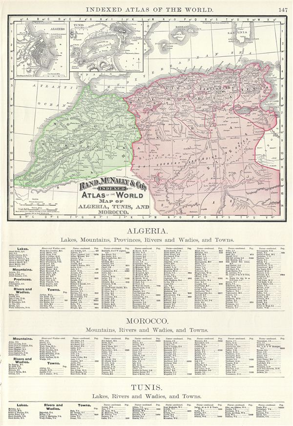
Map of Algeria, Tunis, and Morocco.
1891 (dated) 10.5 x 13.5 in (26.67 x 34.29 cm) 1 : 6950000
1891 (dated) 10.5 x 13.5 in (26.67 x 34.29 cm) 1 : 6950000
Description
This is a beautiful example of Rand McNally and Company's 1891 map of northwest Africa. Featuring Algeria, Morocco and Tunisia, it covers from the Mediterranean Sea to the Sahara. Two inset maps in the upper left quadrant feature Algiers and Tunis. After its conquest by the French in 1830, Algeria became an attractive destination for European immigrants. However the majority indigenous Muslim population was dissatisfied with the political system. This dissatisfaction would ultimately trigger the Algerian War and lead to Algeria's independence from France. This map of Algeria, Morocco and Tunis, printed on half the page unlike most other maps from this atlas, contains a list of islands, lakes, mountains, rivers, towns, etc. in the lower half of the page, below the printed map. Color coded according to regions, the map notes several towns, cities, rivers, mountains, and various other topographical details with relief shown by hachure. This map was issued as plate no. 147 in the 1895 issue of Rand McNally and Company's Indexed Atlas of the World - possibly the finest atlas Rand McNally ever issued.
Cartographer
Rand, McNally and Co. (fl. 1856 - present) is an American publisher of maps, atlases and globes. The company was founded in 1856 when William H. Rand, a native of Quincy, Massachusetts, opened a print shop in Chicago. Rand hired the recent Irish immigrant Andrew McNally to assist in the shop giving him a wage of 9 USD per week. The duo landed several important contracts, including the Tribune's (later renamed the Chicago Tribune) printing operation. In 1872, Rand McNally produced its first map, a railroad guide, using a new cost effective printing technique known as wax process engraving. As Chicago developed as a railway hub, the Rand firm, now incorporated as Rand McNally, began producing a wide array of railroad maps and guides. Over time, the firm expanded into atlases, globes, educational material, and general literature. By embracing the wax engraving process, Rand McNally was able to dominate the map and atlas market, pushing more traditional American lithographic publishers like Colton, Johnson, and Mitchell out of business. Eventually Rand McNally opened an annex office in New York City headed by Caleb S. Hammond, whose name is today synonymous with maps and atlases, and who later started his own map company, C. S. Hammond & Co. Both firms remain in business. More by this mapmaker...
Source
Rand McNally & Co., Foreign Countries. Rand, McNally & Co's Indexed Atlas of the World (Complete in Two Volumes)…, (Chicago) 1895.
Condition
Very good. Text on verso and at bottom of page, below map.
References
Rumsey 3565.039 (1897 edition). Philip (atlases) 1026 (1898 edition).