1880 Abbé Faure Allegorical Map of the Empire of Vice
AllegoriqueVice-faure-1880$5,000.00

Title
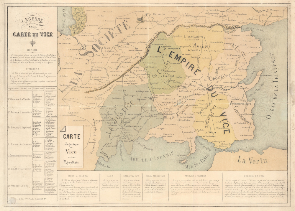
Carte allégorique du Vice et de ses Résultats.
1880 (undated) 18.75 x 25.75 in (47.625 x 65.405 cm)
1880 (undated) 18.75 x 25.75 in (47.625 x 65.405 cm)
Description
This is a rare c. 1880 broadside allegorical map of Vice made by the French Catholic curate Abbé Faure. The image reflects the tensions facing French Catholicism, which was undergoing a transformation and gradual decline, caught between the legacy of tradition and the emergence of a secular Republican state.
Below, the Strait of Sighs separates the Empire of Vice from Virtue (La Vertu). The Ocean of Sadness(Océan de la Tristesse) and the Sea of Boredom (Mer de l'Ennui) and the Sea of Infamy (Mer de l'Infamie) define Empire's other borders.
The Empire of Vice
The map presents an allegorical land separated into La Société and the L'Empire du Vice. The Empire is separated from Society by the Mountains of Duty and Moral Obligation (Les Montagnes du Devoir). Justice (La Justice) borders the Empire along with the Dell of Danger (Vallon du Danger) and the Valley of Temptation (Vallée de la Tentation). The Empire of Vice is divided into 7 provinces (départements), each of which corresponds with one of the Seven Deadly Sins:- Anger (La Colère), cities of Vengeance and Cruelty
- Greed (L'Avarice), cities of Insatiability and Egotism
- Envy (L'Envie), cities of Jealousy and Hatred
- Pride (L'Orgueil), cities of Vanity (capital), Atheism and Mockery
- Lust (La Luxure), cities of Adultery and Prostitution
- Sloth (La Paresse), cities of Idleness and Negligence
- Gluttony (La Gourmandise), cities of Rapacity and Drunkenness
Below, the Strait of Sighs separates the Empire of Vice from Virtue (La Vertu). The Ocean of Sadness(Océan de la Tristesse) and the Sea of Boredom (Mer de l'Ennui) and the Sea of Infamy (Mer de l'Infamie) define Empire's other borders.
Justice and Society
Just outside the borders of the Empire of Vice lies the Dale of Danger. Performance (le Spectacle), Fashion (la Mode), and Novels (les Romans) appear within the Dale, which is right next to the Valley of Temptation. Cities within Justice include Circuit Court (Cour d'Assises), Labor Camp (Le Bagne), and The Gallows (L'Echafaud). The Plains of Hope lie just inside the borders of Society and include Liberty (la Liberté), Friendship (l'Amitié), and Forgiveness (le Pardon). Family (La Famille), Religion (La Religion), and Honor (L'Honneur) are the only major cities within Society. The only railroad in Society connects Family with the Warning Train Station in Lust along the Escape railroad line.The Tables
Tables to the left and below the map elucidate the content and meaning.Publication History and Census
This map was created by Abbé Jean-Baptiste Faure and published by Veuve Petit in Clermont-Ferrand, France, c. 1880. We are aware of only one other cataloged example, part of the David Rumsey Map Collection.Cartographer
M. l'Abbé Jean-Baptiste Faure (November 11, 1833 - 189?) was a French catholic clergyman. Born in Clermont-Ferrand, France, Faure attended school in Clermont-Ferrand before joining the clergy. He was the curate at Saint-Etienne-du-Mont in Paris near the Panthéon during the 1871 Siege of Paris and the Paris Commune. On January 25, 1885, Abbé Faure became the curate at La Grande Roquette, then the prison that was the location of executions by guillotine in Paris. During his 6 years ministering to the prisoners at La Grande Roquette, Abbé Faure witnessed 20 executions. He published a memoir about his time working in La Grande Roquette entitled Au Pied de l'Echafaud: Souvenirs de La Roquette. More by this mapmaker...
Condition
Good. Wear along original fold lines. Old verso repairs to tears extending 1 inch and 1.25 inches respectively into the printed area from the bottom margin. Some soiling.
References
Rumsey 11860.000.