
This item below is out of stock, but another example (left) is available. To view the available item, click "Details."
Details
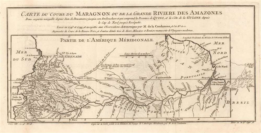
1780 Bellin Map of the Amazon River
$300.00
1780 Bellin Map of the Amazon River
Amazon-bellin-1780$150.00

Title
Carte du Cours du Maragnon ou de la Grande Riviere des Amazones Dans sa partie navigable depuis Jaen de Bracamoros jusqu'a son Embouchure et qui comprend la Province de Quito, et la Côte de la Guïane depuis le Cap de Nord jusqu'à Esséquebè.
1780 (undated) 7 x 15 in (17.78 x 38.1 cm) 1 : 12000000
1780 (undated) 7 x 15 in (17.78 x 38.1 cm) 1 : 12000000
Description
This is a fascinating 1780 map of the Amazon river basin, spanning the breadth of the South American continent, embracing Peru, Ecuador, Colombia, Venezuela, Brazil, Guyana, Suriname, and French Guiana. It displays the mapping of the great river produced in 1743 by the French Geodesic Mission under Charles Marie de La Condamine, which still represented the state of the art. This exhaustive mapping of the Amazon and its tributaries is shown overlaying another map of the Amazon, this one executed in 1707 by the Jesuit Father Samuel Fritz. His mapping of the Amazon had been the first accurate one to be produced, and so to have it compare so poorly to Condamine's was to present a flourish on behalf of modern, French scientific geography.
Goals of the The French Geodesic Mission: Earth! Just How Round Is It, Anyway?
Led by Charles Marie de La Condamine, the Geodesic Mission was intended to determine whether Newton's theory on the oblate nature of the globe - that it was not truly spherical, but slightly flattened at the poles (narrower from pole to pole than across the equator). Scientists disagreed: Cassini, for example, theorized that the distance was greater at the poles. To resolve the issue, it would be necessary to measure a degree of arc near the Equator, measure a degree of arc nearer the North Pole, and compare the two. Condamine's part of the project was to survey a measurable length of a meridian along the equator. This required that Condamine and his colleagues precisely survey a length of the high valleys of the Andes - literally the only place in the world where such a survey was practicable in the 1730s. Ultimately, the project determined that the Earth is indeed not perfectly spherical but is oblate, i.e. flattened at the poles - as per Newton.Publication History and Census
The separate map appears on the market from time to time but is neglected in institutional collections: OCLC lists only four examples. La Harpe's Abrégé de l'histoire générale des voyages is well represented in institutions, however.CartographerS
Jacques-Nicolas Bellin (1703 - March 21, 1772) was one of the most important cartographers of the 18th century. With a career spanning some 50 years, Bellin is best understood as geographe de cabinet and transitional mapmaker spanning the gap between 18th and early-19th century cartographic styles. His long career as Hydrographer and Ingénieur Hydrographe at the French Dépôt des cartes et plans de la Marine resulted in hundreds of high quality nautical charts of practically everywhere in the world. A true child of the Enlightenment Era, Bellin's work focuses on function and accuracy tending in the process to be less decorative than the earlier 17th and 18th century cartographic work. Unlike many of his contemporaries, Bellin was always careful to cite his references and his scholarly corpus consists of over 1400 articles on geography prepared for Diderot's Encyclopedie. Bellin, despite his extraordinary success, may not have enjoyed his work, which is described as "long, unpleasant, and hard." In addition to numerous maps and charts published during his lifetime, many of Bellin's maps were updated (or not) and published posthumously. He was succeeded as Ingénieur Hydrographe by his student, also a prolific and influential cartographer, Rigobert Bonne. More by this mapmaker...
Charles Marie de La Condamine (January 28, 1701 – February 4, 1774) was a French explorer, geographer, and mathematician. He was a contemporary and friend of Voltaire, with whom he successfully gamed the French lottery. He took part in the French Geodesic Mission, tasked with performing measurements near the equator in order to test Newton's theory regarding the oblate shape of the globe. In conjunction with similar measurements performed by an expedition to Lapland, by Maupertuis, Clairaut, and Le Monnier, the Geodesic Mission was able to declare Newton's theory correct. This project resulted in the first map of the Amazon region based on astronomical observation. (Condamine also produced, based on experiences in this journey, the first scientific paper on the properties of rubber.) Learn More...
Source
De la Harpe, Abrégé de l'histoire générale des voyages. - Paris, 1780
Condition
Excellent condition, with full margins and no repairs.
References
OCLC 163341299.