This item has been sold, but you can get on the Waitlist to be notified if another example becomes available, or purchase a digital scan.
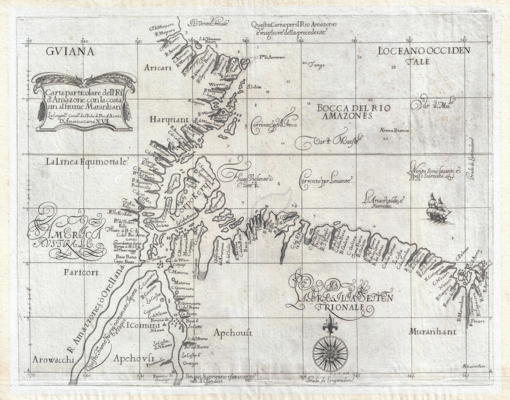
1647 Dudley Nautical Map of the Mouth of the Amazon River
Amazon-dudley-1647$1,125.00

Title
Carta Particolare dell'Rio d'Amazone con la costa sin al fiume Maranhan.
1647 (undated) 14.75 x 19 in (37.465 x 48.26 cm) 1 : 1550000
1647 (undated) 14.75 x 19 in (37.465 x 48.26 cm) 1 : 1550000
Description
This is a beautiful, first edition example of Robert Dudley's rare 1647 nautical chart of the mouth of the Amazon River, Brazil. It appeared in Dudley's Dell'Arcano del Mare, first nautical atlas to cover the whole world, and the first to be produced by an Englishman. It was also the first sea atlas to consistently employ the Mercator projection, making the work useful in actual navigation.
In addition to forts Orange and Nassau, the chart also identifies the Dutch supply depot of Waterhuis; the city of 'Pinaro' near the mouth of the Maranhan River may reflect Portuguese settlement in the Maranhão.
In 1629, Portuguese forces under Pedro de Teixeira drove the Dutch out of the region. It is just credible that Dudley may have had access to the work of Teixeira's chronicler, Cristóbal de Acuña, but the absence of Para - the starting point of Acuña and Teixeira's journey up the Amazon - from the mouth of the river argues against such.
A Closer Look
It covers the region surrounding the mouth of the Amazon from French Guiana (Guiana) to the mouth of the Mearim River and the Baía de São Marcos in Brazil. Although covering only the mouth of the Amazon River, this is one of the earliest maps to show any part of this area at a large scale. The whole is rendered in the inimitable style of Antonio Francesco Lucini, who engraved all the charts appearing in Arcano del Mare. (A monumental effort - the plates required five thousand pounds of copper to complete the work.) Lucini's superb calligraphy and balanced composition - including attractively-engraved ships and compass roses - contribute to making Dudley's charts some of the most elegant, distinct, and desirable printed cartographic works of the 17th century.Europeans in Brazil
The mouth of the Amazon had been the subject of European exploration as far back as the 16th century, notably by Francisco de Orellana between 1541 and 1546. It was he who named the river, having heard of all-female (Amazon!) tribes in the vicinity. It would be the Dutch, however, who pioneered the establishment of trade to the interior, and this chart reflects their efforts.Sources
Dudley sailed on expeditions across the Atlantic, and his work reflects sensitivity to the needs of the mariner. Of his data, however, only two charts were derived substantially from his own journeys (the charts pertaining to the coast of Guiana and the mouth of the Orinoco River). As is the case with many of his American charts, Dudley drew heavily on the best Dutch sources available, in most cases the work of Hessel Gerritsz. The general outline here resembles the Dutch chartmaker's more general 1625 map, appearing in Johannes de Laet's Nieuwe wereldt, ofte, Beschrijvinghe van West-Indien. Dudley focuses on a narrower area, revealing greater detail than Gerritsz. The Dutch forts along the Xingu River shown here, Orange and Nassau, did not appear on Gerritsz' 1625 chart but they were discussed in De Laet's accompanying text accompanying - a circumstance which may explain Dudley's having transposed the locations of the two forts. These, De Laet noted, were settled in 1599 or 1600 by merchants from Vlissingen.In addition to forts Orange and Nassau, the chart also identifies the Dutch supply depot of Waterhuis; the city of 'Pinaro' near the mouth of the Maranhan River may reflect Portuguese settlement in the Maranhão.
In 1629, Portuguese forces under Pedro de Teixeira drove the Dutch out of the region. It is just credible that Dudley may have had access to the work of Teixeira's chronicler, Cristóbal de Acuña, but the absence of Para - the starting point of Acuña and Teixeira's journey up the Amazon - from the mouth of the river argues against such.
Publication History and Census
This chart was engraved in copper by Antonio Francesco Lucini in 1647 for inclusion in the first edition of Robert Dudley's Dell'Arcano del Mare. A further 1661 edition of the chart exists, distinguishable by the presence of the notation 'L.°6°' in the cartouche. We note a single example of the work cataloged in OCLC in the collection at the Bayerische Staatsbibliothek. Separate examples of the chart are listed in the collections of the Leventhal Map Center at the Boston Public Library and the British Library, but they occasionally appear on the market.CartographerS
Sir Robert Dudley (August 7, 1573 - September 6, 1649) was an English explorer and cartographer, the publisher of the Dell’Arcano de Mare, one of the greatest nautical atlases of all time. He was the illegitimate son of Robert Dudley, 1st Earl of Leicester (a favorite of Queen Elizabeth I) and Douglas Sheffield, the widow of John Sheffield, 2nd Baron Sheffield. In 1594, Dudley led an expedition across the Atlantic, with the intent of harassing Spanish merchantmen. His expedition met with a series of misfortunes, but successfully returned to England the following year. In 1596, Dudley joined an expedition led by Robert Devereux, 2nd Earl of Essex, against Cadiz. He served as the commander of the Nonpareil, and was knighted for his conduct in the capture of Cadiz. In 1603, Dudley made an attempt to establish his legitimacy at court and gain several inheritances, after being (possibly erroneously) informed that his parents had been secretly married. No concrete proof of the marriage could be furnished, thus the judgement was handed down against him in May 1605. Dudley left England in July of the same year, with his lover and cousin Elizabeth Southwell, who was disguised as his page. They married in Lyon in 1606 having received a papal dispensation. The couple settled in Florence, where Dudley began using his father’s title, Earl of Leicester, and his uncle’s, Earl of Warwick. In Florence, Dudley designed and built warships for the arsenal at Livorno and became a naval advisor to Ferdinand I, Grand Duke of Tuscany. In 1607, James I revoked Dudley’s travel license once ordered that he return to provide for his deserted wife and family. Dudley refused, was subsequently labeled an outlaw, and his estate was confiscated. By far Dudley’s most important work was the Dell’Arcano del Mare (Secrets of the Sea). His most celebrated achievement, is the atlas of sea charts of the world which accompanied the work. This maritime atlas was the first nautical atlas of the entire world in print, the first made by an Englishman, the first to show prevailing winds and currents, and the first to use the Mercator projection throughout. More by this mapmaker...
Antonio Francesco Lucini (January 1, 1610 - 1661), a.k.a. Anton, was an Italian engraver and printmaker. Lucini was born in Florence born in 1605. Lucini initially studied engraving with Stefano della Bella (1610 - 1664) under Jacques Callot (c 1592 - 1635), who lived in Florence from 1612 to 1621. He is recorded in 1616 as Callot's assistant in Florence. After 1621, he joined flowed Callot in Nancy to continue his training. He returned to Florence sometime before 1631, when he published a series of plates on the Great Siege of Malta. He is best known in cartographic circles as the engraver for Sir Robert Dudley's seminal maritime atlas Dell'Arcano del Mare (Of the Mysteries of the Sea), published in Florence in 1645 - 1646. The 200 engraved plates and 146 charts which Lucini produced for Dudley occupied 12 years occupied 12 years of his life and consumed some 5000lbs of copper. The engravings exhibit Lucini’s masterful craftsmanship and are outstanding examples of Italian Baroque engraving. Indeed, while Dudley was a master chartmaker, it is Lucini's virtuoso engraving and fine calligraphy that most define Dudley's work. Learn More...
Source
Dudley, R., Dell'Arcano del Mare, (Florence) 1645.
Dell’Arcano del Mare (Secrets of the Sea) is a six volume 17th century maritime encyclopedia by English nobleman Sir Robert Dudley (1573 - 1649). It is considered to be one of the most important maritime atlases of all time, the first of its kind in print: the first sea atlas to treat the entire world (not just Europe), the first by an Englishman, the first to illustrate prevailing winds and currents, and the first to universally employ a Mercator projection. The charts themselves are notable for being all new works, created by Dudley based upon a lifetime of collecting maritime data. All of the roughly 130 known charts in the Dell’Arcano del Mare were engraved in the Italian baroque aethetic by Antonio Francesco Lucini, a Florentine master engraver. It is said that the work took Lucini 12 years and consumed more than 5000lbs of copper. It was published in Florence between 1645 and 1646 in six folio volumes. Another edition was issued in 1661 but contained fewer charts.
Condition
Excellent. Printer's crease with no loss. Light toning and soiling to margins, few unobtrusive spots.
References
OCLC 164795308. Boston Public Library, Leventhal Map Center, G1059 .D84 1647. Shirley, R., Maps in the atlases of the British Library, M.Dud-1a, 128.