1780 Bowles Map of North America and South America
America-bowles-1780$2,950.00

Title
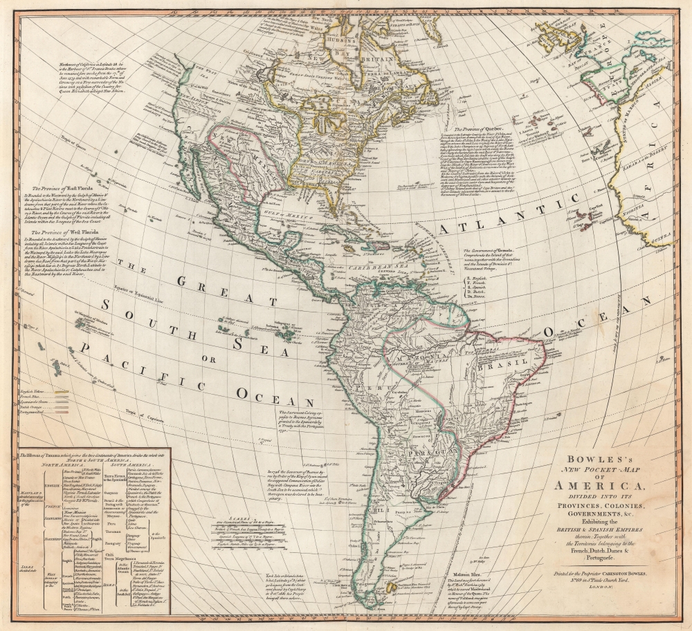
Bowles's New Pocket-Map of America, Divided into its Provinces, Colonies, Governments, etc. Exhibiting the British and Spanish Empires therein; Together with the Territories belonging to the French, Dutch, Danes, and Portuguese.
1780 (undated) 20 x 21.5 in (50.8 x 54.61 cm) 1 : 24300000
1780 (undated) 20 x 21.5 in (50.8 x 54.61 cm) 1 : 24300000
Description
This is a c. 1780 Carington Bowles map of North America and South America. The map depicts the increasingly complex and unstable political situation following the French and Indian War (1754 - 1763). It also highlights French and English ambitions for an inland Northwest Passage via Hudson Bay and speculations about a 'Sea of the West' dominating the Pacific Northwest - one of the last and greatest cartographic myths of the 18th century.
A Closer Look
Bowles uses color to define the colonial claims of European powers: English (yellow), French (blue), Spanish (green), Dutch (orange), and Portuguese (red). Text blocks discuss the Floridas, Quebec, colonial holdings in South America (particularly 'Buenos Ayres'), and the discovery of York Isle.North America
Cities, towns, and villages, including New York, Boston, Philadelphia, Williamsburg, and Charles Town, are labeled, along with rivers, lakes, and mountain ranges. Native American nations are named throughout. Greenland appears near the top border.The British Colonies
Bowles devotes considerable attention to the British colonies in North America - a point of great interest to his audience. Virginia, North Carolina, South Carolina, and Georgia stretch from the Atlantic to the Mississippi, reflecting their original coast-to-coast charters. Pennsylvania and New York appear below oversized iterations of Lake Erie and Lake Ontario. Southern Florida, at the time a British possession, is represented as an archipelago (the Everglades befuddled generations of cartographers).Dreaming of a Northwest Passage
In northern Canada, Hudson's Bay is well mapped, with rivers, islands, and settlements illustrated. A note to the left states, 'All the Bays and Inlets on the West side of Hudson's Bay have been visited without appearance of success in the several attempt for the discovery of a Northwest Passage.' Over the preceding decades, numerous expeditions were launched to discover a Northwest Passage, long speculatively included in maps, despite never being discovered. Nonetheless, Bowles includes a suggestion of a Northwest Passage using the Port Nelson River as the gateway. This river connects with the 'L. Bourbon' which in turn connects with a 'system of great lakes' in central Canada that are tantalizingly close to the speculative Sea of the West. A river heads southwest from 'L. Ouinipique' (Lake Winnipeg) and traverses the Rocky Mountains before disappearing into the nebulously-drawn 'Western Sea'. Another enticing river system flows east from Lake Winnipeg through another 'system of lakes' to Lake Superior, suggesting a connection between Hudson Bay and the St. Lawrence River.The Sea of the West
A magnificent inland sea appears regularly in the American Pacific Northwest on maps created in the mid to late 18th century. This massive and apocryphal body of water, generally referred to as the 'Sea of the West' or 'Mer de l'Ouest', can trace its origins to the French cartographer Guillaume De L'Isle (1675 - 1726). De L'Isle himself never published a map incorporating a 'Sea of the West' (perhaps suggesting doubt?), but a manuscript map illustrating the Sea of the West did appear in his notes. It may be that De L'Isle was inspired by a c. 1630 Thames school manuscript map, now located at Yale, that features a geographically similar body of water described as a 'Branch of the South Sea', possibly a revisionist perspective on Verrazano's Sea. The earliest printed map to include the Sea of the West was probably Jean-Baptiste Nolin's 1742 L'Amerique ou le Nouveau Continent. It has been suggested that Nolin copied the relevant cartography from De l'Isle's manuscript, but it is more likely that information about the 'sea' verbally leaked, as Nolin's sea does not resemble De L'Isle's in any significant way. The first publication of the 'Sea of the West' a la De L'Isle appeared when Joseph Nicholas (1688 - 1768), going through his deceased elder brother's notes, discovered the aforementioned manuscript map. At the time, Joseph Nicholas was working in St. Petersburg with the Tsar's Academy of Sciences. There, he had access to new information absconded from the Vitus Jonassen Bering's (1681 - 1741) Great Northern Expedition. He was keen to publish this before an official map was released. In 1752, Joseph Nicholas partnered with Philippe Buache (1700 - 1773) to do just that, using Guillaume De L'Isle's posthumous notes to fill in the American side of the map. The Buache/De L'Isle map featured an accurate Siberian Arctic from Bering, but in the Americas, it included a monumental 'Mer d'Ouest' or bay suggestive of a viable Northwest Passage. Although De l'Isle and Buache were accused of fraud, the Sea of the West appeared on many maps, with some editions even post-dating Cook.Drake's Harbor and New Albion
The 'Harbor of Sr. Francis Drake' appears along the west coast, north of what is labeled here as California. Often believed to be San Francisco Bay, Drake supposedly wintered here in 1579 and, while there, named the region New Albion and claimed it for England.Central America and the West Indies
Mexico City, Vera Cruz, and Oaxaca (Guaxaca) are labeled, along with the small but important island of Cozumel. Lake Nicaragua is illustrated, and Nicaragua, Honduras, Guatemala, Costa Rica, and Panama are identified. Instead of using color to identify colonial holdings in the West Indies, Bowles uses letters to mark English ('E'), French ('F'), Dutch ('D'), Danish ('Da'), and Spanish ('S') colonies.South America
South America receives the same level of attention granted to North America, although perhaps less apocryphal cartography. The Amazon River and its tributaries dominate the northern portion of the continent. Cities, towns, and missions appear along the west coast and along the Paraná and Uruguay Rivers. Bowles retains the apocryphal Laguna de Xarayes.Laguna de Xarayes
The mythical Laguna de Xarayes is illustrated here as the northern terminus, or source, of the Paraguay River. The Xarayes, a corruption of 'Xaraies' meaning 'Masters of the River,' were an indigenous people occupying what are today parts of Brazil's Matte Grosso and the Pantanal. When Spanish and Portuguese explorers first navigated up the Paraguay River, as always in search of El Dorado, they encountered the vast Pantanal flood plain at the height of its annual inundation. Understandably misinterpreting the flood plain as a gigantic inland sea, they named it after the local inhabitants, the Xaraies. The Laguna de los Xarayes almost immediately began to appear on early maps of the region and, at the same time, to take on a legendary quality. Later missionaries and chroniclers, particularly Díaz de Guzman, imagined an island in this lake and curiously identified it as an 'Island of Paradise,'...an island [of the Paraguay River] more than ten leagues [56 km] long, two or three [11-16 km] wide. A very mild land rich in a thousand types of wild fruit, among them grapes, pears, and olives: the Indians created plantations throughout, and throughout the year sow and reap with no difference in winter or summer,... the Indians of that island are of good will and are friends to the Spaniards; Orejón they call them, and they have their ears pierced with wheels of wood... which occupy the entire hole. They live in round houses, not as a village, but each apart though keep up with each other in much peace and friendship. They called of old this island Land of Paradise for its abundance and wonderful qualities.
Publication History and Census
This map was published by Carington Bowles c. 1780. We note a single cataloged example of the present edition, located at Reed College. At least three states of the map were published. The first was published by John Bowles and bears an elaborate title and scale cartouche. The second (present example) was published by Carington Bowles and does away with the elaborate cartouches and his father's imprint, replacing it with a more austere title and his own imprint. The third state is dated April 1784 and recognizes the nascent United States.Cartographer
The Bowles Family (fl. c. 1714 - 1832) were publishers and map sellers active in London from c. 1714 to c. 1832. The firm, under Thomas Bowles (fl. 1714 - 1763), John Bowles (1701 - 1779), Carrington Bowles (1724 - 1793), and as Bowles and Carver (fl. 1794 - 1832), produced a massive corpus of work that included numerous atlases, pocket maps, and wall maps. The Bowles publishing tradition was kept alive for four generations, starting with Thomas Bowles, a print engraver active in the late 17th century. His son, Thomas Bowles II, produced the firm's first maps at St. Paul's Churchyard, London. Thomas's brother, John Bowles (a.k.a. 'Old John Bowles' or 'Black Horse Bowles'), was also an active publisher established at no. 13 Cornhill. He is credited as one of the first publishers of William Hogarth's works. There, John's son, Carrington Bowles, was introduced to the trade. Carrington took over the Cornhill bookshop and eventually merged it with his uncle's shop in St. Paul's Churchyard. On Carrington's 1793 death, the business was passed to his son Henry Carrington Bowles (1763 - 1830), who partnered with his father's former apprentice Samuel Carver (1756 - 1841), renaming the firm 'Bowles and Carver'. Under this imprint, the firm continued to publish maps and atlases until 1832. Henry Carrington Bowles died in 1830, but Samuel Carver, himself in advanced years and poor health, kept it going for another 2 years before closing the business. More by this mapmaker...
Condition
Very good. Wear along original centerfold. Verso repair to a fold separation. Closed margin tear professionally repaired on verso.
References
Reed College Special Collections G3290 1700z.B6.