1731 Separately Issued Danet Map of America
America-danet-1731$2,000.00
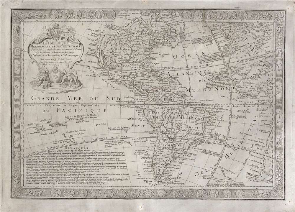

Title
L'Amérique Méridionale et Septentrionale dressée sur les Nouv.les Decouv.tes et Dernieres Relations des Meilleurs Navigateurs decetemps Conformes aux Observations Astronomiques.
1731 (dated) 19 x 27.25 in (48.26 x 69.215 cm) 1 : 31000000
1731 (dated) 19 x 27.25 in (48.26 x 69.215 cm) 1 : 31000000
Description
This is a scarce, separately-issued 1731 Guillaume Danet map of America. The map combines the cartographic innovation of Guillaume De L'Isle with the decorative flourishes of Nicholas De Fer.
A Closer Look
While drawing on the decorative tradition of mapmaking exemplified by Danet's father-in-law De Fer, the map's geographical information reflects the work of another great Parisian mapmaker, Guillaume De L'Isle. California appears as part of the mainland, the Great Lakes are illustrated and named, and the Mississippi River is depicted with its mouth in the correct location. New Orleans is labeled, which indicates that the De L'Isle map used as reference postdated 1718.A Decorative Engraving
While the geography of the map is derived from the state-of-the-art work of De L'Isle, this map does not share that mapmaker's Spartan aesthetic. The border is embellished with fleurs-de-lis in the corners. Eighteen medallions bear portraits of famous explorers. Another nine display the heraldry of French, Spanish, and Portuguese colonies. The signs of the Zodiac occupy the left and right sides. The cartouche is surmounted by the French Royal Arms, flanked by two angelic figures. At the base of the cartouche are two figures: on the left (bearing a caduceus and with bundles of goods strewn about his feet) is Mercury, the divine patron of communication and trade; to the right (with a feathered headdress and a massive club) is an avatar of America. His feet rest on a bow and arrow and an exceedingly tolerant alligator, perhaps a symbol of the friendliness of the natives.Publication History and Census
This map was engraved by Jan L'Huillier on behalf of Guillaume Danet for separate publication in 1731. The same engraver produced similar maps of the other continents for Danet, perhaps intended to be a set. The example in the Bibliothèque National de France retains a portion of text in the cartouche naming L'Huillier as the engraver. In the present example, this line has been fully excised. Between the partial erasure of the line on the BNF example and its complete erasure on ours, we suspect there to be two prior states. We are aware of two further states: one under the imprint of Desbois was printed in 1751; and a more fully amended 1766 Desnos edition. We see two examples of the 1731 2nd state only in the Bibliothèque National de France. The amended 1766 Desnos edition is similarly rare. Examples of the present map have appeared on the market from time to time over the past forty years.CartographerS
Guillaume Danet (1670 – 1732) was a Paris based French bookseller and map publisher active in the late 17th and early 18th century. Danet married Marguerite-Geneviève De Fer becoming the son-in-law of the cartographer and map publisher Nicolas De Fer (1626 – 1720). Along with his brothers and brothers-in-law, Jacques-François Bénard (Besnard) Danet (husband of Marie-Anne De Fer and engraver to the King of Spain) and Remi Richer (an engraver who sold portion of the De Fer business to his brothers in 1721), Guillaume Danet inherited a portion Nicolas De Fer's publishing business in 1720. Both Danet and Bénard used the De Fer name and signage concurrently. Danet maintained a book and map shop on the Pont Notre-Dame. After Danet's own death in 1732, the business was continued by his widow, Marguerite-Geneviève, until about 1746. Marguerite-Geneviève died in 1746 after which many of the De Fer / Danet plates were acquired by Louis Charles Desnos. More by this mapmaker...
Guillaume De l’Isle (1675 - 1726) was a French cartographer, and arguably the finest mapmaker at the beginning of the eighteenth century. He was the son of Claude De L'Isle (1644 -1720), a Paris-based historian and geographer under Nicholas Sanson, then the leading light of French cartography. He was the chief proponent of the school of 'positive geography' and the primary figure defining the heights of the Golden Age of French Cartography. Guillaume's skill as a cartographer was so prodigious that he drew his first map at just nine years of age. He was tutored by J. D. Cassini in astronomy, science, mathematics and cartography. By applying these diverse disciplines to the vast stores of information provided by 18th century navigators, Guillaume created the technique that came to be known as 'scientific cartography', essentially an extension of Sanson's 'positive geography'. This revolutionary approach transformed the field of cartography and created a more accurate picture of the world. Among Guillaume's many firsts are the first naming of Texas, the first correct map of the Mississippi, the final rejection of the insular California fallacy, and the first identification of the correct longitudes of America. Stylistically De L'Isle also initiated important changes to the medium, eschewing the flamboyant Dutch style of the previous century in favor of a highly detailed yet still decorative approach that yielded map both beautiful and informative. Guillaume was elected to the French Academie Royale des Sciences at 27. Later, in 1718, he was also appointed 'Premier Geographe du Roi', an office created especially for him. De L'Isle personally financed the publication of most of his maps, hoping to make heavy royalties on their sales. Unfortunately he met an untimely death in 1728, leaving considerable debt and an impoverished child and widow. De L'Isle's publishing firm was taken over by his assistant, Phillipe Buache, who would also become his son in law. Learn More...
Condition
Very good. Few marginal mends away from printed area; two minor irregularities in paper reinforced. Else excellent with generous margins.
References
OCLC 921739460 (earlier state).