This item has been sold, but you can get on the Waitlist to be notified if another example becomes available, or purchase a digital scan.
1606 Hondius Map of America
America-hondius-1606$2,500.00

Title
America.
1606 (undated) 15 x 20 in (38.1 x 50.8 cm) 1 : 40000000
1606 (undated) 15 x 20 in (38.1 x 50.8 cm) 1 : 40000000
Description
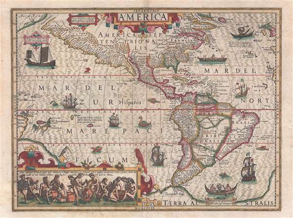
A stunning full color example of Jodocus Hondius' 1606 map of America. Presented on a stereographic projection and centered on the Americas, the map extends west to include the Pacific as far as New Guinea, and east to include the Atlantic as far as the British Isles, western Spain, and western Africa. It further extends from Greenland to the speculative continent of Terra Australis just south of the Straits of Magellan.
North America is typically distorted with a large eastward bulge in the vicinity of Virginia and the Carolinas associated with multiple erroneous calculations of longitude at sea. Sir Walter Raleigh's colony at Croatoan on the Outer Banks is noted, as is the Chesapeake Bay (Chesepiook). Newfoundland follows the Petrus Plancius model but otherwise the northeast is typical of other period maps. In what is today Maine, the apocryphal utopic American Indian city of Norumbega is noted, probably in the vicinity of Penobscot. There appears, as yet, no trace of the Great Lakes, but a note to the left of the title suggests an association of the Strait of Anian, itself an anomaly, with Davis Strait – thus hope for a northwest passage. Along the west coast evidence of Drake's voyage appears in the naming of Nova Albion, the part of the American coast Drake claimed for England.
South America exhibits considerable advancement, including a longitude correction over earlier maps of nearly 10%. Hondius identifies the lakes Parima and Eupana, as discussed below, and attempts to map the complexity of the Amazon River system. Despite postdating Drake's circumnavigation, and the evidence acquired thereby that Tierra del Fuego was in fact insular, the southernmost tip of South America is mapped as part of Terre Australis, the mythical southern continent postulated by early cosmographers.
The legend of Parima is associated with the English adventurer Sir Walter Raleigh's search for El Dorado. Believing El Dorado to lie in the northern part of the Amazon, Raleigh sailed down the Orinoco River just before the onset of the rainy season. Reaching a remote tribal village, Raleigh noted canoes arriving bearing gold, silver, and other treasures. Asked where the gold came from, the natives replied, 'Manoa', the term for the tribe to which the river traders belonged. Manoa, the natives claimed, could be reached following a long river voyage southward to a Great Lake, called Parima. Raleigh and his associates immediately associated Manoa and Lake Parima with the golden kingdom of El Dorado, though they never visited the city or lake. Subsequent maps, including this one, mapped El Dorado and Lake Parima in this location for several hundred years. Both Raleigh and the natives were describing an actual event known to occur annually in the region. Rains would annually swell the Amazon and Orinoco river systems creating a linkage in the Rupununu flood plain, which, during heavy rains, can resemble a massive lake. The Manoa were a large and populous trading nation active in pre-colonial days whose vast empire, based in the Amazon Basin, extended form the Andes to the Orinoco. Sadly, the Manoa and many of the other populous South American indigenous nations noted by the earliest explores to the region vanished, brought low by European epidemics.
Another mythical lake, Eupana, appears further south connecting the Rio de la Plata and the Paraguay River to the Amazon River and the R. Real, thus turning eastern Brazil into an island. Eupana is another term for the Laguna de Xarayes as the source of the Paraguay River. The Xarayes, a corruption of 'Xaraies' meaning 'Masters of the River,' were an indigenous people occupying what are today parts of Brazil's Matte Grosso and the Pantanal. When Spanish and Portuguese explorers first navigated up the Paraguay River, as always in search of El Dorado, they encountered the vast Pantanal flood plain at the height of its annual inundation. Understandably misinterpreting the flood plain as a gigantic inland sea, they named it after the local inhabitants, the Xaraies. The Laguna de los Xarayes almost immediately began to appear on early maps of the region and, at the same time, almost immediately took on a legendary aspect. Later missionaries and chroniclers, particularly Díaz de Guzman, imagined an island in this lake and curiously identified it as an 'Island of Paradise,'
In addition to its cartographic significance, this map is much admired for its extensive decorations and illustrative scenes, including sailing ships, fishermen, sea monsters, indigenous peoples, and more. These are generally drawn from the early volumes of Theodore de Bry's Grand Voyages. Of particular note in the scene in the lower left of Native Americans preparing an intoxicating drink made from manioc roots. This scene is from de Bry's publication of Hans Staden's harrowing captivity among the Tupinambá peoples of Brazil.
This map was engraved for the first Hondius' edition of the Gerardi Mercatoris Atlas sive Cosmographicae. The ambitions atlas was initiated by Mercator, but not completed until after his death by his sons and Hondius.
North America is typically distorted with a large eastward bulge in the vicinity of Virginia and the Carolinas associated with multiple erroneous calculations of longitude at sea. Sir Walter Raleigh's colony at Croatoan on the Outer Banks is noted, as is the Chesapeake Bay (Chesepiook). Newfoundland follows the Petrus Plancius model but otherwise the northeast is typical of other period maps. In what is today Maine, the apocryphal utopic American Indian city of Norumbega is noted, probably in the vicinity of Penobscot. There appears, as yet, no trace of the Great Lakes, but a note to the left of the title suggests an association of the Strait of Anian, itself an anomaly, with Davis Strait – thus hope for a northwest passage. Along the west coast evidence of Drake's voyage appears in the naming of Nova Albion, the part of the American coast Drake claimed for England.
South America exhibits considerable advancement, including a longitude correction over earlier maps of nearly 10%. Hondius identifies the lakes Parima and Eupana, as discussed below, and attempts to map the complexity of the Amazon River system. Despite postdating Drake's circumnavigation, and the evidence acquired thereby that Tierra del Fuego was in fact insular, the southernmost tip of South America is mapped as part of Terre Australis, the mythical southern continent postulated by early cosmographers.
The legend of Parima is associated with the English adventurer Sir Walter Raleigh's search for El Dorado. Believing El Dorado to lie in the northern part of the Amazon, Raleigh sailed down the Orinoco River just before the onset of the rainy season. Reaching a remote tribal village, Raleigh noted canoes arriving bearing gold, silver, and other treasures. Asked where the gold came from, the natives replied, 'Manoa', the term for the tribe to which the river traders belonged. Manoa, the natives claimed, could be reached following a long river voyage southward to a Great Lake, called Parima. Raleigh and his associates immediately associated Manoa and Lake Parima with the golden kingdom of El Dorado, though they never visited the city or lake. Subsequent maps, including this one, mapped El Dorado and Lake Parima in this location for several hundred years. Both Raleigh and the natives were describing an actual event known to occur annually in the region. Rains would annually swell the Amazon and Orinoco river systems creating a linkage in the Rupununu flood plain, which, during heavy rains, can resemble a massive lake. The Manoa were a large and populous trading nation active in pre-colonial days whose vast empire, based in the Amazon Basin, extended form the Andes to the Orinoco. Sadly, the Manoa and many of the other populous South American indigenous nations noted by the earliest explores to the region vanished, brought low by European epidemics.
Another mythical lake, Eupana, appears further south connecting the Rio de la Plata and the Paraguay River to the Amazon River and the R. Real, thus turning eastern Brazil into an island. Eupana is another term for the Laguna de Xarayes as the source of the Paraguay River. The Xarayes, a corruption of 'Xaraies' meaning 'Masters of the River,' were an indigenous people occupying what are today parts of Brazil's Matte Grosso and the Pantanal. When Spanish and Portuguese explorers first navigated up the Paraguay River, as always in search of El Dorado, they encountered the vast Pantanal flood plain at the height of its annual inundation. Understandably misinterpreting the flood plain as a gigantic inland sea, they named it after the local inhabitants, the Xaraies. The Laguna de los Xarayes almost immediately began to appear on early maps of the region and, at the same time, almost immediately took on a legendary aspect. Later missionaries and chroniclers, particularly Díaz de Guzman, imagined an island in this lake and curiously identified it as an 'Island of Paradise,'
...an island [of the Paraguay River] more than ten leagues [56 km] long, two or three [11-16 km] wide. A very mild land rich in a thousand types of wild fruit, among them grapes, pears and olives: the Indians created plantations throughout, and throughout the year sow and reap with no difference in winter or summer, ... the Indians of that island are of good will and are friends to the Spaniards; Orejon they call them, and they have their ears pierced with wheels of wood ... which occupy the entire hole. They live in round houses, not as a village, but each apart though keep up with each other in much peace and friendship. They called of old this island Land of Paradise for its abundance and wonderful qualities.To the north of the 'Island of Paradise' appeared the 'Puerto de los Reyes' which was considered to be a gateway to the Amazon and the Kingdom of el Dorado.
In addition to its cartographic significance, this map is much admired for its extensive decorations and illustrative scenes, including sailing ships, fishermen, sea monsters, indigenous peoples, and more. These are generally drawn from the early volumes of Theodore de Bry's Grand Voyages. Of particular note in the scene in the lower left of Native Americans preparing an intoxicating drink made from manioc roots. This scene is from de Bry's publication of Hans Staden's harrowing captivity among the Tupinambá peoples of Brazil.
This map was engraved for the first Hondius' edition of the Gerardi Mercatoris Atlas sive Cosmographicae. The ambitions atlas was initiated by Mercator, but not completed until after his death by his sons and Hondius.
Cartographer
Jodocus Hondius (October, 14 1563 - February 12, 1612) was an important Dutch cartographer active in the late 16th and early 17th centuries. His common name, Jodocus Hondius is actually a Latinized version of his Dutch name, Joost de Hondt. He is also sometimes referred to as Jodocus Hondius the Elder to distinguish him from his sons. Hondius was a Flemish artist, engraver, and cartographer. He is best known for his early maps of the New World and Europe, for re-establishing the reputation of the work of Gerard Mercator, and for his portraits of Francis Drake. Hondius was born and raised in Ghent. In his early years he established himself as an engraver, instrument maker and globe maker. In 1584 he moved to London to escape religious difficulties in Flanders. During his stay in England, Hondius was instrumental in publicizing the work of Francis Drake, who had made a circumnavigation of the world in the late 1570s. In particular, in 1589 Hondius produced a now famous map of the cove of New Albion, where Drake briefly established a settlement on the west coast of North America. Hondius' map was based on journal and eyewitness accounts of the trip and has long fueled speculation about the precise location of Drake's landing, which has not yet been firmly established by historians. Hondius is also thought to be the artist of several well-known portraits of Drake that are now in the National Portrait Gallery in London. In 1593, Hondius returned to Amsterdam, where he remained until the end of his life. In 1604, he purchased the plates of Gerard Mercator's Atlas from Mercator's grandson. Mercator's work had languished in comparison to the rival atlas, Theatrum Orbis Terrarum by Ortelius. Hondius republished Mercator's work with 36 additional maps, including several which he himself produced. Despite the addition of his own contributions, Hondius recognizing the prestige of Mercator's name, gave Mercator full credit as the author of the work, listing himself as the publisher. Hondius' new edition of Mercator revived the great cartographer's reputation and was a great success, selling out after a year. Hondius later published a second edition, as well as a pocket version called the Atlas Minor. The maps have since become known as the "Mercator/Hondius series". Between 1605 and 1610 Hondius was employed by John Speed to engrave the plates for Speed's The Theatre of the Empire of Great Britaine. Following Hondius' death in 1612, his publishing work in Amsterdam was continued by his widow and two sons, Jodocus II and Henricus. Later his family formed a partnership with Jan Jansson, whose name appears on the Atlasas co-publisher after 1633. Eventually, starting with the first 1606 edition in Latin, about 50 editions of the Atlas were released in the main European languages. In the Islamic world, the atlas was partially translated by the Turkish scholar Katip Çelebi. The series is sometimes called the 'Mercator/Hondius/Jansson' series because of Jansson's later contributions. Hondius' is also credited with a number of important cartographic innovations including the introduction of decorative map borders and contributions to the evolution of 17th century Dutch wall maps. The work of Hondius was essential to the establishment Amsterdam as the center of cartography in Europe in the 17th century. More by this mapmaker...
Condition
Very good. Minor wear on original centerfold. Blank on verso.
References
Burden, P., The Mapping of North America, #150. Van der Krogt 1, 9000:1B. Wagner, H. R., The Cartography of the Northwest Coast of America to the Year 1800, 245. Portinaro, P., and Knirsch, F., The Cartography of North America 1500-1800, LXXIII.