
This item below is out of stock, but another example (left) is available. To view the available item, click "Details."
Details
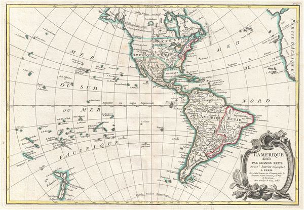
1762 Janvier Map of North America and South America (Sea of the West)
1762 (dated) $750.00
1783 Janvier Map of North America and South America
America-lattre-1783$250.00

Title
L'Amerique divisee Par Grands Etats.
1783 (dated) 12.5 x 18 in (31.75 x 45.72 cm) 1 : 60000000
1783 (dated) 12.5 x 18 in (31.75 x 45.72 cm) 1 : 60000000
Description
An altogether fascinating map of North America and South America by Jean Janvier dating to 1883. Covers both continents from the Antarctic Circle to the Arctic Circle, extends westward to New Zealand and eastward as far as Africa and Spain. The 'Sea of the West,' speculated by Philippe Buache and Guillaume De l'Isle in the early 18th century, has here been eliminated. Instead, the discoveries of Cook, both in Hawaii and in the Pacific Northwest are beginning to emerge - with Alaska being vaguely recognizable.
On the opposite side of the map, Janvier places the Great Lakes firmly within French territory, a clear case of carto-advocacy. He also extends Spanish control of the eastern coast of North America well north of the traditional Florida boundary to including Georgia and parts of Carolina.
South America is typically well mapped along the coastlines and relatively speculative throughout the interior. Janvier drops the popular myth of Lake Parima and El Dorado in Guyana, but maintains the Lac Xarayes as the northern terminus of the Paraguay River. The Xaraies, meaning 'Masters of the River' were an indigenous people occupying what are today parts of Brazil's Matte Grosso and the Pantanal. When Spanish and Portuguese explorers first navigated up the Paraguay River, as always in search of el Dorado, they encountered the vast Pantanal flood plain at the height of its annual inundation. Understandably misinterpreting the flood plain as a gigantic inland sea, they named it after the local inhabitants, the Xaraies. The Laguna de los Xarayes almost immediately began to appear on early maps of the region and, at the same time, almost immediately took on a legendary aspect as the gateway to el Dorado.
Polynesia is mapped with numerous islands named, but few are the correct size or in the correct place. Hawaii, which has just been discovered by Cook, is noted for the first time. 'Terre vue par Davis' is identified roughly where easter Island is today. Terre de Davis or Davis' Land was supposedly discovered in 1688 by an English navigator of the same name. Many historians argue whether or not Davis Land was actually eastern Island, but it does seem likely. New Zealand has been updated from earlier editions to reflect Cook's explorations in the region and is presented in two island form.
The lower right hand quadrant is dominated by a decorative title cartouche depicting some of the flora of the continents.
Drawn by Jean Janvier in 1783 for issue as plate no. 31 in Jean Lattre's 1783 issue of the Atlas Moderne.
CartographerS
Jean Denis Janvier (fl. 1746 - 1776), sometime also known as 'Robert', was a Paris based cartographer active in the mid to late 18th century. Janvier signed his maps Signor Janvier. By the late 18th century, Janvier was awarded the title of 'Geographe Avec Privilege du Roi' and this designation appears on many of his later maps. Janvier worked with many of the most prominent French, English and Italian map publishers of his day, including Longchamps, Faden, Lattre, Bonne, Santini, Zannoni, Delamarche, and Desnos. More by this mapmaker...
Jean Lattré (170x - 178x) was a Paris based bookseller, engraver, globe maker, calligrapher, and map publisher active in the mid to late 18th century. Lattré published a large corpus of maps, globes, and atlases in conjunction with a number of other important French cartographic figures, including Janvier, Zannoni, Bonne and Delamarche. He is also known to have worked with other European cartographers such as William Faden of London and the Italian cartographer Santini. Map piracy and copyright violations were common in 18th century France. Paris court records indicate that Lattré brought charges against several other period map publishers, including fellow Frenchman Desnos and the Italian map engraver Zannoni, both of whom he accused of copying his work. Lattré likes trained his wife Madame Lattré (né Vérard), as an engraver, as a late 18th century trade card promotes the world of 'Lattré et son Epouse.' Lattré's offices and bookshop were located at 20 rue St. Jaques, Paris, France. Later in life he relocated to Bordeaux. Learn More...
Source
Lattre, Jean, Atlas Moderne ou Collection de Cartes sur Toutes les Parties du Globe Terrestre, c. 1783.
Condition
Very good condition. Original centerfold. Blank on verso.
References
Rumsey 2612.069. Phillips (Atlases) 629-32. New York Public Library, Map Division, 96-7687.