This item has been sold, but you can get on the Waitlist to be notified if another example becomes available, or purchase a digital scan.
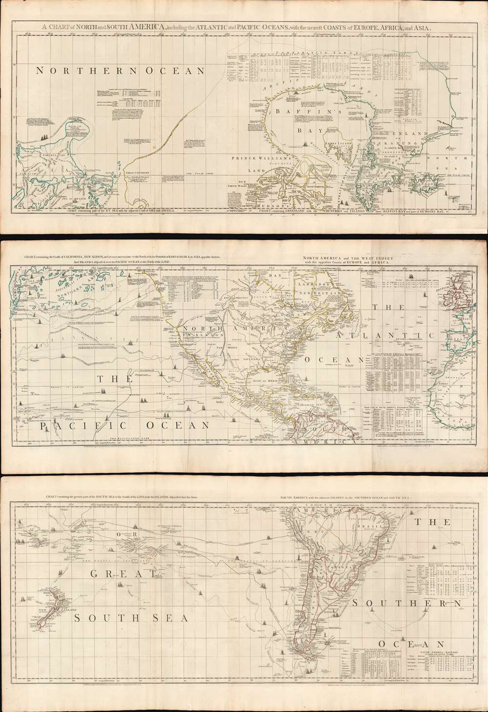
1775 Sayer and Bennet / Braddock Mead 3-Part Map of America
America-sayerbennett-1775$4,750.00

Title
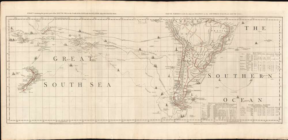
A Chart of North and South America, including the Atlantic and Pacific Oceans, with the nearest Coasts of Europe, Africa, and Asia.
1775 (dated) 66 x 45 in (167.64 x 114.3 cm) 1 : 21000000
1775 (dated) 66 x 45 in (167.64 x 114.3 cm) 1 : 21000000
Description
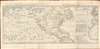
A wonderful 1775 map of the Americas or Western Hemisphere by John Green, also known as Braddock Mead. The map in fact consists of three related maps covering, from top: Canada and the Arctic; the modern day United States, Central America, and the West Indies; and South America. The map is a masterpiece of late 18th century cartography by one of the least understood and most controversial cartographers of his age. Mead composed the map in protest to what he believed to be the flagrantly spurious and irresponsible speculative cartography of Frenchmen Joseph-Nicolas De l'Isle (1688 - 1768) and Phillipe Buache (1700 - 1773).
When Captain James Cook visited this region a few years later, in 1778, he had Staehlin's map in hand. Based upon Staehlin's cartography, Cook surmised that he should be able to sail around 'Alaschka' thus making his way northward into the fabled Northwest Passage. He initially believed that he may have found such a passage at Cook Inlet, but did not explore further. Still, Cook we intensely disappointed by Staehlin's geography, of which he wrote
A Forthright Cartographer
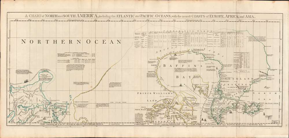
The cartographer, Braddock Mead / John Green, is uncommonly forthright with his process and, through his many annotations, we can to some extant begin to understand his reasoning as he attempts to piece together a mostly unexplored land. We imagine him leaning over a desk strewn with conflicting maps prepared by his contemporaries. We imagine him drawing tables of latitudinal and longitudinal points drawn from the records of known navigators and comparing them with those of other cartographers - much as appears in the 'Comparative Table' at top center. Here, Mead offers his own latitudes and longitudes and compares them with those of Bellin, and D'Anville, thus arguing for the superiority of his own research. Throughout he references explorations and discoveries, often offering commentary and delineating the route of notable navigators including Baffin, Hudson, Vitus Bering, and othersUpper Chart
Focusing on Alaska (Bering Strait) and the Canadian Arctic, the map covers from the Sea of Okhotsk (Penschinaska Guba) to Iceland and the east coast of Greenland from about 85 degrees north latitude to the southern shores of Greenland and Hudson Bay.The Speculative Pacific Northwest
This map's most compelling cartography appears in the Pacific Northwest. Here Mead is attempting to reconcile the discoveries of Vitus Bering with earlier cartographic speculations and recently 'rediscovered' Japanese cartography. Mead draws heavily on maps published one year earlier by Jakob von Staehlin. It was Staehlin, working in 1774 from the records of Bering, Gvozdef, and Fedorov (among others) archived in the repository of Royal Academy of Sciences at St. Petersburg, who first drew the Peninsula of Tchuktschi and defined an island named Alaschka. Technically, from the Russian perspective, Alaska (Alaschka), which was derived from the Aleut 'alaxsxaq' meant 'object toward which the action of the sea is directed,' 'great continent' or, quite basically, 'the mainland.' The notion that it might have been an island seems to extend from reports by Russian traders and military officers. Specifically, in 1768, Krenitsyn and Levashev, Russian naval officers, wrote of a large island called 'Alaxa' northeast of Unimak Island referenced by Alaskan natives as the 'Island of Alaschka.' Staehlin applied these reports to reconcile anomalies on the Japanese map acquired by the German naturalist, physician, and orientalist Engelbert Kaempfer - as Mead suggests here. This Japanese map shows an unnamed island in the vicinity of Alaska, which Staehlin expands in size and reorients to correspond to lands discovered by Gvozdef in the wake of the Bering-Chirikov expedition. The other islands, some of which are named, and some of which are not, are derived from the reports of Captain Ivan Sindt (Sindo). Sindt sailed with Bering and later, in 1768, led his own expedition to the region. As some have suggested he seems to have greatly exaggerated both the size and quantity of the islands he encountered. Staehlin used this to fill in the blanks between the Kaempfer Japanese map and the Bering maps.When Captain James Cook visited this region a few years later, in 1778, he had Staehlin's map in hand. Based upon Staehlin's cartography, Cook surmised that he should be able to sail around 'Alaschka' thus making his way northward into the fabled Northwest Passage. He initially believed that he may have found such a passage at Cook Inlet, but did not explore further. Still, Cook we intensely disappointed by Staehlin's geography, of which he wrote
What could induce him to publish so erroneous a Map in which many of these islands are jumbled in regular confusion without the least regard to the truth, and yet he is pleased to call it a very accurate little map? A map that the most illiterate of his illiterate Sea-faring men would have been ashamed to put his name to.
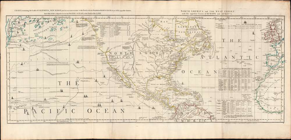
The Middle Map
The central map, covering from Hudson Bay to the northern part of South America, inclusive of the modern-day United States, Canada, Mexico, and Central America, was then, as now, the centerpiece of the set. The map offers a wealth of commentary concerning known and unknown aspects of this land, particularly in the TransMississippi. It notes but gives no credence to the spurious discoveries of Admiral de Fonte, as well as the more factual discoveries of Francis Drake, Juan de Fuca, and Martin D'Aguilar. It notes the River of the West and the presumed Chinese colony of Fusang. An expansive River of the West (the Columbia River?) stretches from the American Coast inland to Lake Winnipeg.Fusang
Along the coast of modern-day British Columbia, in an unexplored zone identified by ghosted lines, the postulated Chinese colony of Fusang is identified. Fusang or Fousang is a region first documented by the Chinese Buddhist missionary Hui Shen in the 5th century. Hui Shen describes a land some 20,000 Chinese Li (c. 8000 km) east of the China coast. Fusang is described in considerable detail in the 7th century Book of Liang by Yao Silian. There are also accounts that the land was settled c. 220 BC by a Chinese Emperor of the Han Dynasty. In later days Fusang was commonly used in Chinese poetry to designate Japan, however earlier references keep it distinct. In any case, Hui Shen's description of Fusang with regard to distance and geography corresponds more with the coastlands of North America than with Japan. The French historian Joseph de Guignes in his 1761 article Le Fou-Sang des Chinois est-il l'Amerique? promoted this idea. Cartographers of the era, including Buache de Neuville, Zatta, Robert de Vaugondy, and others, embraced the idea and it was included in many subsequent maps of the region.De Fonte
The tale of De Fonte' discoveries in the American Northwest had an enduring influence on cartographic representations of America through the second half of the 18th century and even into the early parts of the 19th century. The De Fonte legend first appeared in a 1706 English publication entitled Memoirs of the Curious. This short-lived magazine published a previously unknown account by a supposed Spanish Admiral named Bartholomew de Fonte. De Fonte is said to have sailed up the Pacific Coast of North America in 1640. On this voyage, he is said to have discovered a series of gigantic lakes, seas, and rivers heading eastward from the Pacific towards Hudson Bay. The De Fonte story relates how, on one of these inland lakes, he met with a westward bound ship from Boston that could only have come through a Northwest Passage. At the same time, De Fonte sent one of his sub-captains, Pedro Bernarda, northward to explore a 'beautiful river with deep calm waters.' This sub-exploration led to the discoveries of Lake Valasco, R. Bernarda, and Lac Bernarda - as seen here. Today, based upon inaccuracies and falsities, most believe the entire De Fonte legend to have been a fabrication. Nonetheless, it set 18th century Europe afire with speculation. Even such luminaries as Benjamin Franklin wrote long defenses of De Fonte.The South America Sheet
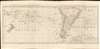
The southernmost sheet of the vertical triptych embraces the bulk of South America from the Amazon River to Tierra de Fuego and beyond, extending west to include New Zealand, and east as far as St. Helena. Although coastal South America was populous, the interior at the time remained largely a mystery. The cartographer nonetheless includes the Laguna de Xarayes, mythical gateway to El Dorado, at the northern terminus of the Paraguay River. In the surrounding seas, considerable attention is given to exploratory routes, including those of Bourgainville, Cook, Carteret, Byron, Narboro, and Wallis.Laguna de Xarayes
The mythical Laguna de Xarayes is illustrated here as the northern terminus, or source, of the Paraguay River. The Xarayes, a corruption of 'Xaraies' meaning 'Masters of the River', were an indigenous people occupying what are today parts of Brazil's Matte Grosso and the Pantanal. When Spanish and Portuguese explorers first navigated up the Paraguay River, as always in search of El Dorado, they encountered the vast Pantanal flood plain at the height of its annual inundation. Understandably misinterpreting the flood plain as a gigantic inland sea, they named it after the local inhabitants, the Xaraies. The Laguna de los Xarayes almost immediately began to appear on early maps of the region and, at the same time, to take on a legendary quality. Later missionaries and chroniclers, particularly Díaz de Guzman, imagined an island in this lake and curiously identified it as 'Island of Paradise,'...an island [of the Paraguay River] more than ten leagues [56 km] long, two or three [11-16 km] wide. A very mild land rich in a thousand types of wild fruit, among them grapes, pears and olives: the Indians created plantations throughout, and throughout the year sow and reap with no difference in winter or summer, ... the Indians of that island are of good will and are friends to the Spaniards; Orejón they call them, and they have their ears pierced with wheels of wood ... which occupy the entire hole. They live in round houses, not as a village, but each apart though keep up with each other in much peace and friendship. They called of old this island Land of Paradise for its abundance and wonderful qualities.
Publication History and Census
This map was drawn by Braddock Mead for Thomas Jefferys, but here published by Sayer and Bennett for publication in the 1776 edition of their iconic American Atlas. Well represented institutionally but scarce to the market - especially in this outstanding condition.CartographerS
Robert Sayer (1725 - January 29, 1794) was an important English map publisher and engraver active from the mid to late 18th century. Sayer was born in Sunderland, England, in 1725. He may have clerked as a young man with the Bank of England, but this is unclear. His brother, James Sayer, married Mary Overton, daughter-in-law of John Overton and widow of Philip Overton. Sayer initially worked under Mary Overton, but by December of 1748 was managing the Overton enterprise and gradually took it over, transitioning the plates to his own name. When Thomas Jefferys went bankrupt in 1766, Sayer offered financial assistance to help him stay in business and, in this way, acquired rights to many of the important Jefferys map plates as well as his unpublished research. From about 1774, he began publishing with his apprentice, John Bennett (fl. 1770 - 1784), as Sayer and Bennett, but the partnership was not formalized until 1777. Bennett retired in 1784 following a mental collapse and the imprint reverted to Robert Sayer. From 1790, Sayer added Robert Laurie and James Whittle to his enterprise, renaming the firm Robert Sayer and Company. Ultimately, Laurie and Whittle partnered to take over his firm. Sayer retired to Bath, where, after a long illness, he died. During most of his career, Sayer was based at 53 Fleet Street, London. His work is particularly significant for its publication of many British maps relating to the American Revolutionary War. Unlike many map makers of his generation, Sayer was a good businessman and left a personal fortune and great estate to his son, James Sayer, who never worked in the publishing business. More by this mapmaker...
Braddock Mead (c. 1688 - 1757), also known as John Green, was an Irish cartographer and map engraver active in London during the middle part of the 18th century. Mead is one of the most interesting and colorful figures in cartography whose louche personal life sharply contrasted with the high standard of his maps. Mead was born in Ireland around 1688 and seems to have come from a good family and received a respectable education. His brother Thomas Mead held the position of Lord Mayor of Dublin in 1757. Braddock Mead left Dublin for London around 1717 where he plunged into vice, subsidizing his cartographic work with hack work and gambling. In 1728 Mead fell in with a plot to defraud a 12 year old Irish heiress, Bridget Reading, of her fortune by kidnapping and marrying her himself. Mead suffered jail time for the crime but was more fortunate than his partner, a fellow Irishman named Kimberly, who was hanged. As a cartographer Mead cannot have exhibited a more antithetical character. He held himself and others to the highest standards of accuracy and scholarship, and issued a call for greater transparency in the field of mapmaking. Mead worked with Ephraim Chambers on the Universal Dictionary, as well as with Cave and Astley in the publication of various travelogues and explorer's journals, notably Astley’s New General Collection of voyages and travels. Eventually he came to work for the publishing house of Thomas Jefferys, who saw through Mead's personal failings to appreciate his cartographic brilliance. Mead has been called the genius behind Jefferys and he seems to have had a hand in the production of many of Jefferys' most important maps. William Cumming notes that Mead
had a number of marked characteristics as a cartographer ... One was his ability to collect, to analyze the value of, and to use a wide variety of sources; these he acknowledged scrupulously on the maps he designed and even more fully in accompanying remarks. Another outstanding characteristic was his intelligent compilation and careful evaluation of reports on latitudes and longitudes used in the construction of his maps, which he also entered in tables on the face of the maps ... Mead's contributions to cartography stand out ... At a time when the quality and the ethics of map production were at a low ebb in England, he vigorously urged and practiced the highest standards; in the making of maps and navigational charts he was in advance of his time. For this he deserves due credit.Learn More...
Source
Sayer, R., Bennett, J., and Jefferys, T., The American Atlas: Or, A Geographical Description Of The Whole Continent Of America ... Engraved On Forty-Eight Copper Plates, By The Late Mr. Thomas Jefferys, Geographer to the King, and Others, (London: Sayer and Bennett) 1776.
Thomas Jefferys' The American Atlas is among the most important atlases of American issued during and after the American Revolutionary War (1775 - 1783). Burden calls it 'arguably the first American 'state' atlas' and Ristow writes, it is a '… major cartographic reference work it was very likely consulted by American, English and French civilian administrators and military officers during the Revolution…' It was first published in 1775, with updates following in 1776, 1778, 1782, 1794, and 1800. All editions are notably postdate Jefferys himself, who died in 1771. The application of his name to the The American Atlas is mostly an honorific - though most of the constituent maps can be traced to Jefferys' work. After Jefferys' death, his map plates were acquired by his partner, printseller Robert Sayer. By the mid-1770s Sayer had taken on John Bennett as a partner. Together, they compiled and updated many of Jefferys' map, published as the to capitalize on interest in America associated with the Revolution. Maps from the The American Atlas exhbit is considerable date variation, with some featuring dates later than the title page, suggesting that many were updated by owners in subsequent years, and/or that the title page was reused for latter editions.
Condition
Very good. Minor wear and toning on old fold lines. Dimensions reflect full size of three sheets with margins together, as shown in primary image.
References
Rumsey 0346.001. Tooley, R. V., The Mapping of America, (Stevens and Tree), 4(d). Wagner, H. R., The Cartography of the Northwest Coast of America To the Year 1800, 649.