This item has been sold, but you can get on the Waitlist to be notified if another example becomes available, or purchase a digital scan.
1635 / 1642 Willem Blaeu Map of America: A Superb Example
Americae-blaeu-1635-3$4,500.00

Title
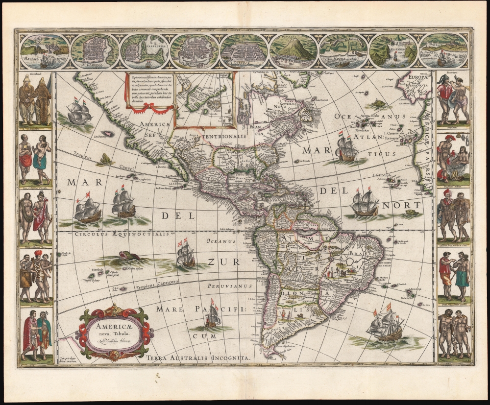
Americae Nova Tabula. Auct. Guilielmo Blaeuw.
1635 (undated) 16.5 x 22 in (41.91 x 55.88 cm) 1 : 44000000
1635 (undated) 16.5 x 22 in (41.91 x 55.88 cm) 1 : 44000000
Description
The essential Dutch map of America: Willem Janszoon Blaeu's 1635 carte-á-figures of the Western Hemisphere. This is among the most desirable printed maps, encapsulating in one piece the most sought-after aesthetic qualities of the Dutch Golden Age of Cartography.
A Beautifully Figured Map
Blaeu's Americae is a premier example of the carte-á-figures, or 'figured map,' displaying in its upper border the most important cities in the seventeenth-century Americas, and in its left and right borders finely-engraved depictions of the new world's native peoples. The cities thus depicted are (from left) Havana, Santo Domingo, Cartagena, Mexico, Cusco, Potosi, La Mocha, Rio de Janeiro, and Olinda. The denizens of the Americas here depicted include Greenlanders, Virginians, Floridians, Californians (specifically, the King and Queen of Nova Albion) Mexicans, Peruvians, Brazilians, Chileans, and the natives of Magellanica (these last, possibly intended to be the giants reported by the survivors of Magellan's voyage). The decorative elements of the map are not limited to the borders: the seas are sailed by no fewer than eight ships sporting Dutch flags, an expression of control of the seas surrounding the new continent.Censored Cartography
Apart from his world map, this is the only Blaeu folio map to show all of North America. Consequently, it had a long printing life. When Blaeu first produced the map in 1617, it not only bore the mapmaker's proper name - Guiljel: Janssonio - but also showed fewer islands in the Pacific and presented a more primitive depiction of the Strait of Magellan. The present map improved on these areas to reflect the findings of Le Maire and Schouten's 1615-1617 circumnavigation, news of which Blaeu was aware but was prevented, by the Dutch East India Company's censorship, from printing in 1617. (Blaeu's protest that his competitors were already printing the new data led the Company to relent, and he printed the corrected version of his map in 1618.) From that point forward, the plate remained in use with minor aesthetic changes, none of which represent changes in geographical knowledge.Scope and Features of the Map
The engraving covers all of North and South America and the surrounding seas, extending eastward to Europe and Africa, and westward to the unexplored central Pacific. At the southernmost point of South America, Tierra del Fuego is shown as an island separate from the hypothetical Terra Australis Incognita, including both the Strait of Magellan and the Strait of Le Maire. The northernmost regions shown in the main map are Hudson's Bay, the coasts around the Davis Strait and part of Nicolo Zeno's phantom island of Frisland. An inset map shows the coastline of Greenland in more completeness, a complete rendering of Frisland (along with the Greenland coast, also derived from Zeno's fraudulent geography), and an accurate depiction of Iceland. The mapping of North America reveals little knowledge beyond the coastline. The Saint Lawrence River appears to take its beginning in an array of small lakes, but no recognizable Great Lakes are shown. The Mississippi does not yet appear, although there are several rivers emptying into the Gulf of Mexico, their watershed bounded by imaginary mountain ranges. In the North American southwest a proto-Colorado River appears with its start in a lake surrounded by the legendary Seven Cities of Gold. The Pacific Coast shows no sign of an insular California (while that canard had begun to appear on other maps as early as 1624, Blaeu's map was never updated to include it).East Coast of America
The east coast of North America includes a rudimentary depiction of the 1591 John White cartography, appearing as an outsized and protuberant Virginia and Outer Banks. The Canadian Maritimes appear recognizably, but between Virginia and Nova Scotia the geography becomes imaginary. The highlight of the American northeast is the appearance of Norembega, a kind of northeastern El Dorado (El Dorado itself appears in South America). Norembega or Nurembega appears in what is today New England. This mysterious land began being mapped with Verrazano's 1529 manuscript chart of America. He used the term 'Oranbega' which in Algonquin means something on the order of 'lull in the river'. References to this place, spelled on variations of Nurumbeg, Norumbega and so on, began to appear in travelers' journals, collecting wilder descriptions until it was reputed to be a fabulous city rich in pearls and built upon pillars of crystal, silver, and gold. The idea caught on in the European popular imagination and expeditions were sent to search for the city - including that of Samuel de Champlain. Thereafter variants of the place would continue appearing on maps, reflecting a reluctance to erase so tempting a destination.El Dorado
Similarly, in South America Blaeu includes El Dorado (Manoa al Dorada) on the shores of a large, imaginary lake in what is today Northern Brazil or southern Guyana reflecting the European belief that the legendary city was the equally mythical city of Manoa, first reported by Sir Walter Raleigh in 1595 and placed on the shores of the Lake Parima. Raleigh did not claim to have visited the city but described the city based on indigenous accounts. Parts of the Amazon were, at the time, dominated by a large and powerful Indigenous trading nation known as the Manoa, and rainy seasons occasionally connected the Amazon and Orinoco River systems, affording the Manoans the ability to trade with the Incans in the western Amazon, providing access to gold mines on the western slopes of the Andes. So Raleigh's suppositions may have had some basis in fact.Publication History and Census
As mentioned above, this map was initially engraved in 1617. It was published separately until it was included in Blaeu's 1630 Appendix, consequently the 1617 first and 1618 second states of the map are exceedingly rare. The 1621 third state was included in Blaeu atlases until 1642, when the engraving was retouched, resulting in this present fourth state, mainly distinguishable from earlier versions by additional engraving of waves appearing in the area between 240 and 250 degrees longitude and 10 and 20 degrees latitude south. There are a total of five states and records of reissues from 1617 to 1663. The typography of the present example, combined with its state identifies it as belonging to a 1642 Dutch edition of Joan Blaeu's Niewe Atlas (Fourth state, page 1, catch letters West-Indien A). The Blaeu firm was destroyed by fire in 1672 and no subsequent editions were produced. States four and five of the map appear on the market, with a premium associated with beautiful original hand color and strong condition, both of which are in evidence in this superb example.CartographerS
Willem Janszoon Blaeu (1571 - October 18, 1638), also known as Guillaume Blaeu and Guiljelmus Janssonius Caesius, was a Dutch cartographer, globemaker, and astronomer active in Amsterdam during the late 16th and early 17th centuries. Blaeu was born 'Willem Janszoon' in Alkmaar, North Holland to a prosperous herring packing and trading family of Dutch Reformist faith. As a young man, he was sent to Amsterdam to apprentice in the family business, but he found the herring trade dull and instead worked for his cousin 'Hooft' as a carpenter and clerk. In 1595, he traveled to the small Swedish island of Hven to study astronomy under the Danish Enlightenment polymath Tycho Brahe. For six months he studied astronomy, cartography, instrument making, globe making, and geodesy. He returned to Alkmaar in 1596 to marry and for the birth of his first son, Johannes (Joan) Blaeu (1596 – 1673). Shortly thereafter, in 1598 or 1599, he relocated his family to Amsterdam where he founded the a firm as globe and instrument makers. Many of his earliest imprints, from roughly form 1599 - 1633, bear the imprint 'Guiljelmus Janssonius Caesius' or simply 'G: Jansonius'. In 1613, Johannes Janssonius, also a mapmaker, married Elizabeth Hondius, the daughter of Willem's primary competitor Jodocus Hondius the Elder, and moved to the same neighborhood. This led to considerable confusion and may have spurred Willam Janszoon to adopt the 'Blaeu' patronym. All maps after 1633 bear the Guiljelmus Blaeu imprint. Around this time, he also began issuing separate issue nautical charts and wall maps – which as we see from Vermeer's paintings were popular with Dutch merchants as decorative items – and invented the Dutch Printing Press. As a non-Calvinist Blaeu was a persona non grata to the ruling elite and so he partnered with Hessel Gerritsz to develop his business. In 1619, Blaeu arranged for Gerritsz to be appointed official cartographer to the VOC, an extremely lucrative position that that, in the slightly more liberal environment of the 1630s, he managed to see passed to his eldest son, Johannes. In 1633, he was also appointed official cartographer of the Dutch Republic. Blaeu's most significant work is his 1635 publication of the Theatrum orbis terrarum, sive, Atlas Novus, one of the greatest atlases of all time. He died three years later, in 1638, passing the Blaeu firm on to his two sons, Cornelius (1616 - 1648) and Johannes Blaeu (September 23, 1596 - December 21, 1673). Under his sons, the firm continued to prosper until the 1672 Great Fire of Amsterdam destroyed their offices and most of their printing plates. Willem's most enduring legacy was most likely the VOC contract, which ultimately passed to Johannes' son, Johannes II, who held the position until 1617. As a hobbyist astronomer, Blaeu discovered the star now known as P. Cygni. More by this mapmaker...
Joan (Johannes) Blaeu (September 23, 1596 - December 21, 1673) was a Dutch cartographer active in the 17th century. Joan was the son of Willem Janszoon Blaeu, founder of the Blaeu firm. Like his father Willem, Johannes was born in Alkmaar, North Holland. He studied Law, attaining a doctorate, before moving to Amsterdam to join the family mapmaking business. In 1633, Willem arranged for Johannes to take over Hessel Gerritsz's position as the official chartmaker of the Dutch East India Company, although little is known of his work for that organization, which was by contract and oath secretive. What is known is his work supplying the fabulously wealthy VOC with charts was exceedingly profitable. Where other cartographers often fell into financial ruin, the Blaeu firm thrived. It was most likely those profits that allowed the firm to publish the Theatrum Orbis Terrarum, sive, Atlas Novus, their most significant and best-known publication. When Willem Blaeu died in 1638, Johannes, along with his brother Cornelius Blaeu (1616 - 1648) took over the management of the Blaeu firm. In 1662, Joan and Cornelius produced a vastly expanded and updated work, the Atlas Maior, whose handful of editions ranged from 9 to an astonishing 12 volumes. Under the brothers' capable management, the firm continued to prosper until the 1672 Great Amsterdam Fire destroyed their offices and most of their printing plates. Johannes Blaeu, witnessing the destruction of his life's work, died in despondence the following year. He is buried in the Dutch Reformist cemetery of Westerkerk. Johannes Blaeu was survived by his son, also Johannes but commonly called Joan II, who inherited the family's VOC contract, for whom he compiled maps until 1712. Learn More...
Source
Blaeu, W. / Blaeu, J., Niewe Atlas, (Amsterdam: Blaeu) 1642.
The classic Dutch atlas, whose publication ushered in the Dutch golden age of cartography. Willem Jansz Blaeu had been, since 1604, producing engraved maps for sale; these were separate issues (and all consequently extremely rare) until the publishing of Blaeu's Appendix in 1630 and 1631, which also included a number of maps purchased from the widow of Jodocus Hondius, (for example his famous iteration of John Smith's map of Virginia.) In 1634, he announced his intention to produce a new world atlas in two volumes, entitled Theatrum Orbis Terrarum, sive Atlas Novus (Théâtre du Monde ou Nouvel Atlas) (in an effort to invoke the successful work of the same title produced by Ortelius the previous century, while reinforcing the notion of it being a new work.) This work was published first in German in 1634, followed by Latin, Dutch and French editions in 1635. Blaeu's maps have always been noted for the quality of their paper, engraving and fine coloring, and this was the intent from the very start. The 1634 announcement of the upcoming work described it: 'All editions on very fine paper, completely renewed with newly engraved copperplates and new, comprehensive descriptions.' (van der Krogt, p,43) Many of the most beautiful and desirable maps available to the modern collector were printed and bound in Blaeu's atlases. Willem's son, Joan, would go on to add further volumes to the Atlas Novus, concurrently printing new editions of the first two volumes with additional maps, in effect making these new editions an entirely new book. Under Joan there would be nine Latin editions, twelve French, at least seven Dutch, and two German. This exceedingly successful work would be the mainstay of the Blaeu firm until 1661, at which point the work was supplanted by Joan Blaeu's masterwork Atlas Maior in 1662.
Condition
Excellent. Marginal toning at centerfold outside printed image, else a fine example with superb original color.
References
OCLC 158753075. Burden, P., The Mapping of North America, #189, state 4.cf. Rumsey 12202.007 (Burden state 3), 10017.641 (Burden state 5.).Tooley (America) #169. Van der Krogt, P. C. J., Koeman's Atlantes Neerlandici, 9000:2.