This item has been sold, but you can get on the Waitlist to be notified if another example becomes available.
1986 Wounded Swallow Map of Indian Tribes in the United States
AmericanIndianTribes-woundedswallow-1986$500.00


Title
A Map-History of American Indian Tribes. This Second Edition is Dedicated to His Memory by His Friend Wounded Swallow.
1986 (dated) 29.5 x 45 in (74.93 x 114.3 cm) 1 : 4700000
1986 (dated) 29.5 x 45 in (74.93 x 114.3 cm) 1 : 4700000
Description
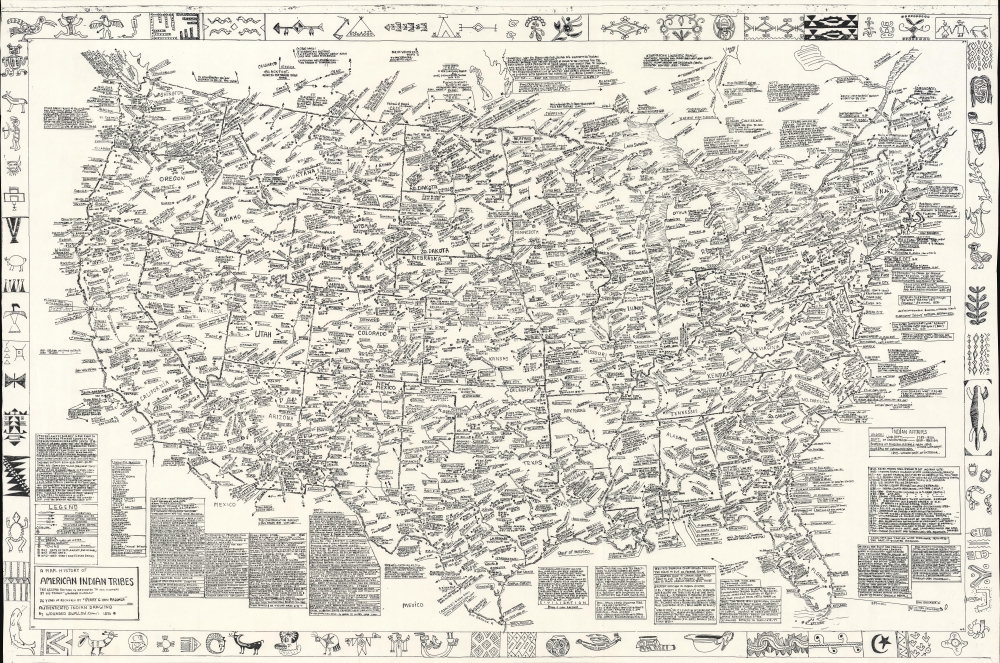
This is a 1986 Wounded Swallow map of American Indian tribes throughout the United States. It comprises a visual history of American Indians to about 1900.
A Closer Look
Dubbed a 'map-history' in the title, Wounded Swallow created this map as a tribute to his friend, the map's original creator Perry C. Van Arsdale. Information fills almost every inch of the piece. Tribes and Indian settlements are labeled, along with reservations and the dates they were established. Frontier forts are identified by name with most are accompanied by their dates of operation. Text boxes below the map provide a wide range of relevant historical information. The whole is surrounded by a wonderful pictorial border of 'authentic Indian drawing' added to the present second edition by Wounded Swallow.Publication History and Census
This map was created and published by Wounded Swallow, a Sioux, in 1986, from Perry C. Van Arsdale's first edition published in 1973. Both Van Arsdale and Wounded Swallow composed their maps by hand and their handwritten notations are easily legible. We note two examples of the present second edition cataloged in OCLC which are part of the collections at the Newberry Library and the Wisconsin Historical Society. We have been unable to locate any verifiable authentic examples of the first edition appearing on the private market. 11 examples of the first edition appear in OCLC (5405477). A dedication on this second edition reads, 'This second edition is dedicated to his memory [Van Arsdale] by his friend Wounded Swallow'. Wounded Swallow also added the present edition's pictorial border.Cartographer
Perry Charles Van Arsdale (July 29, 1910 - July 22, 1976) was an American historian, researcher, linguist, and cartographer. Born in New York, New York, Van Arsdale held two Ph. D.s: one in romantic languages and the other in mechanical engineering. He retired from being a professor and consultant at the age of 45 'with enough money to see the project through'. He began making maps as a hobby, but it soon became his career. He started producing maps around 1965, after having spent nearly two decades traveling the United States, talking with the people that lived where he was traveling, and doing research in archives. He created 9 maps in total (New Mexico, Arizona, Colorado, Texas, Illinois, Northwest, Southwest, EastSouth, and a map of the United States illustrating American Indian Tribes and telling some of their history). All his maps were hand-drawn and hand-lettered and printed in extremely small print runs. His works include thousands of locations, hundreds of which likely only appear on his maps. He and his wife Mildred spent between 15 and 20 years (the historical record is unclear) traveling the country together gathering the information that Van Arsdale eventually compiled into his maps. More by this mapmaker...
Condition
Good. Pinholing at corners. Small area of infill to upper right corner in margin. Closed minor margin tears professionally repaired on verso. Very close left and right margins. Left side trimmed to border.
References
OCLC 881237849.