This item has been sold, but you can get on the Waitlist to be notified if another example becomes available, or purchase a digital scan.
1744 Bellin Map of the Pacific Coast of Mexico, Central and South America
AmericaPacific-bellin-1744$500.00

Title
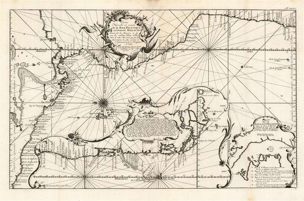
Carte nouvelle et exacte de la mer Pacifique autrement Mer du Sud / dressée sur les memoires et les avis des meilleurs pilotes et routiers de cette mer, ainsi que sur les observations les plus exactes de l'Astronomie et de la navigation en 1744
1744 (dated) 13 x 21.25 in (33.02 x 53.975 cm) 1 : 10825503
1744 (dated) 13 x 21.25 in (33.02 x 53.975 cm) 1 : 10825503
Description
This is a 1744 Bellin map of the Pacific coast of Mexico, Central and South America. This beautifully engraved, eastern-oriented chart illustrates the coast line from Acapulco, Mexico to Valparaiso, Chile. The map is continued via inset at bottom center from Valparaiso to Tierra del Fuego. A text annotation along the Chilean coastline identifies the site where Captain David Cheap, one of Anson's sub-commanders, lost his freighter, the Wager, in 1741.
Plan de la Baye de St. Francois
Another inset details the Bay of St. Francois, near Cape Horn, Chile, as discovered by Captain Joachim Durquistade in 1715. Herein lies a puzzle, as this map (and a later state) appear to be the sole printed works referring to the aforementioned captain. Two manuscript charts of this bay, reflecting the geography shown here, reside in the Biblioteca Nacional de España, each with an uncertain dating of 1715: but whether that date is based on evidence other than the 1715 date given on the Bellin map is difficult to determine. This map's appearance in Prevost's Histoire générale des voyages gives us pause, as the author's earlier Voyages du capitaine Robert Lade (after nearly two centuries of being considered authoratative) was proved in 1939 to be a largely fictional work. It is well within the realm of possibility that Captain Durquistade existed only in Prevost's imagination.Publication History and Census
This map appears to be rare on the market, with no price records since 1985. OCLC lists it only once, at the Institut Cartogràfic de Catalunya. It appeared in l'abbé Prévost's Histoire générale des voyages.CartographerS
Jacques-Nicolas Bellin (1703 - March 21, 1772) was one of the most important cartographers of the 18th century. With a career spanning some 50 years, Bellin is best understood as geographe de cabinet and transitional mapmaker spanning the gap between 18th and early-19th century cartographic styles. His long career as Hydrographer and Ingénieur Hydrographe at the French Dépôt des cartes et plans de la Marine resulted in hundreds of high quality nautical charts of practically everywhere in the world. A true child of the Enlightenment Era, Bellin's work focuses on function and accuracy tending in the process to be less decorative than the earlier 17th and 18th century cartographic work. Unlike many of his contemporaries, Bellin was always careful to cite his references and his scholarly corpus consists of over 1400 articles on geography prepared for Diderot's Encyclopedie. Bellin, despite his extraordinary success, may not have enjoyed his work, which is described as "long, unpleasant, and hard." In addition to numerous maps and charts published during his lifetime, many of Bellin's maps were updated (or not) and published posthumously. He was succeeded as Ingénieur Hydrographe by his student, also a prolific and influential cartographer, Rigobert Bonne. More by this mapmaker...
Antoine François Prévost d'Exiles (April 1, 1697 – November 25, 1763), usually known the Abbé Prévost, was a French author and novelist. Having had difficulty in his youth determining a preference for life in the military or life among the Jesuits, he eventually wound up with the Benedictines, with whom he took vows. Despite his taking the vows, the vows evidently did not take with him: in 1728 he abandoned his abbey and fled to London. Naturally, he became a writer. In this he was prolific, both producing his own work and translations of others. Beginning in 1726, he published the first volume of his Histoire générale des voyages, which he worked on for the remained of his life and which was completed by his associates after his death, stretching to 25 volumes. Learn More...
Source
Prévost, A., Histoire Générale des Voyages, ou Nouvelle Collection de Toutes les Relations de Voyages par Mer et par Terre..., (Paris: Didot) 1746 - 1759, Supplements 1761 - 1801.
Prévost's Histoire Générale des Voyages is a 15-volume compendium of travel literature initiated by Antoine François Prévost (Provost; 1697 - 1763) in 1746, intended as a universal history of exploration and geography. The initial publication, compiled from 1746 to 1759, spans 15 volumes and draws from a vast array of sources - travelers, explorers, missionaries, merchants, and diplomats - to present detailed narratives of significant global journeys. The work was initially published in Paris by Didot and offers ethnographic, political, religious, and natural observations about the peoples, cultures, flora, fauna, and geography. It is an ambitious attempt to organize knowledge about the world's diversity according to Enlightenment values, reflecting both scientific curiosity and imperial ideology. It functioned as both an informative reference and a literary work, influencing how European audiences understood and imagined distant lands. It proved extremely successful, and both reissues other publishers and pirate editions emerged, most notably Pierre de Hondt's 1747 Dutch edition and Jean-Franćois de la Harpe's 1780 abridged version. In addition to reissues of the original work, between 1768 and 1801, additional expanded volumes emerged, adding new voyages and histories. We have seen some sets with as many as 80 volumes. Over time, the Histoire générale des voyages became one of the most comprehensive and widely read travel collections of the 18th century, notable for blending factual reporting with the period's characteristic intellectual ambition.
Condition
Very good condition. Original fold lines.
References
OCLC 707477698.