This item has been sold, but you can get on the Waitlist to be notified if another example becomes available, or purchase a digital scan.
1850 Cruchley Map of North and South America
Americas-cruchley-1850$100.00

Title
America.
1850 (dated) 18 x 15 in (45.72 x 38.1 cm) 1 : 36300000
1850 (dated) 18 x 15 in (45.72 x 38.1 cm) 1 : 36300000
Description
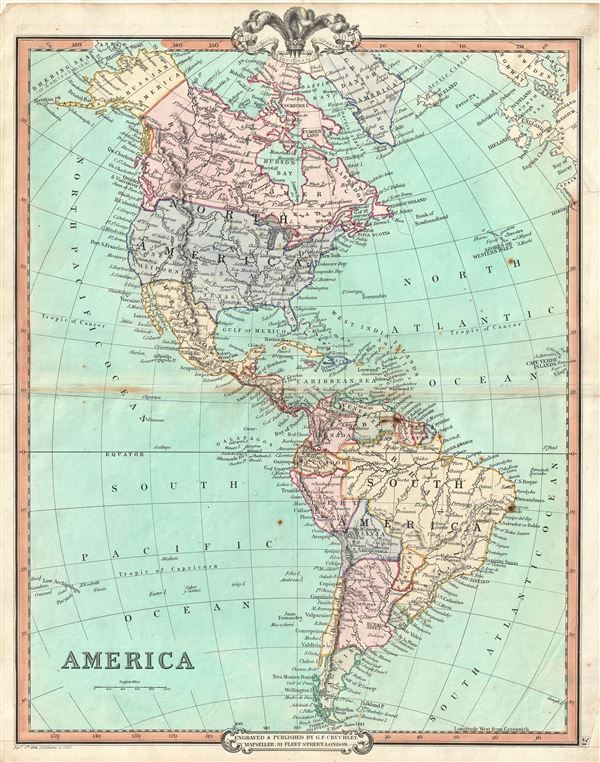
An attractive 1850 map of North and South America by George Frederick Cruchley. The map covers all of North America as well as South America from the Arctic to Cape Horn. In North America, Russian and British territories in Alaska and Canada are clearly noted. In South America, Chili extends southward only to the border of Patagonia, while Bolivia has a coast. Cruchley divides the territories and countries with color coding and notes major cities, rivers, mountains etc. Elevation is rendered in hachure.
The map offers several elements of considerable cartographic interest. The disputed border between the United States and Canada in the Pacific Northwest is set firmly at the Columbia River - recognizing, not surprisingly, British claims. In the first half of the 19th century the Pacific Northwest was the last frontier in the century's long slaughter of the American beaver in the name of European fashion. Both the British, in the name of the Hudson Bay Company, and the Americans, championed by John Jacob Astor's Pacific Fur Company, were eager to claim monopolistic right over the region. Astor's establishment of Fort Astoria on the Columbia River only served to further tensions with the Northwest Company - the Pacific subsidiary of the Hudson Bay Company. The dispute escalated, giving rise to the Oregon Boundary Dispute and the American expansionist slogan 'Fifty-four Forty or Fight!' The dispute was not resolved until the 1846 Oregon Treaty which, through concessions on both sides, formally set the boundary at the 49th parallel. The name 'Oregon,' we note, appears nowhere on this map. Cruchley's map has not been updated to reflect this border change despite an 1850 note on the imprint. This map does however predate the Gadsden Purchase despite postdating the Mexican American War, consequently the R. Gila is the southernmost boundary of the United States.
The 1850s were a period of both great hope and simmering tensions in the United States. With the end of the Mexican American War and the signing of the 1848 Treaty of Guadalupe Hidalgo, the United States acquired vast new territories. The discovery of gold in California in 1849 initiated and mass trans-continental emigration in the quest for wealth and land. California was admitted as the 31st state in September of this year and the cities of Los Angeles and San Francisco were incorporated. Meanwhile, tensions continued to rise between the slave holding agrarian southern states and the industrialized 'free' northern states. The Compromise of 1850, intended to placate the slave holding states, essentially divided the United States along lines that, by 1861, would degenerate in the American Civil War.
Meanwhile, much of South America was, at this time, embroiled in or was about to become embroiled in, severe civil strife. The new nations, freed from Spanish dominance though various wars of liberation in the previous decades, were struggling with their newfound independence in an attempt to create stable and prosperous governments. Most would dissolve into civil war between 1858 and 1864.
Cruchley's General Atlas was unique for its period, employing a vivid color scheme extending even to the oceans, distinctive typography, and various uncommon decorative elements including a peacock feather crown and an imprint medallion, both of which break the printed border. Though many of the maps in this atlas are copyrighted in 1841, the atlas was first published in 1843 from the Cruchley office at 81 Fleet Street, London, and proving popular went through numerous reissues well into the 1850s.
Cartographer
George Frederick Cruchley (April 23, 1797 - June 16, 1880) was a London based book and map seller active in the middle part of the 19th century. Cruchley began his cartographic career as an apprentice at the venerable Aaroon Arrowsmith firm. Many of Cruchley's earliest maps bear the words 'From Arrowsmith's' on the imprint. In 1844, Cruchley acquired the massive stock of the important early 19th century firm of John Cary. Cruchley published his own maps as well as reissues of Cary's stock well into the 1870s. He is best known for his detailed plans of London, which in recent years have become increasingly scarce and desirable. Cruchley was based in London on 38 Ludgate Street until 1834 when he moved his offices to 81 Fleet Street. Shortly before his death in 1880 Cruchely auctioned (Hodgson's Auctions, Jan 16, 1877) his entire stock. Many of his map plates were thusly acquired by 'Gall and Inglis' who continued the Cruchley tradition well into the early 20th century. Cruchley's son, also George Frederick (1837 - 1882), continued to work as a book and map seller until his death. More by this mapmaker...
Source
Cruchley, G. F., Selection of Maps from Cruchley's General Atlas, for the use of Schools and Private Tuition, London, 1850.
Condition
Very good. Minor wear and some toning over original centerfold. Blank on verso.