This item has been sold, but you can get on the Waitlist to be notified if another example becomes available, or purchase a digital scan.
1769 Isaak Tirion Map of the Americas
Americas-tirion-1769$212.50

Title
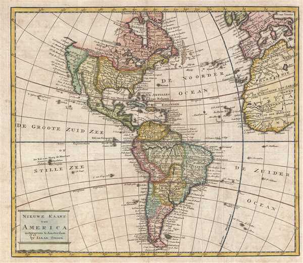
Nieuwe Kaart van America.
1769 (undated) 11 x 12.75 in (27.94 x 32.385 cm) 1 : 65000000
1769 (undated) 11 x 12.75 in (27.94 x 32.385 cm) 1 : 65000000
Description
This is a c. 1769 Isaak Tirion map of the Americas. The map depicts from the Pacific Ocean to Europe, the British Isles, and West Africa and from Hudson Bay to Tierra del Fuego. Regions throughout the Americas are labeled, including some of the British colonies which became part of the United States, such as Virginia, Carolina, and Maryland. New England is simply labeled New England and not dissected into individual colonies. Louisiana and Florida dominate the continent west of the Colonies, followed by Mexico and California. The Mississippi River is unmistakable, as it divides North America nearly in half. Each of the five Great Lakes is illustrated and labeled, whole Canada dips south as far as modern-day Missouri. Numerous locations within North America are labeled, including Boston, New York, Roanoke, Cape Hattaras, Charleston, New Orleans, and Santa Fe. Several Native American tribes are named as well, including the Illinois, Osage, and Apache.
In South America, numerous regional divisions are depicted, including Tierra Firma (Terre Ferme), Peru, the Land der Amazonen, Brazil, Paraguay, Chili, and the Land van Magelaan. Each of these regions vary greatly from the modern-day geography of South America, but the divisions are intriguing. Tierra Firma was a province of Spain's New World Empire containing Spain's mainland coastal possessions surrounding the Caribbean Sea. The Land der Amazonen splits modern-day Brazil in two, and separates the Amazonian region into its own entity. Myriad rivers, lakes, and cities around South America are labeled, including Quito, La Paz, Asuncion (Assumption), Sao Paolo, Buenos Aires, and Cartagena. The Rio de la Plata is labeled and easily recognizable, along with the Amazon River and the Andes.
By far the most intriguing aspect of South American geography here is the speculative geographic element common to earlier maps of the region, the Lago de Xarayes. The Xarayes, a corruption of 'Xaraies' meaning 'Masters of the River,' were an indigenous people occupying what are today parts of Brazil's Matte Grosso and the Pantanal. When Spanish and Portuguese explorers first navigated up the Paraguay River, as always in search of el Dorado, they encountered the vast Pantanal flood plain at the height of its annual inundation. Understandably misinterpreting the flood plain as a gigantic inland sea, they named it after the local inhabitants, the Xaraies. The Laguna de los Xarayes almost immediately began to appear on early maps of the region and, at the same time, took on a legendary aspect as the gateway to the Amazon and the kingdom of El Dorado.
This map was produced by Isaak Tirion and published c. 1769.
Cartographer
Isaak Tirion (1705 - 1765) was a Dutch publisher in Amsterdam. Born in Utrecht, Tirion quickly rose to prominence by publishing pamphlets, historical works, and most importantly, maps and atlases. He produced several atlases and Dutch town plans. His maps are mainly based on those of Guillaume de l'Isle. Tirion eventually relocated his printing house to the prestigious Kalverstraat. In his long career, he produced eight atlases in multiple editions, some of which were published posthumously until about 1784. More by this mapmaker...
Condition
Very good. Light wear along original fold lines. Blank on verso.
References
OCLC 950544670.